 Page Contents
About the walk
- Start address: Near Broadmoor car park, Wotton, RH5 6JY
- Distance: 6 miles
- Approximate time: 3 hours
- Grid references: Broadmoor TQ136457, end of section at Deepdene (Dorking) TQ175491
- OS Explorer Map: 146
Walk directions
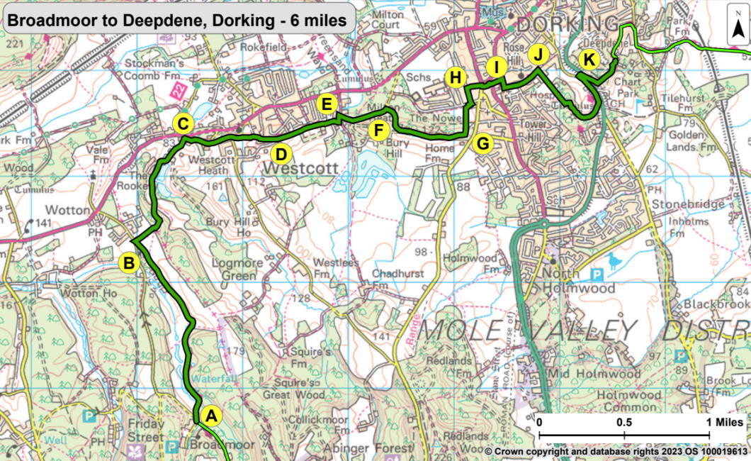
The following letters correspond with the route directions on the map.
A. If starting from Broadmoor car park, look for the brown Greensand Way sign on the signpost. Keep right along the track. Cross the River Tillingbourne and walk down the right side of the valley, following the main track for one mile to a private drive.
B. Continue right along the drive for 35 yards. Reach a lane and turn sharp right along a footpath beside a cinder track. Keep right at the junction of tracks, then turn left under a beech tree and follow a footpath, going downhill through woodland. Keep right at a metalled drive and continue to pass the entrance pillars to Rookery Drive at Westcott.
C. Turn right along a sandy path and continue uphill past a quarry. At a T-junction keep ahead on the footpath. Cross a lane, keep left and continue along Westcott Heath, running parallel with the lane. Cross a lane that leads left downhill to Holy Trinity Church. Continue ahead through more woodland to Heath Rise, just above The Cricketers.
D. Cross Heath Rise. Continue ahead along a footpath behind gardens. Go through a barrier and across a metalled parking area behind houses. Continue along a hedged path, then pass a field entrance and continue downhill.
E. Cross a footbridge over a stream. Turn left, then turn right after 90 yards and go up steps. Go through a gate and turn left along a metalled track. Walk along the lane for 330 yards.
F. At small clearing in woodland, turn right just past a horse barrier. Keep right where the path forks after 45 yards. Continue uphill through trees to reach The Temple at the top of The Nower. Continue ahead past The Temple for 550 yards.
G. Turn left at a seat and go down the slope to the far right-hand corner of a field. At the end of beech hedging turn right between hedges. Go to the left of a gate and cross Hampstead Lane. Turn right, then left along Nower Road. Continue for 165 yards.
H. Turn right by a post box and walk ahead to continue along a footpath leading down-hill. Go through barriers onto the pavement by Vincent Lane (A25 and A2003 in town one-way system). Go round the left of the barrier to cross the road ahead (Vincent Lane) and then go into South Street to regain the original direction. Use the pedestrian crossing to cross to the right-hand side of South Street. Turn left. Cross road (A2003), using the central reservation, and go up a narrow path to the right of The Queen's Head.
I. Go between barriers at the top. Turn right along Peacock Walk, then turn left between barriers into St Paul's Road. Where the road bears right uphill, into South Terrace, keep ahead along St Paul's Road West.
J. Turn right just before St Paul's C of E School. Go through a gate and continue ahead uphill. Go through another gate into The Glory Wood. Immediately turn left onto a crossing path. Through woods, bend right with the path, then left uphill. Descend steeply to 3-way signpost. Then keep left and walk down to join the road.
K. Turn right at Chart Lane to reach the main road (A24). Cross Deepdene Avenue, using the central reservation. Turn left along the road for 10 yards, then turn sharp right uphill. Where the track goes right, turn left and go uphill to steps. Follow a broad track to a horse barrier. Turn left onto a metalled track by Deepdene End.
What to see
Tillingbourne Falls: A Dutch merchant named Jacobson built the ornamental waterfall around 1740 as part of the Evelyns' of Wotton Estate garden landscape scheme. It took its head of water from ponds at a mill upstream at Brookmill.
Wolven's Lane: The name means 'foul or muddy fen' referring to the damp slopes. Smugglers used this ancient road in the 18th and early 19th century to bring contraband to London from the south coast.
River Tillingbourne; The River Tillingbourne rises from springs at the junction of the Hythe Beds and the Atherfield Clay on the dip slope of the Lower Greensand.
Pipp Brook: This important tributary of the River Mole flows through Dorking. At one time it supported seven watermills and one water-pumping mill in its five-mile length, including Pixham Mill at Dorking.
Holy Trinity Church, Westcott: Known as Westcote in the Domesday Book, at the west end of the parish of Dorking. Westcott only acquired its own church in 1851 to 1852 on land given by the Evelyn family. Sir George Gilbert-Scott designed it in 14th century style.
The Temple: The Temple and its seat were built early in the 20th century by the Barclay family who gave the Nower to Dorking in 1931.
Dorking became a market centre for outlying districts as early as Saxon times. In medieval times timber from the local hillsides was transported through Dorking for use in London and other larger towns.
Box Hill: Named after the evergreen box trees which grow on its slopes above the River Mole, Box Hill offers a mixture of habitats, some mature woodland, some open chalk downland. Managed by the National Trust, in winter sheep graze its thousand acres to help conserve the plant life.
Map 6
Map Six covers the area from close to Broadmoor car park towards Rookery Drive, along the paths above Westcott and the Nower. It continues on to reach the outskirts of Dorking, Glory Wood and then Deepdene where this section ends. Select the map of the route below to open a larger version in a new window, that can be printed, if necessary, using your browser print tool with landscape selected. Alternatively, you can save the image to your mobile device, for reference on your walk.


