About the walk
A pretty walk around the Banstead countryside close to Chipstead, walking through chalk grassland, mixed woodlands and open farmland, all rich habitats for a variety of wildlife, flora and fauna.

Route details
- Start and end address: Holly Lane free car park, Chipstead
- Car park postcode: CR5 3NR
- Difficulty: challenging terrain
- Distance: 5 miles, 8 kilometres
- Type of walk: circular
- Approximate time: 3 hours
- Accessibility: several kissing gates, bridle gates plus some steps and steep slopes
- Facilities: None on the route, shops in Chipstead village or The Ramblers Rest pub on Outwood Lane
- Ordnance Survey Map: 146 Dorking, Box Hill and Reigate
Getting there
By car: The walk starts and finishes from Holly Lane car park near Chipstead village which is free of charge and has a 1.9 metre height restriction barrier.
By train: Chipstead railway station is around 500 metres from Holly Lane car park, about a five minute walk.
By bus: Take a look at Surrey bus timetables for details of public transport.
Points of Interest
This walk follows paths through chalk grassland, mixed woodlands and open farmland, all rich habitats for a range of wildlife and flowers. Chiphouse Woods is is a section of ancient semi-natural woodland with an amazing springtime display of bluebells and you will notice mature oak and beech trees as well as the rich ground flora, that provide striking autumn colours.
Coal Tax Posts were installed to indicate the boundary to London where coal duty was payable to help fund the rebuilding of the city after the Great Fire of London. In 1861 an Act of Parliament changed the boundary for coal tax and a ring of these posts between 12 and 18 miles from London, were installed to show the boundary within which duty was payable.
Park Downs is a beautiful area of chalk grassland. In summer rare plants such as greater yellow rattle and many orchids grow here, including pyramidal, bee and fly orchids. These plants support a large population of butterflies, including common and chalkhill blue, orange tip and various skippers. There are also interesting birds here, look out for summer-visiting warblers such as whitethroats.
Walk directions
This walk follows public footpaths and bridleways which cross private and public land. If you come across a problem on a public right of way, please notify us on our online fault reporting form.
For any feedback on this walk email us: countryside.bookings@surreycc.gov.uk.
Stages from start point through 1 to 6 to end of walk
Please follow the Countryside Code.
The following numbers correspond with route points on the map.
- Start to crossroads
- Stage 1: Crossroads to coal tax post
- Stage 2: Coal tax post to rail underpass
- Stage 3: Rail underpass to Reads Rest Lane
- Stage 4: Reads Rest Lane to Ruffett Wood
- Stage 5: Ruffett Wood to Park Downs
- Stage 6: Park Downs to end
Start to crossroads
Standing in the Holly Lane car park with your back to the vehicle exit barrier walk directly ahead uphill to reach the enlarged wooden kissing gate in the middle of the top car park boundary. Pass through this gate and follow the path past one information board on your right and then past a fenced information area on your left. As you reach the first signpost continue ahead on the footpath signed to Perrotts Farm. On this signpost you will notice the first of the Banstead Countryside Walk route symbols, a green ring with a brown bird at the centre, you will be following these throughout the walk to indicate directions.
Pass under a large yew tree and you will see a choice of three paths ahead. Take the left-hand one and follow this path with a wire fence running on your left and Banstead Woods immediately on your right. This stretch of path is known as the Yew Walk and you will pass a number of beautiful yew trees. Further along the path you will reach a bench on your right and kissing gate on your left, a good spot to pause and enjoy the views over the valley. Ignore the kissing gate, simply continue on the same path which later leads you along a narrow strip of trees, with the chalk grasslands of Chipstead Downs visible both to your left and right. Ignore any side paths, continue on this path which eventually bends left and downhill to reach a crossroads with a tall signpost on your right.
Stage 1. Crossroads to coal tax post
Turn right here to join the public footpath signed to Banstead Woods. This path leads you ahead with a wire fence on your left and trees on your right. When the wire fence on your left ends continue ahead on the obvious woodland path. The path climbs steadily and leads you past an impressive line of old beech trees. Beyond these trees you will come to a point where the path splits in two. Take the right-hand path and soon after you will reach a signpost marking a T-junction in the path. Turn left to continue on the Banstead Countryside Walk and follow the woodland path ahead. Please note: The next landmark and turn is easy to miss. After about 250 metres look out within the trees to your right for a waist-high, white-painted, cast-iron post. This is set back from the path by about 15 metres. It is a Coal Tax Post which dates from 1861.
Stage 2. Coal tax post to rail underpass
Stay on the same path for a further 10 metres to reach a small side path to your left. Turn left here and follow the narrow path downhill. Towards the bottom go down the flight of steps and then turn left through a kissing gate. Just beyond the gate the path comes out from the trees and continues along the left-hand edge of a grass meadow, with woodland on your left and the railway line visible down to your right. Continue to a point about 100 metres before the end of the grass meadow where you will see a choice of paths. Turn right here heading directly down the slope of the hill. Pass through an old gateway and kissing gate and walk ahead to pass under the railway via the brick arch.
Stage 3. Rail underpass to Reads Rest Lane
After passing under the railway line you will come to a path T-junction. Turn right on the path signed towards Kingswood. Follow this fenced and tree-lined path with the railway running to your right. After 200 metres pass through the kissing gate ahead to enter Chiphouse Wood. Follow the main wide path leading you ahead through the woodland. At the far end of Chiphouse Wood, you will go through a kissing gate to reach a T-junction with a public bridleway. Turn right signed to Reads Rest Lane and almost immediately you will pass another coal tax post on your right. The bridleway leads you under the railway and then continues very gently uphill between hedgerows. Eventually you will arrive at a bridle gate, go through to reach a T-junction with a track known as Reads Rest Lane.
Stage 4. Reads Rest Lane to Ruffett Wood
Turn left along Reads Rest Lane and follow this to pass a pair of white cottages, Reads Rest Cottages, on your right. Immediately after these cottages turn right onto a farm track, passing old and new barns on your right and passing alongside a gate to reach the corner of a crop field. Keep left to follow the field edge path with a hedgerow running on your left. About half way along this very large crop field you will come to a tall signpost on your left. Turn right here on the public footpath signed to Holly Lane. The footpath leads you diagonally through the crops to reach a tree line and signpost at the far side.
Keep right, signed Holly Lane, passing alongside an old kissing gate and passing through a strip of trees. You will come out at the corner of a second crop field. Turn left to follow the field edge path with the trees running on your left. Before the end of the field turn left alongside an old kissing gate to join the path which runs along the edge of the woodland. As you reach a signpost ignore the footpath off to the left, instead continue ahead and you will soon arrive at the corner of a third crop field. Keep straight ahead along the edge of this third crop field with the woodland known as Ruffett Wood on your right and fine views of a hillside mansion in the distance ahead.
Stage 5. Ruffett Wood to Park Downs
Follow the field-edge path down to reach a T-junction with a signpost. Turn left signed to Holly Lane and follow the path along the edge of the field and then enter another strip of trees alongside an old stile. Ignoring the two side paths, go straight ahead to follow the narrow path uphill through the trees. Where the path splits take the right-hand path which leads you over the top of the hill and then descends, arriving at a concrete access road alongside Holly Lane.
Walk straight ahead crossing the access road and then crossing Holly Lane itself. After crossing the road turn sharp right and then left to reach the corner of a crop field. Walk ahead along the field-edge path with the tree line on your left. As your path continues to go uphill you will be rewarded with lovely views. At the far end of this field turn right heading downhill along the field edge for about 50 metres to reach a signpost on your left. Turn left here signed to Park Road and follow the path leading you into woodland. This woodland marks the start of the area known as Park Downs.
Stage 6. Park Downs to end
Follow the path leading you through the short section of woodland and coming out to chalk grassland. Walk straight ahead on the obvious path which leads you along the length of Park Downs. You will come to a signpost marking a junction of multiple paths. Go straight ahead following the line of a fence on your right for 100 metres to reach the Banstead Commons noticeboard. Pass this noticeboard on your right and continue for a further 90 metres to reach another split path. Take the smaller left-hand path leading you through the trees to reach Park Road, cross this road and continue on the footpath on the far side. The path bends left to reach another point where the path splits in two. Take the left-hand path marked with a tall signpost. Follow this woodland path ahead with a chain-link fence and later a wooden fence, visible just to your left. After around 400 metres you will reach a signpost on your left Please note: this is easy to miss.
Turn right here to join the signed permissive path leading downhill through the trees. After the first short stretch the path bends left and continues diagonally downhill through the woodland. You will come out from the trees to the corner of a grass clearing. Go straight ahead crossing over another grass path and then follow the left-hand edge of the clearing leading you downhill. At the bottom you will arrive at the road. Turn left along the verge for a few paces and then turn right across the two roads, Park Road and Holly Lane, to reach the car park where the walk ends.
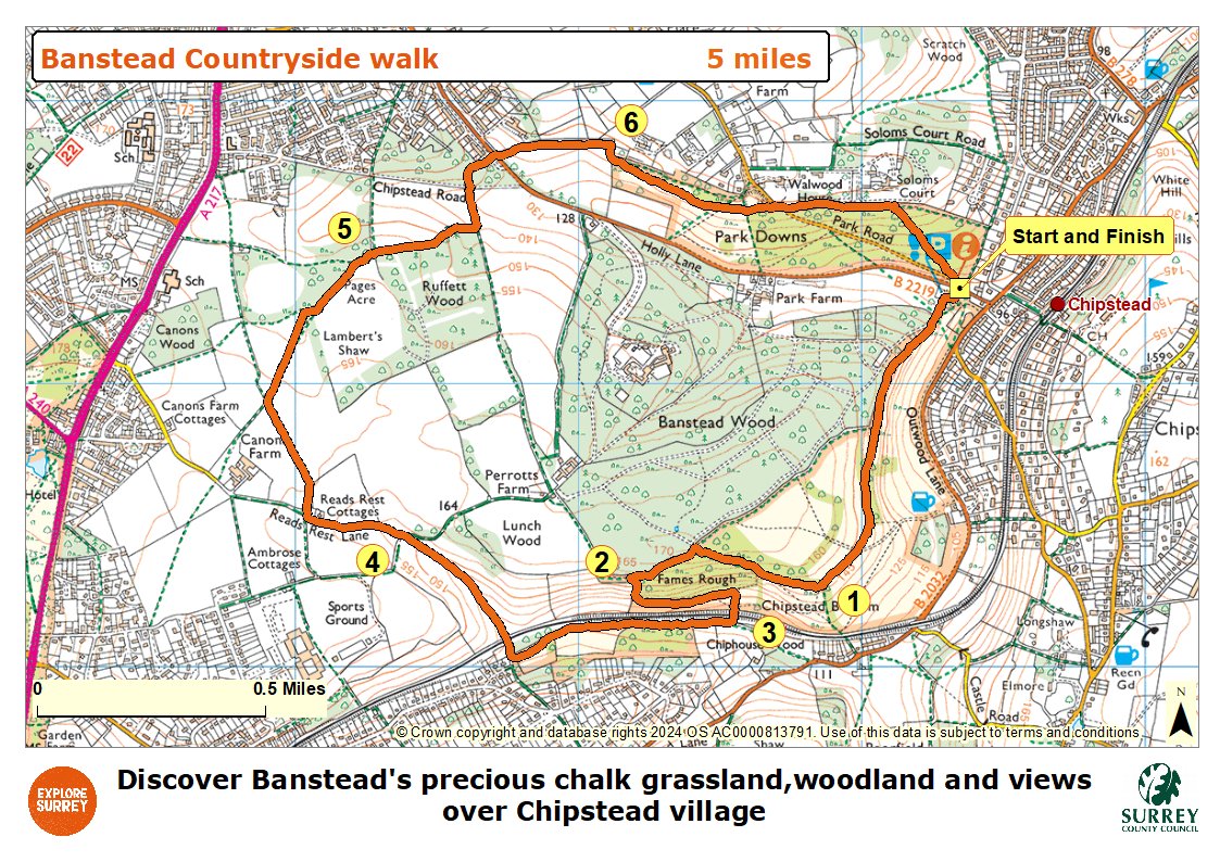
Map
The map shows the route from its start at Holly Lane car park towards Chipstead Downs and into Banstead Woods. The route goes under the railway line towards Reads Rest Lane via Chiphouse Woods. Public paths are signposted across 3 crop fields of Canon Farm into Ruffett Wood and then to Park Downs. The route crosses Park Road and Holly Lane to return to the car park where the walk finishes. Select the map of the route below to open a more detailed version in a new window that can be printed if necessary, using your browser print tool. Alternatively you can save the image to your mobile device for reference on your walk.