About the walk
A flat circular walk taking you on a journey through time where new meets old and built up areas merge with farmland, streams and woodland. You'll encounter World War II pillboxes, hints of the tanning industry and the mysterious site of Thunderfield Castle.

Route details
- Start and end address: The Farmhouse pub, Ladbroke Road, Langshott
- Car park postcode: RH6 8PB
- Difficulty: moderate terrain
- Distance: 6 miles, 9.5 kilometres
- Type of walk: circular
- Approximate time: 3 hours
- Accessibility: not suitable for wheelchairs or buggies due to several steps, gates and stiles
- Facilities: no toilets or picnic spots on the route itself. Refreshments and toilets are available at The Farmhouse pub
- Ordnance Survey Map: Explorer 146 Dorking, Box Hill and Reigate
Getting there
By car: There is a small amount of roadside parking directly outside the Farmhouse pub or if you continue past the pub on your left, you will reach a small parking lay-by on the right.
By bus: Several buses serve Horley and the nearest bus stop is on the A23 at Chestnut Road, a five-minute walk from the pub. Take a look at Surrey bus timetables for further details.
By train: Horley Station is under 1 mile walk from the start. Walk along Station Approach for 300 metres to reach the T-junction, turn left along Balcombe Road for 400 metres and turn right along Ladbroke Road for 200 metres to reach the pub.
Points of Interest
You will see many pillboxes on this route. They were constructed from concrete as defences against invasion in World War II.
Scotchman's Copse at walk stage 3 holds a tanning pond where leather was treated in the 1500s. This rare feature is now listed as an Ancient Monument. Nearby there used to be a farm called 'Tanyard Farm' which was a link to the tanning industry.
Haroldslea Drive may have been the path taken by King Harold on his way to the Battle of Hastings in 1066, walking to rest for the night at Thunderfield Castle which was situated across to the right.
Walk directions
This walk follows public footpaths and bridleways which cross private and public land. If you come across a problem on a public right of way, please notify us on our online fault reporting form.
For any feedback on this walk email us: countryside.bookings@surreycc.gov.uk.
Stages from start point through to end of walk
Please follow the Countryside Code.
The numbers of each stage of the walk correspond with the points shown on the map.
- Start to Great Lake Farm
- Stage 1: Great Lake Farm to narrow copse
- Stage 2: Narrow copse to treatment works
- Stage 3: Treatment works to Smallfield Road
- Stage 4: Smallfield Road to Haroldslea Drive
- Stage 5: Haroldslea Drive to Langshott Lane
- Stage 6: Langshott Lane to end
Start to Great Lake Farm
Standing on Ladbroke Road facing the pub, turn right along the lane passing the parking lay-by on the right and houses on the left until you come to a crossroads. Turn left into Lake Lane signed as a cycleway to Greenwich and Redhill. Pass the school on the right and continue straight ahead at the crossroads with Brookfield Drive. Beyond the housing development, ignore the footpath to the right and simply walk straight ahead along the lane. You will pass Great Lake Farm on the left.
Stage 1. Great Lake Farm to narrow copse
Walk ahead along the lane which crosses Burstow Stream and then leads you under power line with a pylon on the left. Shortly after the pylon where the lane bends right turn right through a kissing gate to join the signed public footpath. Walk ahead but slightly to the left passing to the left of the tree in the field centre to cross a stile into a second field. Cross this field at to reach a narrow gateway in the centre of the far hedgerow. Cross the wooden footbridge into the third field. Walk straight ahead heading for the wide gate opposite, where you will find a kissing gate hidden in the hedge to the right of it. Pass through this to enter a fourth field, a large crop field. You will see another pillbox on the left.
Walk straight ahead across this field heading for the house and telegraph pole opposite. Before you reach the house you will see a wide gate in the hedge on the right with a stile alongside. Cross this stile and turn sharp right crossing the field diagonally right. Cross another stile and then walk straight across this next pasture, noting another pillbox across to the right. You will come to a stile and footbridge ahead at the edge of a narrow copse.
Stage 2. Narrow copse to treatment works
Cross the stile and footbridge, pass through the copse and another stile-footbridge combination leads you into the next field. The copse ahead and to the right, Scotchman's Copse, holds a tanning pond. Walk directly ahead staying close to the ditch on the right. In the field corner you will see a concrete and metal footbridge. Do not cross this, instead turn left and stay close to the right-hand field boundary, with Burstow Stream running to the right. At the end of the field cross the footbridge via two metal gates and you will see another pillbox ahead. Do not walk towards this, instead turn right and follow the line of Burstow Stream to your right.
Follow this waterside path for some distance crossing three more footbridges along the way (each with stiles or gates at each end). Continue along the right-hand boundary of this next field and you will come to a footbridge with stiles within the right-hand hedge. Cross this fourth bridge and go straight across the smaller field. A fifth footbridge with stiles leads you to a path alongside a sewage treatment works.
Stage 3. Treatment works to Smallfield Road
Follow the path with the treatment works on the left and Burstow Stream on the right. The path swings right to cross another footbridge with stiles and leads you out to the corner of an open area of heath. Turn immediately left following the line of dense hedgerow on the left. Pass through the gap to the left of a small tree and line of old wooden fencing and then continue ahead, staying close to the hedgerow on the left (passing the old wooden fencing and a pylon to the right). After 250 metres you will come to a T-junction with a surfaced bridleway, turn left along this and follow it over a stream. Pass a pylon on the left and further along go through a gate to reach a junction with Smallfield Road.
Stage 4. Smallfield Road to Haroldslea Drive
Cross over the road and take the signed public byway directly ahead. Follow this long straight path between trees and hedgerows for some distance. The byway eventually joins the corner of a small road, Peeks Brook Lane. Go straight ahead along this lane and then walk ahead along the road passing between properties. You are now heading towards Gatwick and moving ever closer to the M23 which is running across to the left. You will notice that the trees lining the first stretch of track are predominantly willow.
At the end of the woodland stretch walk straight ahead between a couple of properties and follow the lane left over a stream. Pass Peeks Rough Farm on the right and, about 50 metres before the motorway bridge overhead, turn right onto the public footpath signed to Balcombe Road. Follow this narrow path with the fence for the goods yard on the right. The path leads you over a footbridge and up some steps to continue with open fields visible to the right. You will reach a signed junction with a stile ahead. Turn right here, signed to Horley and follow this fenced path between pastures. At the end of the first long field, keep straight ahead at the junction and you will arrive at a kissing gate to reach a T-junction with Haroldslea Drive.
Stage 5. Haroldslea Drive to Langshott Lane
Further along Haroldslea Drive the lane will lead you back over Burstow Stream. Follow the lane ahead which then bends sharp right and you will see the double moat of the old castle site in the trees to the left. Follow the road which bends left around the castle site until you reach Coldlands Farm directly ahead. If you glance to the left here you will see a signpost marking a footpath junction just after the three garages. Turn left here onto the public bridleway with a fence running on the right. After 100 metres at the signed junction turn right and follow this path through the pretty woodland corridor.
You will come out alongside the buildings of Harrowsley Green Farm. Follow the signed bridleway walking ahead past the barn on the right, turning right along the concrete track and then turning left along the farm's tarmac drive. At the end of the drive you will come to a T-junction with Smallfield Road. Cross over but do not take the bridle gate ahead. Instead turn left along the pavement for a few paces and then turn right onto the tarmac track, Langshott Lane, signed as a bridleway.
Stage 6. Langshott Lane to end
Cross the concrete bridge and walk ahead on the tarmac track lined by oak, hazel, holly and rhododendrons with big houses on either side. After passing the last property on the right, Keeper's Cottage, keep ahead as the bridleway becomes a byway and you will pass Brook Wood on the right. Beyond the woodland the lane leads you into the eastern end of a housing development. Just before the road bends left you will see Langshott Manor through the railings on the left, an Elizabethan building with a moat. Stay on the main lane which bends left and then continues ahead until you arrive at the crossroads with Lake Lane. Keep straight ahead here and you will reach the end of the walk, the parking lay-by on the left and The Farmhouse pub a little further along on the right.
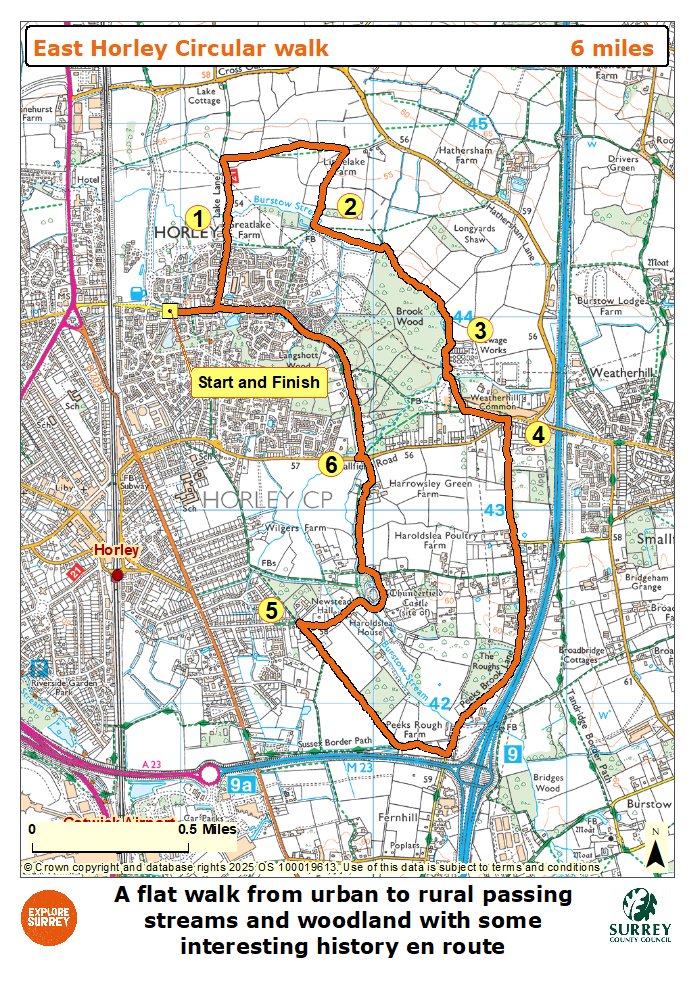
Map
The map shows the walk from the start to Great Lake Farm and on to narrow copse and along the Burstow Stream towards the treatment works through Brook Wood and the junction with Smallfield Road. From here it goes along Peeks Brook Lane for some distance joining Sussex Border path briefly before reaching Haroldslea Drive. Then on past the site of Thunderfield Castle towards Langshott Lane and through Langshott Wood to the end of the walk. Select the map of the route below to open a more detailed version in a new window that can be printed if necessary, using your browser print tool. Alternatively you can save the image to your mobile device for reference on your walk.