About the walk
An undulating 3 mile circular walk near Coulsdon, taking in the beautiful rolling chalk grassland of Farthing Downs and Happy Valley with great views to the London skyline.

Route details
- Start and end address: Farthing Downs car park (charges apply), Ditches Lane
- Car park postcode: CR5 1DA
- Difficulty: moderate terrain
- Distance: 3 miles (5 kilometres)
- Type of walk: circular
- Approximate time: 1.5 hours
- Accessibility: several climbs and descents on chalky surfaces that can be slippery. One flight of steps, no stiles
- Facilities: toilets in the car park at the start of the walk
- Ordnance Survey Map: Explorer 146 Dorking, Box Hill and Reigate
Getting there
By car: The walk starts and finishes at the Farthing Downs car park on Ditches Lane. Leave the A23 at Coulsdon and at the roundabout take the B276 signed to Caterham. Take the second right turn, Downs Road and keep left at the split in the road into Ditches Lane. Follow this single track lane over a cattle grid and up to the top of the downs. Just before you reach cottages on your left, you will come to the car park on the right. Note: parking charges apply. Approximate post code CR5 1DA.
Points of Interest
This walk starts from Farthing Downs which has stunning panoramic views across the surrounding countryside and all the way to London. Farthing Downs and Happy Valley are both designated a Site of Special Scientific Interest (SSSI) with Farthing Downs being part of the largest area of chalk grassland habitat remaining in the Greater London area. In 2019 this area was designated as a National Nature Reserve by Natural England.
Happy Valley is an area of chalk grassland, where more than 50 kinds of wild flower can be found in a square metre of land. Many chalk-loving orchids grow here, along with the nationally rare greater yellow-rattle. You will also be walking through areas of ancient woodland, carpeted in bluebells in the late spring.
Chaldon Church, visible just beyond Chaldon Green, is famous for its Doom Painting on the west wall. Dating from 1200, the painting features 'the ladder of salvation of the human soul' and is one of the finest and oldest in England.
Walk directions
This walk follows public footpaths and bridleways which cross private and public land. If you come across a problem on a public right of way, please notify us on our online fault reporting form.
For any feedback on this walk email us: countryside.bookings@surreycc.gov.uk.
Stages from start point to end of walk
Please follow the Countryside Code.
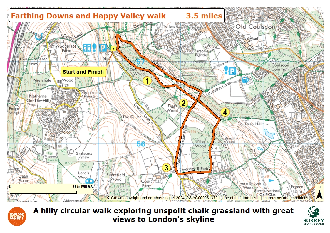
The numbers of each stage of the walk correspond with the points shown on the map.
- Start to grassland
- Stage 1: Grassland to hedgerow path
- Stage 2: Hedgerow path to Chaldon Green
- Stage 3: Chaldon Green to bottom of valley
- Stage 4: Bottom of valley to end
Start to grassland
From the car park cross over Ditches Lane and walk down the grass bank opposite, staying close to the Farthing Down cottages running on your right. Where the cottages on your right end turn right to join the chalk path leading you past a vehicle barrier. Keep ahead on this main path through the ancient woodland ignoring any side paths, with the trees uphill to your right and downhill to your left. When you reach a divide in the path keep left still following the main track going downhill until you arrive at an area of open chalk grassland. Keep slightly right along the edge of this grassland following the line of the woodland on your right with the grass going downhill to your left.
Stage1. Grassland to hedgerow path
About half way along the clearing ignore the footpaths into the woodland on your right, instead continue following the right-hand edge of the clearing as it bends steadily left and downhill to reach a signpost. Turn right at this point passing through the wide gap in the woodland and then keep ahead, staying fairly close to the woodland edge running on your left. Continue just until you reach a hedgerow crossing your path. Do not pass through the hedge, instead turn right heading uphill keeping the hedgerow on your left.
Stage 2. Hedgerow path to Chaldon Green
At the top corner keep straight ahead to join a stone track leading you through a section of trees signed as a public footpath to Chaldon Church. When you arrive at the edge of a large crop field take the path heading diagonally left across the field. As you draw level with a corner of woodland on your right stay with the path which now bends further to your left, leading you diagonally across the next section of crop field. The path leads you over the hill and then heads downhill towards a strip of trees. Pass through the trees and turn left along Ditches Lane. At the point where the lane splits in two directions take the left-hand path. The grass triangle on your right is known as Chaldon Green and is the smallest registered common in England.
Stage 3. Chaldon Green to bottom of valley
You will soon see Chaldon Church to your right. About 30 metres beyond the green turn left onto the footpath signed to Piles Wood. Pass through the hedgerow gap and follow the path with the crop field which you just crossed, on your left and fenced paddocks on your right. In the top right-hand corner of the crop field continue ahead on the grass track with the fence line on your right and Piles Wood running on your left. At the end of the path you will come to a junction with a tarmac access track. Turn left on a bridleway signed to Happy Valley with Piles Wood still on your left, walking past a number of properties on your right. When the tarmac track ends simply keep ahead on the stone and dirt path following a fence line running on your right. The path begins to descend and when the woodland on the left ends, you will come to a junction. Ignore the path to the left, keep ahead with a section of open grassland visible through the trees on your left. At the bottom of the hill you will come to a signpost marking a crossroads at the bottom of Happy Valley, turn left here and join the path along the bottom of the valley.
Stage 4. Bottom of valley to end
Follow the path at the bottom of the valley with the grassland uphill to your left and woodland on your right. Further along you will meet a hedgerow crossing your path, pass through the hedge and turn immediately right to join a smaller path leading you up through the woodland via a flight of steps. As you come out from the trees continue up the steps passing a bench on the left. At the top you will come to a T-junction. Turn left onto the footpath signed to Farthing Downs. Follow this path down the hill across the grassland and between a few benches. The path leads you through a strip of trees, keep ahead going downhill until you reach a junction of paths at the valley bottom. At the first crossroads, recognisable by the stone path running uphill to the right, go straight ahead. A few paces later turn right and join the grass path along the valley bottom leading you past a small group of blackthorn bushes and a bench on your right. At the far end of this grassland go ahead on the wide track through the trees and you will come to a narrower area of grassland.
Keep straight ahead and you will soon join a stone path coming in from the right. Further along follow the stone path as it bends right passing a memorial bench to your left. At the next right-hand bend on the path just before the grassland narrows to a single track, turn left into a wide gap within the woodland. A very short distance along you will reach a point where the path divides in two. Take the right-hand path heading diagonally uphill. As you enter a section of trees you will see a bench, turn sharp left here and follow the path continuing uphill through the trees. Towards the top turn right to reach the corner of the Farthing Downs cottages. Turn sharp right and then left walking uphill with the cottages to your left. At the top of the hill you will reach the car park where the walk ends.
Map
The map shows the walk from Farthing Downs car park across Ditches Lane, through Devilsden Wood and beyond to Chaldon Green. It then goes through Piles Wood, across crop fields towards the valley bottom of Happy Valley to return to the start at the car park. Select the map of the route below to open a more detailed version in a new window that can be printed if necessary, using your browser print tool. Alternatively, you can save the image to your mobile device for reference on your walk.