About the walk
A circular walk near the village of Limpsfield which is close to the Kent border. The walk explores several sections of woodland common, including High Chart and Limpsfield Common, set along the hilly slopes of the Greensand Ridge.

Route details
- Start and end address: National Trust Moorhouse car park on Moorhouse Road is free of charge and has a height barrier.
- Car park postcode: TN16 2ES
- Difficulty: challenging terrain
- Distance: 5 miles, 8 kilometres
- Type of walk: circular
- Approximate time: 2.5 hours
- Accessibility: several kissing gates and bridle gates but no stiles
- Facilities: refreshments at The Carpenters Arms on Tally Road just after walk stage 2
- Ordnance Survey Map: Explorer 147 Sevenoaks and Tonbridge
Getting there
By car: from Limpsfield, head east on the A25 and then turn right onto Moorhouse Road directly opposite The Grasshopper Inn. Follow the lane around three bends and beyond the houses you will find the car park on your right.
By bus: Adjust the walk to start on Tally Road (walk stage 2) in Limpsfield Chart, where there are bus stops served by route 594. Take a look at Surrey bus timetables for details of public transport.
Points of Interest
Limpsfield Common was part of the medieval Manor of Limpsfield. The infertile soils here on the Lower Greensand Hills were used for the production of timber and firewood and for rough grazing but today the site is used for recreation. There are magnificent beech trees, some around 200 years old and the woodland is carpeted with bluebells in spring.
Yaldon Spring is one of several springs on the northern slope of the Greensand Ridge.
The Greensand Way long distance trail runs for 53 miles across Surrey broadly along the Greensand Ridge. It starts in Haslemere and crosses into Kent just beyond Limpsfield Chart to finish at Ham Street in Kent 108 miles later. Take on the challenge of walking the whole Greensand Way trail or find out about shorter linear sections in Surrey.
Walk directions
This walk follows public footpaths and bridleways which cross private and public land. If you come across a problem on a public right of way, please notify us on our online fault reporting form.
For any feedback on this walk email us: countryside.bookings@surreycc.gov.uk.
Stages from start point to end of walk
Please follow the Countryside Code.
The following numbers correspond with route points on the map.
- Start to Yaldon Spring
- Stage 1: Yaldon Spring to Tally Road
- Stage 2: Tally Road to Spring Cottage
- Stage 3: Spring Cottage to Moat Farm
- Stage 4: Moat Farm to Tenchleys Manor pond
- Stage 5: Tenchleys Manor pond to Pastens Cottage
- Stage 6: Pastens Cottage to golf course
- Stage 7: Golf course to end
Start to Yaldon Spring
Leave the car park via the vehicle entrance, cross over the lane and go straight ahead on the signed public footpath leading you through the gateway in the area of woodland known as High Chart. Keep ahead on the track for just a few paces to reach a signpost and turn right joining a narrow footpath leading you through the woodland plantation. Follow the footpath winding through the trees and then downhill to reach a crossroads with a sunken footpath with a signpost ahead. Turn right to join the sunken path. At the end of the path you will arrive at a junction with a stone vehicle track with double metal gates onto the road visible just to your right.
Turn left for a few paces and then turn right to join the continuation of the public footpath. After around 150 metres you will reach a point where the path splits in two with a signpost. Take the left-hand path marked with the yellow arrow for the public footpath. At the end of this path you will come to a track junction with a bench and National Trust (NT) sign for Limpsfield Common directly ahead. Just behind the bench and sign you will see the pond which marks the site of the Yaldon Spring.
Stage 1: Yaldon Spring to Tally Road
Take the path immediately to the left of the NT sign leading you down a slope and across the pond via a boardwalk. You are now on Limpsfield Common. At the far side of the pond keep straight ahead on the path leading you uphill. At the top of the slope the path levels off and leads you to the next signpost at a crossroads. Go straight ahead to continue on the public footpath marked with the yellow arrow. Continue directly ahead crossing a staggered crossroads and 100 metres later, you will reach a signpost on your right with a large noticeboard and car park visible ahead. Turn left at the signpost and where the path divides, take the right-hand path. You will arrive at a junction with Moorhouse Road, turn left for a few paces and then turn right into the side road, Tally Road.
Stage 2: Tally Road to Spring Cottage
Follow Tally Road ahead passing the Carpenters Arms pub on your right to reach a bus shelter on your left just a few paces later. Immediately before this bus shelter turn left to follow the signed public footpath leading you across the grass and through the section of trees. You will come to a junction with a B-road. Cross over and walk ahead into the entrance drive for Champions Place.
Just a few paces along you will reach a point where the path splits. Take the right-hand path which bends right leading you to the property called The High. With the property directly in front of you turn right to join the footpath which leads you downhill with the property wall and fence running on your left. Walk straight ahead to join the property driveway heading down a slope to reach a T-junction. Turn left heading towards Quince House and then immediately right to join the footpath leading you down the slope with the garden wall of Quince House running on your left. The path leads you out to a junction with a tarmac access lane, turn left to join it, passing Spring Cottage and its raised driveway up to your left.
Stage 3: Spring Cottage to Moat Farm
Follow the access lane leading you steadily downhill, ignoring the footpath signed off to the right and then passing Caxton House on your left. This lane is leading you diagonally down the steep south-facing slopes of the Greensand hills. At the bottom of the lane, pass Chartlands Farm on your left and keep directly ahead to reach the metal field gate ahead. Go through the metal field gate and follow the grass track between hedgerows heading downhill and bending right. At the end of the grass track turn left through a metal kissing gate to enter a grass pasture, which may be holding sheep. With your back to the gate walk diagonally right up the grass hillside to reach a metal kissing gate in the top boundary.
Go through the kissing gate and walk ahead through the rough meadow staying directly alongside the hedgerow on your right. At the end of the field go ahead through the kissing gate into the next meadow, then turn immediately right. Follow the field edge with the hedgerow on your right, leading you downhill and then bending left. You will come to a junction with the road with the Old Lodge and Moat Farm on your right and a beautiful large pond ahead.
Stage 4: Moat Farm to Tenchleys Manor Pond
Turn right along the lane passing Moat Farm on your right. The original building was a hall house dating from the 1400s which was surrounded by a moat that is now dry and fragmented. Follow the lane for 350 metres to reach a footpath on right. Go through the metal gate and continue on with field boundary on left to top corner. Go left though metal gate, across footbridge and after a few metres go diagonally right to the driveway which leads you towards the buildings of Tenchleys Manor. The driveway leads you into the complex of buildings passing a pretty pond on your right. Immediately after this pond turn left onto the signed footpath.
Stage 5: Tenchleys Manor Pond to Pastens Cottage
Cross the wooden footbridge and follow the grass footpath between fenced paddocks leading you ahead and then turning right. You will now have fine views of the Greensand ridge ahead, including Caxton House, which we walked past earlier. Cross the next footbridge and continue on the path between hedgerows. Pass through the small metal gate ahead to enter the large hillside pasture. Follow the left-hand enclosed path leading you uphill. In the top field corner go ahead through the metal gate to enter the woodland. Follow the woodland path ahead still going uphill and with an old wooden fence on your right. Further up the path leads you past garden fences before arriving at a junction with a stone access drive with a signpost on your left. Turn left to join the access drive and pass Pastens Cottage on your left.
Stage 6: Pastens Cottage to golf course
Just a few paces after Pastens Cottage you will reach a junction of tarmac tracks with a tall signpost on your right. Turn right here joining the Greensand Way and enjoy far-reaching views to your left. Follow the tarmac lane ahead which then bends left. Just a few paces after this bend and just before The Oast Cottage, turn right to join a half-hidden footpath and follow the enclosed path. You will then arrive at the road alongside a chapel, turn right along the road. Continue to the T-junction at the end of Chapel Road. Cross over to the far pavement turn right along this and then turn left into Ridlands Lane. A very short distance along this lane turn left to join the signed public bridleway, a few paces in you will reach a junction with a signpost ahead. Turn left and follow this stone path as it bends right. At the point where the path divides in two, take the left-hand path and you will reach a signpost at the edge of a golf course fairway.
Stage 7: Golf course to end
Go straight ahead across a fairway, keep ahead on the path through the trees and then continue across the next fairway to reach a tall wooden signpost. Turn right to join the signed footpath which leads you along the edge of the golf course with a hedgerow running on your left. Continue straight ahead on the track which now leads you through an area of woodland, Ridlands Grove. Where the woodland track bends right, turn left through a small metal gate to reach the corner of a field. Walk directly ahead with the fence running on your left. After 200 metres you will reach a metal kissing gate on your left. Do not take this, instead turn right at this point, crossing the field to a waymark post at the edge of the wood. Follow the path as it bends left and then through the trees.
As you come out from the trees go straight ahead across the narrow grass field and exit through the metal kissing gate ahead. Follow the woodland path ahead and after just a few metres, you will reach a signpost. This marks a choice of two bridleway paths at a split in the path. Take the left-hand of the two bridleways running along the edge of the woodland with the fence on your left. Stay on the path closest to the fence on your left ignoring a bridle gate on your left along the way. At the far end of the woodland pass through the bridle gate ahead, walk ahead across the grass field and exit through the bridle gate at the far side. Follow this next stretch of woodland path ahead for just over 100 metres passing through the dip and beginning to go uphill, to reach another point where the path divides in two. Take the right-hand path onto another woodland path which climbs and bends right. Stay with the path through a woodland clearing and then passing a handful of magnificent beech trees on your left. Beyond these trees take the path which bends left and goes uphill. At the top of the hill keep straight ahead to reach the car park where the walk ends.
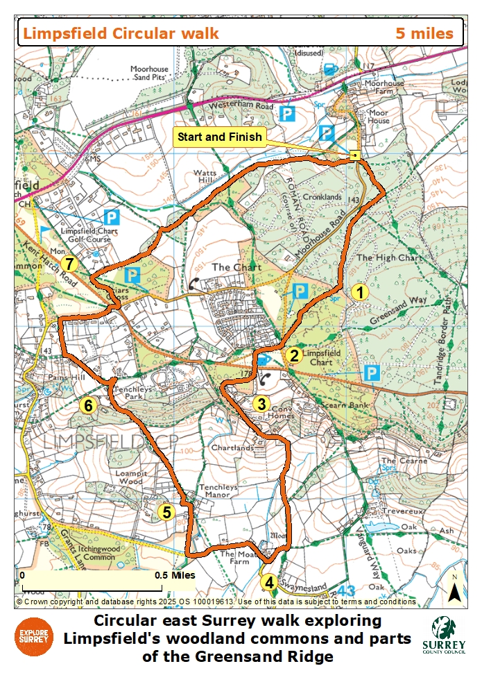
Map
The map shows the walk from the High Chart to cross Limpsfield Chart and Common reaching Tally Road near the Carpenters Arms pub. Walk through rural residential areas and pass Moat Farm and Tenchley Manor. Cross Kent Hatch Road to reach the outskirts of Limpsfield Golf course. From here walk through woodland and pastures to return to the start point of the walk. Select the map of the route below to open a more detailed version in a new window that can be printed if necessary, using your browser print tool. Alternatively you can save the image to your mobile device for reference on your walk.