About the walk
A circular walk from Reigate Heath with views across the North Downs, passing Reigate Heath windmill, Wonham Mill and pillboxes built during the Second World War.

Route details
- Start and end address: Reigate Heath bus stop on A25 junction at Flanchford Road
- Car park postcode: RH2 8AB
- Difficulty: moderate terrain
- Distance: 4.5 miles, 7 kilometres
- Type of walk: circular
- Approximate time: 2 hours
- Accessibility: several kissing gates and stiles. Parts of the route can be muddy
- Facilities: The Black Horse and The Skimmington Castle pubs near the start of the walk
- Ordnance Survey Map: Explorer 146 Dorking, Box Hill and Reigate
Getting there
By bus: bus route 32 stops at the Reigate Heath bus stop alongside the junction with Flanchford Road. Take a look at Surrey bus timetables for details of public transport.
By car: there are car parks either side of Flanchford Road half a mile south of the A25. From the car park on the south side of Flanchford Road join the wide sandy track running along behind the car park and turn right to start the walk.
Points of interest
At various points on this walk, you will be on the Greensand Way. This long distance route starts in Haslemere and ends at the coast in Kent. The Surrey section is 55 miles long and takes the walker along tranquil, often hilly, paths with great views to be enjoyed.
The house on Trumpets Hill (at walk stage 4) was constructed in 1901 and is formerly the site of a windmill, one of six mills in the area in the nineteenth century. Only two now remain, the one you will pass at Reigate Heath and the other on Wray Common. The existing windmill on Reigate Heath dates from 1765 and is built on Galley Hill, so called because it was the site of a gallows where highwaymen were hanged. The mill worked for about 100 years and in 1880 was converted to a chapel, which still holds services today.
The whole area around the River Mole is littered with pillboxes, which were fortified gun placements built in the period during the Second World War when it was feared that a land invasion was imminent.
Wonham Manor and a water mill are shown on the Senex map of 1723. The mill was used to grind flour till 1930, during the Second World War it was used as a store by the Ministry of Food. It has now been converted into private houses.
Walk directions
This walk follows public footpaths and bridleways which cross private and public land. If you come across a problem on a public right of way, please notify us on our online fault reporting form.
For any feedback on this walk email us: countryside.bookings@surreycc.gov.uk.
Stages from start point to end of walk
Please follow the Countryside Code.
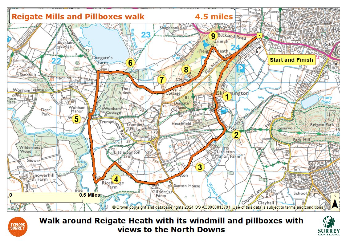
The numbers of each stage of the walk correspond with the points shown on the map.
- Start to Bonnys Road
- Stage 1: Bonnys Road to Littleton Manor junction
- Stage 2: Littleton Manor junction to Littleton stile
- Stage 3: Littleton stile to Trumpets Hill view crossroads
- Stage 4: Trumpets Hill view crossroads to Wonham Mill
- Stage 5: Wonham Mill to gate by stream
- Stage 6: Gate by stream to golf course
- Stage 7: Golf course to viewpoint
- Stage 8: Viewpoint to crest of ridge
- Stage 9: Crest of ridge to end
Start to Bonnys Road
The walk starts from the bus stop on the junction between the A25 Buckland Road and Flanchford Road. Walk down Flanchford Road using the left-hand pavement. Where the pavement ends by the entrance to Heath Church walk straight ahead on the narrow grass verge for a further 40 metres then turn left down the signed public bridleway. Follow this path through the edge of the woodland passing the south side of Flanchford Road car park on the right. After 250 metres you will arrive at the edge of the golf course. Follow the track straight ahead across the course, look out for the tee on the left and the fairway on the right. Turn right to join a vehicle track and continue to reach a T-junction with the road, Bonnys Road, with a flint house Old School House opposite.
Stage 1. Bonnys Road to Littleton Manor junction
Turn left along the road and then turn immediately right towards The Skimmington Castle pub. After just a few paces turn left to join the signed bridleway leading you through the trees, part of the Greensand Way. The path leads you past the pub on the right and then down past horse paddocks on the right. At this point there are views to Littleton Manor Farm on the right and beyond to the Weald. You will arrive at a junction of paths within the paddocks complex of Littleton Manor Farm.
Stage 2. Littleton Manor junction to Littleton stile
Take the path to the right passing through the white gate ignoring the sharp right turn over the stile. Follow the driveway towards Littleton Manor Farm and after passing the large barn on the right turn right onto the track leading you through a gateway. Continue on this track between the fence on the right and the hedge on the left for 350 metres passing the farmhouse on your left. Keep straight ahead at the crossroads of tracks continuing between paddocks. Where the track bends sharp right go straight ahead to cross the stile into a paddock.
Stage 3. Littleton stile to Trumpets Hill view crossroads
Cross the field diagonally left to reach the far left corner. Go over the stile and walk ahead on the fenced path leading you to a crossroads with Flanchford Road. Cross over the road and go along the track opposite signed as a byway, enjoy the excellent view of Box Hill and the North Downs on the right. Follow the track ahead leading you past the 16th century Gilberts Farm on the left. Continue for a further 500 metres to reach a signed crossroads of paths.
Stage 4. Trumpets Hill view crossroads to Wonham Mill
Follow the main track which bends round to the left keeping the woods on the left and a field on the right. After 275 metres you will reach the 16th century Ricebridge Farm. Keep left here to pass the farm on the right. At the end of garden on the right cross the stile directly ahead beside a pair of wide gates to enter a field. Turn right and follow the right-hand field boundary. This field edge path leads you between a pillbox on the left and the hedge on right.
At the end of the first field the path leads you over a stream with the River Mole on the left. Keep straight ahead on the path which follows the left-hand edge of this next field. Pass another pillbox on the left and a few paces later turn right through a kissing gate. Cross this field at to reach the wooden kissing gate alongside the river. Go through this gate and follow the path which leads you over a footbridge to reach the road opposite Wonham Mill.
Stage 5. Wonham Mill to gate by stream
Cross over the road and turn left along the pavement walking uphill. Immediately after the mill's parking area turn right onto the signed footpath. Follow this surfaced footpath ahead and just before you reach the pond turn left onto another signed footpath. Pass the pond on the right and you will come to a stile ahead. Cross this stile and walk directly ahead across the paddock heading for the farm buildings visible in the distance. Continue in the same direction crossing two further stiles along the way. Follow the narrow path with a hedge on the left and you will arrive at a T-junction with the road alongside Dungates Farm.
Turn right along the lane passing The Granary on the right and then some stables on the left. Keep ahead on the track with a tall hedge on the left. The track, part of the Greensand Way, leads you into a small section of woodland with a wide stream running on the left. You will reach a point where the path divides in two, take the righthand path passing through a gateway.
Stage 6. Gate by stream to golf course
Follow the obvious track through the open field and at the far end pass through the right-hand of the two gateways to join a fenced section of track. The track leads you between bollards with the golf course visible on the right. You will arrive at a T-junction at the edge of Reigate Heath golf course with Ivy Cottage on the left and views of a windmill ahead.
Stage 7. Golf course to viewpoint
The next sections of path cross the golf course, walk straight ahead across the fairway towards the windmill. Walk up the hill on the sandy path with the windmill to your left. Towards the top of the hill you will find a bench on the left, a perfect spot to pause and enjoy the panoramic views.
Stage 8. Viewpoint to crest of ridge
At the top of the hill you will come to a T-junction with a track. Turn left and walk through the car park passing the clubhouse on your left. Pass two cottages on your left ignoring the first path on the right. Where the track bends left turn right immediately after the first mirror-topped post. Follow this slightly sunken gravel path bending left along the edge of a fairway. Turn left and walk along the edge of the fairway following the edge of the trees on your left. Walk straight ahead to join the sandy path which leads you up the ridge. Towards the top of the ridge you will find the 5th tee on the right with two benches immediately behind it.
Stage 9. Crest of ridge to end
Turn right to join the wide sandy path leading you downhill to reach the car park on the north side of Flanchford Road. Turn left on the grass path which runs alongside the road and leads you directly back to the bus stop where the walk ends.
Map
The map shows the walk from Reigate Heath golf course near the A25, continuing across fields and farmland until it reaches the River Mole, pillboxes and Wonham Mill. It then goes back via a different part of the same golf course past the windmill to return to the starting point of the walk. Select the map of the route below to open a more detailed version in a new window that can be printed if necessary, using your browser print tool. Alternatively you can save the image to your mobile device for reference on your walk.