About the walk
An enjoyable circular walk from Woldingham station. Woldingham sits in the Surrey Hills National Landscape and is surrounded by steep hills and sweeping valleys with great views.

Route details
- Start and end address: Woldingham railway station
- Car park postcode: CR3 7LT
- Difficulty: challenging terrain
- Distance: 3.5 miles, 5.5 kilometres
- Type of walk: circular
- Approximate time: 1.5 hours
- Accessibility: some steps, hills and climbs as well as quiet road walking
- Facilities: there are toilets at the station, village shops along Station Road and a garden centre near walk stage 5
- Ordnance Survey Map: Explorer 146 Dorking, Box Hill and Reigate
Getting there
By train: trains serving Woldingham station are run by Southern railways, check their website for timetables.
By bus: take a look at Surrey bus timetables for details of public transport.
By car: there is a pay and display car park at the station, a district council pay and display car park on Woldingham Road near the station, plus limited parking along Church Road adjacent to the railway.
Points of Interest
Woldingham Garden Village was originally built at the beginning of the First World War to house the Public Schools Battalion of the Middlesex Regiment. As war casualties mounted, it was converted into a convalescent camp. The founder of the Garden Village was Henry Fuller Morriss who was once the Mayor of Bermondsey. He bought the camp just after the war for about £10,000. Small properties were badly wanted as 'Homes for Heroes' and many of the buildings were converted into bungalows, a number of these are still standing today.
The Marden Park estate was established in the middle of the 17th century, when a wealthy London banker and Lord Mayor of London Sir Robert Clayton decided to build a luxurious country house for himself. A wealthy stockbroker, Sir Walpole Lloyd Greenwell, bought the Marden Park estate from the Claytons in 1906, he and his son Sir Bernard kept what was considered to be the finest collection of racehorses in the county. Marden Park Farm was built for their stud of renowned shire horses. After the Second World War the estate was split up, Marden Park Farm is now private housing and business units and Marden Park House is now Woldingham School.
Walk directions
This walk follows public footpaths and bridleways which cross private and public land. If you come across a problem on a public right of way, please notify us on our online fault reporting form.
For any feedback on this walk email us: countryside.bookings@surreycc.gov.uk.
Stages from start point through to end of walk
Please follow the Countryside Code.
The numbers of each stage of the walk correspond with the points shown on the map.
- Start to Station Road
- Stage 1: Station Road to steps junction
- Stage 2: Steps junction to Woldingham Garden village
- Stage 3: Woldingham Garden village to High Shaw
- Stage 4: High Shaw to Woldingham Road
- Stage 5: Woldingham Road to railway bridge
- Stage 6: Railway bridge to Marden Park junction
- Stage 7: Marden Park junction to end
Start to Station Road
Leave the front entrance of the ticket office into the station car park. Come out of the car park through the vehicle entrance and walk straight ahead uphill using the right-hand pavement of Station Road. Immediately after passing the electricity substation on the right turn right up the steps. At the top keep left and follow the tarmac path uphill to reach a junction with a road. Turn left and continue through the residential estate. At the end of Park View Road turn left for a short downhill path to reach a T-junction with Station Road.
Stage 1. Station Road to steps junction
Cross over the road and turn right along the pavement. Immediately after the property called Sunnyside on the left, turn left to join a narrow footpath which leads you downhill between gardens. At the end you will come to a road and you will see a choice of two footpaths opposite. Take the left-hand path called Madeira Walk and follow this for 850 metres passing first between houses and then through a section of woodland. The open area near to the path is a remnant of chalk grassland, which has a rich variety of plants. Further along, where you come out from the trees, there are excellent views to the left towards London. You are looking at the slope of the North Downs and across the Caterham Valley. You will come to a small section of fencing at a signed junction of paths with some small steps visible ahead.
Stage 2. Steps junction to Woldingham Garden village
Keep slightly right here to walk up the steps. Keep straight ahead on the path between fences and you will arrive at a crossroads with a narrow tarmac lane. Do not take the footpath which continues opposite, instead turn right along the residential road.
Stage 3. Woldingham Garden village to High Shaw
You are now in Woldingham Garden village. Follow the main tarmac road around the village bending left, then left again, then right, then left, ignoring any footpaths signed to the sides. After passing property No. 1 you will come to a T-junction with Hilltop Walk. Turn right and follow the road for just 90 metres to draw level with the property High Shaw on the left.
Stage 4. High Shaw to Woldingham Road
Turn right here to join the signed public bridleway which leads you downhill with a fence on the left. The bridleway becomes a tarmac access lane continuing downhill between houses. At the bottom you will come to a junction with a road with the golf course visible ahead. Turn sharp left along Park Ley Road for just a short distance of 40 metres then turn right down the bridleway to reach a T-junction with Woldingham Road.
Stage 5. Woldingham Road to railway bridge
Turn left along the pavement for just a few paces then cross the road to turn right onto the bridleway signed to Gatwick and Redhill. You will arrive at a T-junction with the quiet tarmac access drive for Woldingham School. Turn left along this. The valley you are now walking through is called Marden Park. Follow the driveway as it bends right to reach a railway bridge, pass under the bridge and stay on the drive as it bends left.
Stage 6. Railway bridge to Marden Park junction
Continue along the driveway and you will pass the old lodge property on the left with the station buildings visible behind this. Approximately 830 metres further along after the railway bridge take the first bridleway signed on the left which leads you towards Marden Park Farm. You will come to a property called Shires ahead. Go through the gap just to the right of this property and follow the path alongside the hedge. Continue along the paved section between the converted stables and barns to reach a T-junction.
Stage 7. Marden Park junction to end
Turn left and follow the main track passing between farm buildings and fenced fields. The lane bends right, leading you over the railway bridge and then left to continue running parallel to the rail line down to the left. At the end of Church Road you will come to Woldingham rail station on the left where the walk ends.
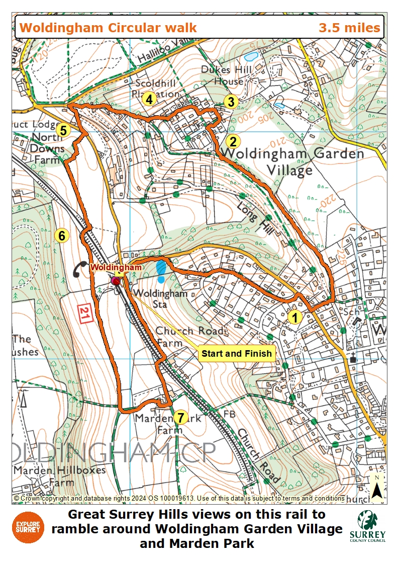
Map
The map shows the walk from Woldingham station into the residential estate crossing Station Road and Long Hill to join a path with views to the right. Then it goes through Woldingham Garden Village and eventually out to Woldingham Road. Cross the railway line and continue with the station on the left into the Marden Park estate, now Woldingham School. After that it re-crosses the railway to return to the station where the walk began. Select the map of the route below to open a more detailed version in a new window that can be printed if necessary, using your browser print tool. Alternatively you can save the image to your mobile device for reference on your walk.