About the walk
A 5.5 mile circular walk taking in the countryside around Chessington. As you walk this route through designated nature reserves it may come as a surprise how much attractive countryside there is close to the London and Surrey border.

Route details
- Start and end address: Horton Country Park, Epsom
- Car park postcode: KT19 8GW
- Difficulty: moderate terrain
- Distance: 5.5 miles, 8.5 kilometres
- Type of walk: circular
- Approximate time: 3 hours
- Accessibility: steps, kissing gates and one stile. Some road walking.
- Facilities: public toilets and a picnic site alongside the car park at the start of the walk
- Ordnance Survey Map: Explorer 161 London South
Getting there
By car: free car park accessed off Horton Lane and marked with brown tourism signs. There is a 1.9cm height restriction barrier and the car park closes at dusk in winter and 9pm in the summer.
By train: If you are coming by train, adjust the walk to start and finish at Chessington South rail station (walk stage 2) which is served by both trains and buses.
By bus: Services E9 and E10 serve the area. Take a look at Surrey bus timetables for more detail.
Points of Interest
Horton Country Park was created in 1973 when 400 acres of land were purchased by Epsom and Ewell Borough Council from the Greater London Council, their predecessors had built five psychiatric hospitals in the area in the late 1800s and early 1900s. This land had been farmland which supplied both food and work for the hospital patients. Today the country park is a rural landscape of fields, hedgerows, woods and ponds of wildlife and historical value. It is a designated Local Nature Reserve (LNR) and has adopted the symbol of the green woodpecker, a common sight here.
Coal Tax Posts at walk stages 4 and 5. From late medieval times to 1890 the Corporation of the City of London had the right to levy a duty on coal brought into the city. This duty helped to pay for the rebuilding of St Paul's Cathedral and several other churches that were destroyed in the Great Fire of London in 1666. The 1861 London Coal and Wine Continuance Act enlarged the area for the collection of duties and over 200 coal tax posts including this one, were erected to mark the new boundary.
Ashtead Common National Nature Reserve (NNR), owned by the City of London was once the wasteland of the Manor of Ashtead and is steeped in history. The common holds NNR status for its oak pollards and the rare beetles associated with them.
Walk directions
This walk follows public footpaths and bridleways which cross private and public land. If you come across a problem on a public right of way, please notify us on our online fault reporting form.
For any feedback on this walk email us: countryside.bookings@surreycc.gov.uk.
Stages from start point through to end of walk
Please follow the Countryside Code.
The numbers of each stage of the walk correspond with the points shown on the map.
- Start at Horton Country Park to Bonesgate stream
- Stage 1: Bonesgate stream to Chessington South station
- Stage 2: Chessington South station to viewpoint
- Stage 3: Viewpoint to Chessington wood
- Stage 4: Chessington wood to Ashtead Common
- Stage 5: Ashtead Common to Stew ponds
- Stage 6: Stew ponds to Horton Country Park
Start at Horton Country Park to Bonesgate stream
In the car park stand with your back to the vehicle entrance with the toilet block on the right. Walk ahead along the tarmac lane and where this bears right keep straight ahead to join the footpath between trees, signed for the Thames Down Link and the Chessington Countryside Walk (CCW). You will be following CCW signposts for the full length of this route.
Through the trees to the right you will see the large barns of the equestrian centre within Horton Country Park. At the T-junction turn right and a few paces later keep straight ahead at the junction on the bridleway signed to Chessington. Keep straight ahead along this track passing the Polo Club car park to the right and horse paddocks to the left. Ignore the first signpost to the left, simply keep ahead between the fenced pastures where you may see donkeys grazing. Keep straight ahead until you come to a fork in the path. Take the left-hand branch signed to Chessington which will lead you to a crossroads. Go straight ahead on the narrow footpath between trees signed to Green Lane. Go through the kissing gate which leads you to the edge of a large crop field. Turn right along the right-hand field boundary and follow this as it swings left. In the far right-hand corner pass through the gap in the hedgerow alongside a disused stile and keep ahead along the right-hand edge of this next crop field. Follow the path ahead to reach a footbridge over a stream, Bonesgate Stream.
Stage 1: Bonesgate stream to Chessington South station
Cross the footbridge and follow the path steadily uphill with a fence on the left. At the top of the slope you will arrive at a T-junction at a residential lane, Green Lane. Cross over and turn left along the pavement until it ends then keep ahead with extreme care along the road edge for a few more metres. Just a few paces beyond the 30mph signs turn right up the steps to join the footpath signed to Garrison Lane. The path leads you between houses on the right and a golf course on the left. At the end of the path you will arrive at a T-junction with Garrison Lane. Turn left along the pavement and this will lead you past Chessington South station on the right. Soon afterwards use the pedestrian crossing to swap to the right-hand pavement.
Stage 2: Chessington South station to viewpoint
If you are starting the walk from Chessington South Station, leave the station onto Garrison Lane and turn right along the pavement.
Continue along Garrison Lane using the right-hand pavement. Pass the community college on the right and you will reach a T-junction with Kingston Road. Turn right along the pavement for just a few paces and then use the pedestrian crossing to cross Kingston Road. At the far side turn left along the pavement passing the junction with Garrison Lane from where you emerged on the left. Turn right into Barwell Lane signposted to Claygate.
Follow Barwell Lane taking care of any occasional traffic. The lane runs between tall hedges with houses to the right and sports fields to the left. Ignore the first bridleway to the right simply keep ahead between horse paddocks on each side. Just before the road bears right alongside Virginia Cottage on the right turn left through a gate into the site of Winey Hill. Please note there are horses grazing freely within this site so take care with dogs. Follow the path ahead and then swinging right up the hill. As you emerge from the trees keep straight ahead onto the brow of the ridge. Turn left along the brow of the ridge and you will come to a brick and flint plinth, marking the viewpoint on Winey Hill just before you reach a fenced pond ahead. Take a moment to enjoy the views towards the North Downs to the south and across the Thames Valley and London to the north.
Stage 3: Viewpoint to Chessington wood
With your back to the plinth facing the fenced pond, keep to the left of the pond and then walk straight ahead on the subtle path going steadily downhill. At the bottom pass through the kissing gate and join the fenced path with open fields and great views to the right. Through the fence on the left is the well-known Chessington World of Adventures. A little way along turn left onto the path signed to Leatherhead Road. You will come to a T-junction with the corner of the car park access lane within the adventure park, this can be very busy at times. Bear left to follow the access lane with the fence for the park running on the left. The lane leads you steadily downhill passing a series of parking fields on the right named after a variety of animals such as leopard, vulture and macaw. At the bottom of the slope you will come to a crossroads with a vehicle track. Go straight ahead passing a disused stile to join a grass footpath between trees. A stile leads you out to the pavement alongside Leatherhead Road.
Please note Leatherhead Road is very busy and fast so take extreme care here. Cross over the road using the central pedestrian island for your safety. Keep straight ahead on the public bridleway signed to Ashtead Common which leads you into Chessington wood.
Stage 4: Chessington wood to Ashtead Common
Follow the main path which swings steadily right which may be muddy. The path leads you across a footbridge, back over Bonesgate stream and on between lines of trees and hedgerows. This green track follows the line of a route that has been in use since at least 1495 and once an important link by horse and cart between Kingston and Leatherhead.
Towards the end of the path you will come to a junction of paths with a brick World War II Pillbox visible to the right, now converted to new use as a bat roost. Keep straight ahead for a few more metres and cross over the sleepers to reach a T-junction with Rushett Lane. Cross over with care, turn left for a few paces and then turn right through the gate to join the bridleway signed to Ashtead Common. Follow the obvious bridleway which crosses the crop field diagonally left. At the end of the first field turn sharp left and then right to continue across the second crop field. Follow this path directly ahead to reach the top of the field where a gate leads you into Ashtead Common, with a noticeboard ahead and a short white post on the left. This white cast iron post is a City of London coal duty boundary marker or coal tax post.
Stage 5: Ashtead Common to Stew Ponds
You are now on Ashtead Common, a National Nature Reserve owned by the City of London. With your back to the gate turn left along the bridleway signed to Epsom Common passing the coal tax post on the left. At the first crossroads keep straight ahead still signed to Epsom Common. At the second crossroads just after another coal tax post go straight ahead on the bridleway signed to Christchurch Road.
You are now within Epsom Common, a Local Nature Reserve bought by the council in the 1930s. Follow the path winding downhill and you will pass a pond on the right with a second larger pond behind this. The two ponds were constructed by the Abbots of Chertsey in the 12th century. The larger Great Pond was restored in the 1970s and the smaller pond is known as Stew Pond.
Stage 6: Stew Ponds to Horton Country Park
Keep straight ahead along the bridleway ignoring the first path on the left which only leads to a car park. Further along you will come to a signed junction with a vehicle barrier on the left. Walk left here on the bridleway signed as the Thames Down Link. The path leads you to a crossing over Rushett Lane. Cross with care and continue on the bridleway ahead signed to Horton Lane. Keep ahead past a couple of properties on the left and ignore the footpath signed to the right. Instead bear left on the sandy track, cross over the Noble Park housing estate entrance road and then bear left along the fenced bridleway, with the Noble Park grounds through the fence on the left.
Follow the path with the tall wire fence on the left and after 100m you will come to a signed junction. Turn right here on the path which still forms part of the Thames Down Link. The path winds along the right-hand edge of open rough fields. Cross over a small tarmac lane and continue on the woodland footpath opposite. Bear right to merge with a wider green track. Follow the track as it bends left signed to Chessington and then turn immediately right before the picnic field to reach Horton Country Park car park where the walk began.
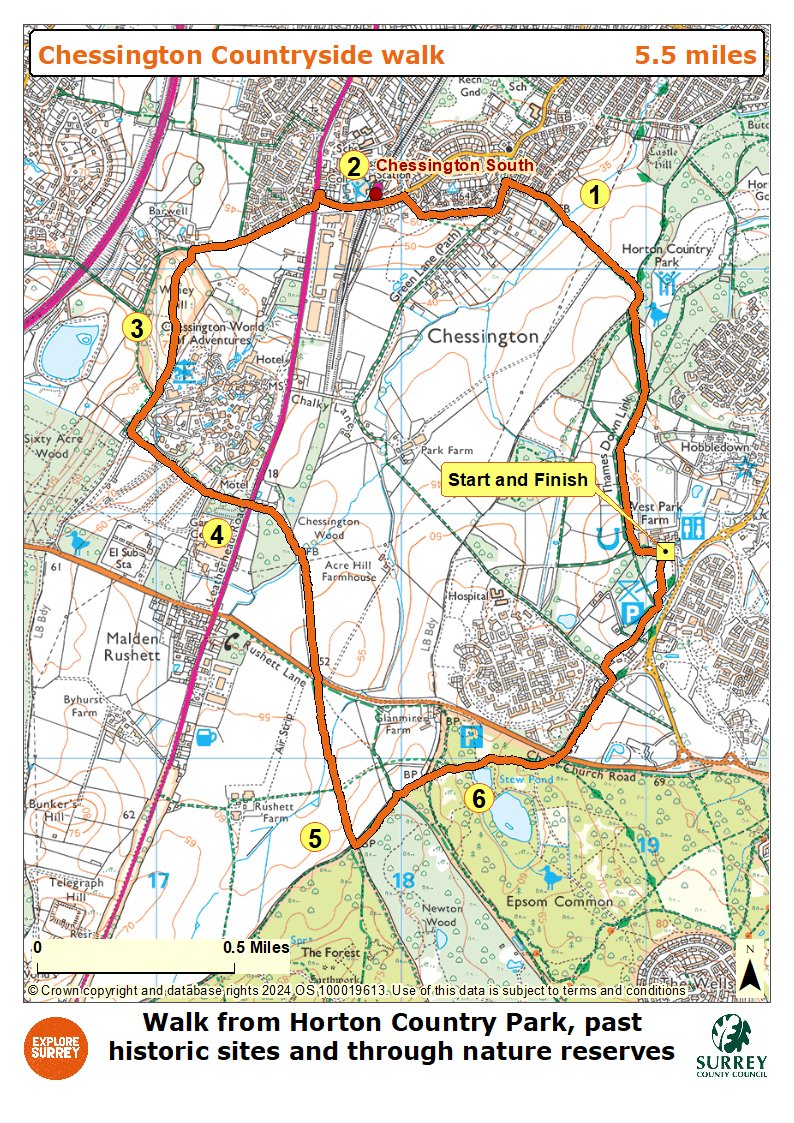
Map
The map shows the walk from Horton Country Park car park to the Bonesgate stream, past Chessington South station and then on to Winey Hill viewpoint. It then goes through Chessington wood to Ashtead Common and the stew ponds on Epsom Common, then back to Horton Country Park along the Thames Down Link. Select the map of the route below to open a more detailed version in a new window that can be printed if necessary, using your browser print tool. Alternatively you can save the image to your mobile device for reference on your walk.