About the walk
Explore the Surrey Hills, the Tillingbourne river valley and its villages, woodland and farmland on this 4.5 mile rail to ramble walk from Chilworth station.

Route details
- Start and end address: Chilworth railway station
- Car park postcode: GU5 9BG
- Difficulty: challenging terrain
- Distance: 4.5 miles (7 kilometres)
- Type of walk: circular rail to ramble
- Approximate time: 2.5 hours
- Accessibility: kissing gates and stiles
- Facilities: pubs and refreshment options in Chilworth, Albury and Shere
- Ordnance Survey Map: 145 Guildford and Farnham
Getting there
By train: the walk starts from Chilworth railway station. Frequent Great Western Railway (GWR) trains run on this North Downs line.
By car: there is no car parking available at the station. There is some street parking, check for parking restrictions and park with respect to nearby residents.
By bus: bus route 32 stops outside the station on the A248 through Chilworth. Take a look at Surrey bus timetables for details of public transport.
Points of Interest
The source of the Tillingbourne River is located north of Leith Hill. It then runs through the Surrey Hills villages of Friday Street, Abinger Hammer, Gomshall, Shere, Albury, Chilworth and Shalford, where it joins the River Wey. The river has a long history powering many mills in the area. The Tillingbourne valley was a major industrial area due to its proximity to London and ease of transport via the river Wey which flows into the Thames. Some 24 mill sites have been identified along the course of the Tillingbourne, used for such diverse industries as gunpowder, paper-making for banknotes, iron-working, tanning and pumping water, as well as more conventional flour and malt milling. Take a look at the Surrey Hills' Tillingbourne Tales Trails for further information or visit Shere museum for their permanent exhibition.
Chilworth Gunpowder Mills is classified as a Scheduled Ancient Monument (SAM). The buildings date from the 1600s and were operational from the 1620s until 1920. They were most extensive and productive in the 17th century and from the 1880s to the end of World War I. Traditional black gunpowder was made throughout its history with modern explosives, such as cordite, manufactured in the last decades of its operation. Guildford Borough Council looks after the site and has downloadable information leaflets on its website.
Walk directions
This walk follows public footpaths and bridleways which cross private and public land. If you come across a problem on a public right of way, please notify us on our online fault reporting form.
For any feedback on this walk email us: countryside.bookings@surreycc.gov.uk.
Stages from start point through to end of walk
Please follow the Countryside Code.
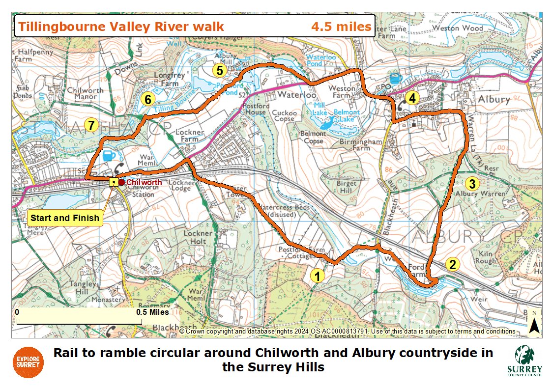
The numbers of each stage of the walk correspond with the points shown on the map.
- Start to Stage 1: Postford Farm cottage
- Stage 2: Postford Farm cottages to Little Ford Farmhouse
- Stage 3: Little Ford Farmhouse to sandy track crossroads
- Stage 4: Sandy track crossroads to A248 in Albury
- Stage 5: Albury village to sluice bridge
- Stage 6: Sluice bridge to Lockner Farm track
- Stage 7: Lockner Farm track to end
Start to Stage 1. Postford Farm cottages
Exit Chilworth railway station alongside the phone box to reach the bus shelter on the triangular green. Turn right along pavement for the A248 and follow it for 470 metres. As you draw level with Longfrey Farm on the left, turn right into Dorking Road signed as the Downs Link. Follow the lane over the railway bridge and immediately afterwards turn left through the gap in the white fencing passing the small cottage on the left. Walk ahead on this grass path which soon runs between fences. Cross the stile into a horse paddock and walk diagonally right to reach the far right-hand corner. Pass through the kissing gate and follow the path which bends right, with a hedge on the right. Where the hedge bends away keep straight ahead on the path along the line of the bank across the field lined with electric fencing. The path becomes a track following a line of trees on the left. Cross a stile or use the gate beside it to pass Postford Farm cottages on the right.
Stage 2. Postford Farm cottages to Little Ford Farmhouse
Keep straight ahead on the main track ignoring the footpath signed to the right leading you downhill past the stables on the left. Continue across the stream and stay on the main track which bends right past a barn and stables. Walk ahead along the tarmac track to reach a T-junction with a sunken lane. Turn right and then immediately left over a stile to enter a pasture. Follow the obvious grass track ahead with a grass bank immediately on the left and a stream across to the right. The waters of The Bourne stream, a tributary of the Tillingbourne, are used for growing watercress. You will pass Little Ford Farmhouse on the left, a timber-framed building dating from the sixteenth century. Immediately afterwards pass through the kissing gate ahead to reach a junction with a stone vehicle track.
Stage 3. Little Ford Farmhouse to sandy track crossroads
Turn left through the gateway into the courtyard and then turn immediately left again through another gateway to join a stone track passing the farmhouse on the left. Go through the gate and follow the path up through a section of old coppiced trees. As you come out from these trees continue ahead for just a short distance to reach the white gates of the railway crossing.
Please note: This railway crossing is unsignalled so take extreme care, look and listen for trains before you cross
At the far side follow the path diagonally across the field, passing to the right of a small clump of trees. Continue in the same direction towards the woodland ahead. Just before the end of the field a fence begins on the right. A few paces along this turn right over a stile to enter the woodland. Walk straight ahead on the narrow woodland path which soon widens to become a track to reach a crossroads. Keep straight ahead passing a fenced clearing of trees on the right. At the top of the hill where the fence ends you will come to a crossroads with a sandy track.
Stage 4. Sandy track crossroads to A248 in Albury
Keep straight ahead on the narrow path soon following a wire fence on the left. The path arrives at a T-junction with a sunken path, Warren Lane. Turn left and you will pass between farm gates each side providing great viewpoints. Continue down the sunken path and turn left at the junction. The track will lead you to the end of a residential road, Church Lane. Keep straight ahead along this lane and further along you will pass a stone memorial for Louisa Duchess of Northumberland on the right and Albury Church on the left. Walk straight ahead passing the village bowling green on the right. Follow the road as it bends right to reach a T-junction with the A248 at the centre of Albury village. The Drummond Arms pub is visible just to the right.
Stage 5. Albury village to sluice bridge
Turn left along the road. Pass Weston Farm and then pass Water Lane and Guildford Lane on the right. Stay on the pavement as it goes uphill to the left. Opposite Vale End Fisheries on the left you will see a choice of two footpaths on the right. Cross over the road and take the second of the footpaths passing through a staggered barrier. Follow the path with Waterloo Pond on the right and a stream on the left. You will come to a T-junction with a tarmac drive, turn left along this. You will pass Postford Mill Pond on the left and a former mill building on the right, now converted into residential and office buildings. Historically these buildings were powder, paper and corn mills relying upon the Tillingbourne river for water power. Immediately after the mill on the right you will come to the bridge over a millpond sluice.
Stage 6. Sluice bridge to Lockner Farm track
Cross the bridge then keep right to join the signed public footpath which leads you between fences. Follow this narrow path with a house on the right and fenced horse paddocks on the left and it will lead you past a disused stile. Keep ahead on the fenced path between fields. You will come to a sleeper bridge and stile ahead. Cross the bridge and stile to enter the horse paddock. Walk ahead in the same direction across this field. At the far side cross the stile to enter a smaller paddock. Keep in the same direction across this field and cross the stile opposite to reach a junction with Lockner Farm track.
Stage 7. Lockner Farm track to end
Turn right crossing the bridge and then turn left through the staggered barrier to enter the site of Chilworth Gunpowder Mills. You will pass an information board on the right which gives more information about the mills. Continue ahead with the canal on the left passing the old buildings on the right. Beyond the building remains follow the path as it bends right passing a bench on the left, then continue straight ahead. You will come to a picnic area on the right. Immediately alongside the picnic area turn left and follow this footpath (known as Vera's Path which can be muddy) across the footbridge. You will see the remains of an old rail track across the stream on the left. The path leads you out to a T-junction in Chilworth village with the school on your left. Turn left along the pavement and you will pass the Percy Arms pub on the left and then come to Chilworth rail station on the right where the walk ends.
Map
The map shows the walk from Chilworth rail station to cross the Downs Link path, then continuing along the river towards Albury village. It then goes along Warren Lane to reach the buildings at Postford Mill, Lockner Farm and the entrance into Chilworth Gunpowder Mills. Halfway through the mills join Vera's Path back to Chilworth station. Select the map of the route below to open a larger version in a new window, that can be printed if necessary, using your browser print tool with landscape selected. Alternatively, you can save the image to your mobile device, for reference on your walk.