About the walk
A hilly circular walk from Cobham, taking you through beautiful countryside around Downside, the River Mole and Chatley Heath, discovering local history and wildlife.

Route details
- Start and end address: Hollyhedge Road pay and display car park
- Car Park postcode: KT11 3DQ
- Difficulty: challenging terrain
- Distance: 6 miles, 10 kilometres
- Type of walk: circular
- Approximate time: 3 hours
- Accessibility: multiple kissing gates and stiles, some walking through fields and on country roads
- Facilities: many refreshment options in Cobham, picnic benches at the semaphore tower at point 3, The Black Swan pub is near point 4.
- Ordnance Survey Map: Explorer 146 Dorking, Box Hill and Reigate and Explorer 145 Guildford and Farnham
Getting there
By car: Hollyhedge Road pay and display car park is just off Downside Bridge Road, Cobham
By bus: There are regular bus services to Cobham High Street near to the start point from Kingston, Esher, Epsom and Weybridge. Take a look at Surrey bus timetables for details of public transport.
Points of Interest
Chatley Heath Semaphore Tower was constructed with a semaphore mast on top, as part of a chain of 15 semaphores, which were used to relay messages between the Admiralty in London and Portsmouth Dockyard. The Tower is now owned by The Landmark Trust and available to rent for holidays.
Legend has it that the River Mole is so-called because it disappears underground into the chalk near Dorking during dry weather. You may be lucky enough to spot the blue flash of a kingfisher flying past.
Walk directions
This walk follows public footpaths and bridleways which cross private and public land. If you come across a problem on a public right of way, please notify us on our online fault reporting form.
For any feedback on this walk email us: countryside.bookings@surreycc.gov.uk.
Stages from start point through to end of walk
Please follow the Countryside Code.
The numbers of each stage of the walk correspond with the points shown on the map.
- Start to Downside bridge
- Stage 1: Downside bridge to Pointers Road
- Stage 2: Pointers Road to Semaphore tower
- Stage 3: Semaphore tower to Ockham Lane
- Stage 4: Ockham Lane to Old Oak common
- Stage 5: Old Oak common to Pondtail farm
- Stage 6: Pondtail farm to end
Start to Downside bridge
Leave the car park via the vehicle exit to Downside Bridge Road, the longest side of the car park. Turn left along the pavement passing playing fields and allotments to the right. Follow the pavement for some distance crossing over side roads and passing St Andrew's Church on the left. Follow the road as it bends right and then left to reach Downside Bridge, a bridge over the River Mole.
Stage 1: Downside bridge to Pointers Road
Please note: You may come across cattle in some of the fields in this section.
Cross the river bridge and before you reach the first house on the right, cross over the road to turn right over a stile signed as a public footpath. Walk straight ahead across the centre of the field passing just to the right of the large tree in the field centre. At the far side pass through a gap in the hedge and continue in the same direction across the second field, passing a row of old oak trees on the right.
Cross the wooden boardwalk and stile to enter the third field and walk across this pasture. Across to the left are three ancient oaks with huge trunks, they may be more than 300 years old. Cross the stile into the fourth field and follow the right-hand boundary with the River Mole running on the right. In the field corner you will come to a footbridge with stiles at each end. Cross this to enter the fifth field, a large horse paddock likely to have horses within. Cross the paddock diagonally left crossing a stile in the centre and continuing in the same direction to reach the stile on the far boundary. This stile leads you out to a T-junction with the road, Pointers Road.
Stage 2: Pointers Road to Semaphore tower
Turn right along the road taking care of any traffic. After a quarter of a mile you will pass the ornate gateway for The Lodge on the left. Continue for a further 150 yards then turn left onto a tarmac track signed as a public bridleway entering Chatley Heath. Follow the track ahead which leads you over the M25 and immediately afterwards, turn right onto the signed public bridleway to Old Lane. The woodland path bends left and then leads you quite steeply uphill. At the very top of the hill you will come to a junction with a tarmac lane. Turn right along this and follow it as it bends right to reach Chatley Semaphore Tower.
Stage 3: Semaphore tower to Ockham Lane
Return back the way you came along the tarmac lane. Just before the lane bends left turn right onto the bridleway and continue ahead for some distance. Across to the right is Chatley Heath. At the bottom of the slope you will come to a crossroads, turn left here onto the public bridleway signed to Ockham Lane until you reach a junction, continue straight ahead here. Keep right where the path splits in two and follow the bridleway out of the woodland to reach the end of a tarmacked access lane. Walk straight ahead along the lane passing Hasley House and Ockham Manor on the right. Through the fence to the left are the grounds of Hatchford Park and soon afterwards, the house itself will come into view. Follow the access lane all the way to the end where it meets a T-junction with Ockham Lane.
Stage 4: Ockham Lane to Old Oak common
Turn left along Ockham Lane for just 100 yards passing the entrance drive for Hatchford House on the right. Just before the entrance drive look out for and turn right up a small flight of steps and go through the kissing gate. Follow the narrow path between property fences and you will come out to a quiet access lane. Keep straight ahead along this passing several horse paddocks. Take time to enjoy the expansive views ahead.
At the bottom of the slope where the access lane bends left to Orchard Farm, keep straight ahead on the concrete track passing stables on the right. Cross the stile ahead and follow the narrow, electric-fenced path between open fields. Cross the next stile and continue on the path now with a tall fence on the right. The path winds between garden fences and then crosses a timber footbridge to reach the corner of the front garden of May Cottage. Turn left along the hedge line and then continue ahead to cross the stile out to the road. Turn left along the road and at the junction, keep right signed to Horsley Road. Follow the lane past cottages and continue to the end with Yew Tree Cottage ahead. Turn right over the stile half-hidden in the hedge and then turn left to follow the hedge line on the left. Where the hedge on the left is set back, turn right towards the single oak tree in the field centre. As you draw level with the tree, stay on the footpath which bends left and leads you to another wooden footbridge at the edge of a small section of woodland, known as Old Oak Common.
Stage 5: Old Oak common to Pondtail farm
Cross the wooden footbridge and follow the narrow path through the woodland. Some way along cross the stile ahead and continue on the woodland path. You will come out of the woodland at the edge of a large open field. Do not go ahead as directed by the misleading signpost, instead turn left following the woodland edge. This will lead you to another stile.
Please note: these next pastures are likely to be holding sheep or horses. Go over the stile and walk straight ahead passing a pond on the left. Cross the stile into the second pasture and walk directly ahead following the hedge on the left. Keep in the same direction across three more stiles with solar panels on your right-hand side. After the third stile keep ahead along the field-edge track with electric fencing on the right. Half-way along the field you will come to a junction with a track to the right.
Turn right here and follow the track which soon runs with a hedge on the left and horse paddocks on the right. Stay on the track as it bends right, running along the top of the horse paddocks, you will hear the noise of the M25 on the other side of the left-hand hedge. Continue just as far as the bridge over the M25 on the left and then turn left through the metal gate to cross this bridge signed to Chilbrook Farm. At the end of the bridge you will be faced with a locked gate ahead. Turn right through the kissing gate and then turn immediately left to follow the hedge . After just a few paces pass through the kissing gate on the left to reach the concrete track once again. Cross the track diagonally right to reach another kissing gate. Go through this and then turn right along the grass track signed to Chilbrook Farm. At the end of the grass track a stile leads you out to the concrete access drive for Pondtail Farm.
Stage 6: Pondtail farm to end
Turn right and follow the surfaced access track passing a small pond on the right. At the end of the drive pass through the small wooden gate to reach a T-junction with Chilbrook Road. Turn left along the road passing a row of cottages on the left. Follow the road for just 300 yards where you will reach a chevron sign marking a left-hand bend. Leave the road here and keep straight ahead on the gravel drive for Chilbrook Farm. Just before you reach the first farm building turn right through a kissing gate signed as a public footpath. Keep straight ahead along the left-hand edge of this large crop field. At the end of the field a final stile leads you out to the grass verge with no pavement alongside Downside Bridge Road. Take care when crossing over the road and turn left along the pavement.
Follow the pavement for some distance heading back towards Cobham. The pavement will lead you past the entrance for Cobham Park on the right and then on to reach Downside Bridge. From this point you will be retracing your steps back to the start point. Follow the right-hand pavement over the bridge then past the church and on to reach the car park where the walk began and now ends.
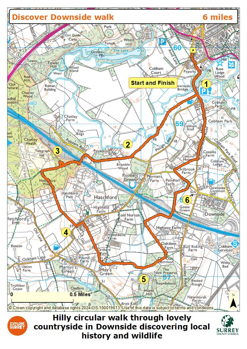
Map
The map shows the walk from the start to Downside Bridge then to Pointers Road, crossing the M25 to reach the Semaphore tower. Pass Hatchford Park to reach Ockham Lane, across Old Oak Common, across another bridge over the M25 to Pondtail Farm and to the end of the walk. Select the map of the route below to open a more detailed version in a new window that can be printed if necessary, using your browser print tool. Alternatively you can save the image to your mobile device for reference on your walk.