About the walk
A 7.5 mile circular walk with many historic points of interest, exploring the woodlands and open spaces of East and West Horsley and Effingham, including the Sheepleas and other woodland.

Route details
- Start and end address: Horsley railway station, parking charges apply
- Car park postcode: KT24 6QX
- Difficulty: challenging terrain
- Distance: 7.5 miles, 12 kilometres
- Type of walk: circular
- Approximate time: 4 hours
- Accessibility: some hills, gates, staggered barriers and two kissing gates
- Facilities: East Horsley shops are near the station. The Barley Mow pub is near point 8 of the walk.
- Ordnance Survey Map: Explorer 145 Guildford and Farnham and 146 Dorking, Box Hill and Reigate
Getting there
By train: the walk starts and finishes from Horsley railway station in East Horsley which has its own car park, charges apply.
By bus: bus route 478 stops at East Horsley station.
By car: there are public car parks in East Horsley village. Charges apply.
Points of interest
At walk stage 3 you will see the remains of a beautiful old brick and flint wall, the trademark style of the first Earl of Lovelace. The wall is the boundary for Horsley Park, the estate and manor house built in the late 1700s for the distiller and banker, William Currie. The first Earl of Lovelace, William King, bought the estate in 1840 and spent the next 25 years extensively remodelling it. Few elements escaped his attention, either being encased in or rebuilt in his signature decorative brick and flint style. Today the mansion is used as a hotel and conference centre.
The route also takes you past a number of the beautiful brick and flint bridges built by Lord Lovelace in the 1800s, constructed by workers on the Lovelace estate. Lord Lovelace was an enthusiastic forester and so that his workers could ride through the woods and extract timber on horse-drawn carts, he embarked on a programme of bridge building. Altogether fifteen horseshoe-shaped bridges were built (of which ten remain today in various states of decay), ranging in size from about six feet wide at Meadow Platt to eighteen feet wide at Dorking Arch, which crosses the road leading to Ranmore Common.
Sheepleas is a mosaic of woodland and open grassland. Some of the woods have been here for at least 400 years and are classified as ancient woodland, with beech, oak, field maple and wild cherry trees commonly found. The grasslands are rich in plants that thrive on chalky soil, like marjoram and wild orchids, supporting more than 30 species of butterflies. There are many paths with views to the London skyline in the distance.
At walk stage 7 you will be near the ornate Grade 1 listed red brick West Horsley Place, owned in the late 1640s by Carew Raleigh, the youngest son of Sir Walter Raleigh. This old manor house retains much of its medieval timber-framed construction although inside it has undergone renovation. The grounds are now a thriving arts location and home to Grange Park Opera house.
Walk directions
This walk follows public footpaths and bridleways which cross private and public land. If you come across a problem on a public right of way, please notify us on our online fault reporting form.
For any feedback on this walk email us: countryside.bookings@surreycc.gov.uk.
Stages from start point through to end of walk
Please follow the Countryside Code.
The numbers of each stage of the walk correspond with the points shown on the map.
- Stage 1: Start to Old London Road
- Stage 2: Old London Road to Orestan Lane
- Stage 3: Orestan Lane to Guildford Road
- Stage 4: Guildford Road to Crocknorth Farm
- Stage 5: Crocknorth Farm to Green Dene
- Stage 6: Green Dene to Millenium Viewpoint, Sheepleas
- Stage 7: Millennium Viewpoint to St Mary's Church
- Stage 8: The Street to end of walk
Stage 1: Start to Old London Road
Leave Horsley railway station via the main exit on Platform 2. Turn right along the pavement which leads you down the station's access road. Just after the first stretch of terraced houses on your left, turn left onto the tarmac public footpath by a sign for Thornleas Place. Follow this tarmac path uphill between houses. You will arrive at a residential road alongside a large green.
Go straight ahead passing the green on your left. Beyond the green keep directly ahead on the quiet lane, Cobham Way, between houses. At the end pass alongside the vehicle gate to reach a junction with the main road. Cross over turn left along the pavement and then take the first right into Norrels Drive, signed as a public footpath. Follow this quiet private road and part way along you will come to a signpost marking a crossroads of paths, just before you reach a pair of brick and flint old gatehouse properties called Norrels Lodge North and South. Turn left to join the footpath following the line of the lodge wall on your right. Stay with this path which bends right to reach the end of another residential road. Keep directly ahead along this road passing houses on your left. At the end of the road walk ahead to join a footpath which soon leads you to a junction with a woodland track, Old London Road.
Stage 2: Old London Road to Orestan Lane
Turn right along this woodland track. Ignore a footbridge into the woodland on your right. About 100 metres later you will come to a crossroads of paths. Turn left here on a route marked with a yellow arrow for the Jubilee Trail which you will be following for much of this route. Pass alongside a horse barrier to enter Great Ridings Wood. You will see an information board on your left. Walk straight ahead along the woodland path and after 50 metres, take the right-hand path at the point where it splits in three. Stay with this main path through the woodland leading you downhill to reach a bridge. Cross the bridge and walk straight ahead uphill. Before the top of the hill you will find a signpost. Follow the yellow signpost which directs you to turn left. Continue for about 200 metres and then take the right-hand turn onto a stone path marked with a yellow arrow. At the end you will go through an enlarged kissing gate to reach a vehicle track, Orestan Lane.
Stage 3: Orestan Lane to Guildford Road
Turn left for just a few paces and then turn right through the fence gap to enter the next section of woodland, known as Parrot's Copse. Follow the narrow path through the woodland until you reach a crossroads with a signpost. Go straight ahead, do not turn left. The path leads you across a bridge and then back out to a T-junction with the main track, Old London Road. Turn left and follow the track passing Dell Farm on your left. You will arrive at the end of a residential road. Keep ahead along the lane with a brick and flint wall still running on your right. Towards the end of the road you will see the Effingham Lodge former entrance gates for Horsley Park on your right. You will come to a T-junction with the main A246 Guildford Road.
Stage 4: Guildford Road to Crocknorth Farm
Turn right along the pavement for just a few metres and then cross the road to turn left onto the signed public bridleway. A short distance in, keep left at where the path splits and then keep left again at the second point where the path splits. Stay with this path for about half a mile. As you reach a crossroads go straight ahead to reach a crossroads with a signpost.
Turn right here and follow the bridleway leading you under the beautiful brick and stone arched bridge, Stony Dene Bridge. This is the first of several Lovelace bridges that this route will pass through. Just beyond the bridge turn left onto the woodland path, ignoring the kissing gate into the field. A few metres along you will see a viewpoint marker. If you look to the right you will have excellent views across to the east. Keep ahead on the main woodland path which climbs steadily to reach a T-junction with a track. Turn left for a few metres and then turn right to join a bridleway leading you uphill between lines of yew trees. At the end of this path you will reach a T-junction. Turn right and follow the track which leads you down to a junction at the bottom of the hill. Keep left to join a path which passes a Forestry Commission Oldlands sign on your right and then leads you uphill between hedgerows. You will come out to a junction with a vehicle track directly opposite the Old Barn at Crocknorth Farm.
Stage 5: Crocknorth Farm to Green Dene
Turn right along the access drive passing the Old Barn on your left and Crocknorth Farm on your right. At the end of the drive cross over Crocknorth Road and take the public bridleway ahead, leading you into woodland. Follow this bridleway which leads you under the next arched Lovelace bridge, Briary Hill East. At the crossroads with a vehicle track go straight ahead and the bridleway will lead you downhill, passing under two further Lovelace bridges along the way, Briary Hill West and then Raven Arch. At the bottom you will arrive at the road, Green Dene. Honeysuckle Bottom is to your left.
Stage 6: Green Dene to Millennium viewpoint
Walk diagonally right to cross the main road and join the signed public bridleway which leads you into the next section of woodland, Sheepleas. Stay with the main bridleway leading you uphill. At the top you will come to a signpost marking a three-way junction of bridleways. Turn left here and follow this bridleway through a beautiful section of coppiced trees. You will come to a T-junction with a grass triangle at its centre. Turn left for a few metres and then turn right onto another bridleway. Follow this bridleway as it bends right ignoring the gate into a field on your left leading you downhill. Stay with the main track as it bends right passing a bench on your left. At the bottom of the hill you will come to a major crossroads marked with a signpost. Turn right signed to St Mary's car park. Pass the picnic area on your right and at the next junction of paths, walk ahead to reach the brick millennium viewpoint. The skyline of London is often clearly visible including the iconic outlines of Canary Wharf and The Shard.
Stage 7: Millennium viewpoint to St Mary's Church
Stay with the path which passes immediately to the left of the viewpoint and then leads downhill through a section of grassland. Continue down to the valley bottom and then turn left to join the wide grass track. A short distance along keep right at the point where the path splits, joining a path which goes uphill. Pass through the staggered horse barrier and you will come to a staggered T-junction. Turn left on the path signed to St Mary's car park. Keep left where the path divides in two passing through another horse barrier and continue ahead on the grass track which bends right and then right again to become a narrow path with a fenced field on your right. At the end of this path join the stone access drive ahead leading you out to a junction with The Street in West Horsley. The Barley Mow pub is just across to your left.
Stage 8: The Street to end
Cross over the road and turn right along the pavement. Just before you reach the railway bridge cross back over the road. Pass through the staggered barrier to join the tarmac footpath with the rail line running on your left. Simply keep ahead on this rail side path for about half a mile and you will come to a residential road alongside the East Horsley village hall. Keep straight ahead to the end of the road where you will reach a T-junction, with the shopping parade to your right and the La Meridiana restaurant to your left. Cross over the main road turn left and then immediately right to join Station Approach. Follow this access road up to East Horsley railway station where the walk ends.
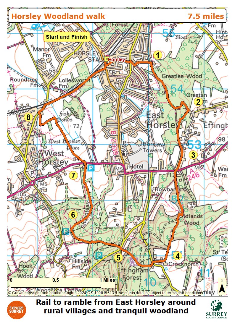
Map
The map shows the walk from East Horsley station through residential roads and footpaths until a track marked as Old London Road. It then goes into Great Ridings Wood and uphill to a vehicle track called Orestan Lane, further on through woodland and near the entrance to Horsley Park to reach Crocknorth Farm. The route passes near to several old bridges around the Sheepleas site at Green Dene and then on towards St Mary's church and car park. From here the route goes near West Horsley Place and joins The Street and on near Lollesworth Wood, residential streets and finishes back at the station where you started. Select the map of the route below to open a more detailed version in a new window that can be printed if necessary, using your browser print tool. Alternatively you can save the image to your mobile device for reference on your walk.