About the walk
A 6 mile long circular walk with gentle climbs from Friday Street near Dorking, with great views of the North Downs as you walk along rivers, hammer ponds from the historic iron industry, mills, farms and churches.

Route details
- Start and end address: Friday Street free car park
- Car park postcode: RH5 6JR
- Difficulty: challenging terrain
- Distance: 6 miles, 10 kilometres
- Type of walk: circular
- Approximate time: 3 hours
- Accessibility: gentle climbs and descents, several kissing gates and four stiles
- Facilities: There are pubs located around the route
- Ordnance Survey Map: Explorer 146 Dorking, Box Hill and Reigate
Getting there
By car: Friday Street is a tiny hamlet located just south of Wotton and about 4 miles south-west of Dorking. The walk starts and finishes at the free Friday Street car park, a woodland car park with a 2 metre height restriction barrier.
By bus: Bus route 22 serves Friday Street. From here it is half a mile's walk on a quiet single track road to reach Friday Street carpark. Take a look at Surrey bus timetables for details of public transport.
Points of Interest
The mill pond was created by damming a branch of the Tillingbourne river to give a head of water from which to drive a mill. There was a corn mill here in the early 1600s, but it is thought this pond may have been constructed to power a hammer for working iron.
Wotton House is the former seat of the Evelyn family including George Evelyn, one of the most successful pioneers of gunpowder in England. Later, John Evelyn a landscape designer, created a beautiful Italian garden here. Today the gardens are listed and the house is run as a hotel and conference centre.
Paddington Mill - A hammer mill was built here in Elizabethan times and in use for more than 200 years, working iron sows from furnaces as far away as Sussex. Wrought iron was produced ready for the blacksmith. The hammer mill gave Abinger Hammer its name.
Walk directions
This walk follows public footpaths and bridleways which cross private and public land. If you come across a problem on a public right of way, please notify us on our online fault reporting form.
For any feedback on this walk email us: countryside.bookings@surreycc.gov.uk.
Stages from start point through to end of walk
Please follow the Countryside Code.
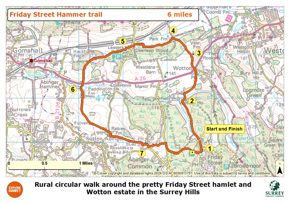
The numbers of each stage of the walk correspond with the points shown on the map.
- Start to mill pond
- Stage 1: Mill pond to Wotton House
- Stage 2: Wotton House to St Johns church
- Stage 3: St Johns church to Park Farm
- Stage 4: Park Farm to Wilberforce Monument
- Stage 5: Wilberforce Monument to Paddington mill
- Stage 6: Paddington mill to St James church
- Stage 7: St James church to end
Start to mill pond
Leave the car park with your back to the road and turn right joining the path which runs on the right-hand grass bank, with the road running on your left. This goes downhill and then down some steps to reach a junction with a gulley. Turn left for a few paces and then turn right along the road still walking downhill. After just 100 metres you will come to a junction alongside the mill pond within Friday Street.
Stage 1: Mill pond to Wotton House
At this junction by the pond turn left onto the tarmac access lane signed as a public footpath. Follow this as it leads you past a tiny post box set into the gatepost and then Pond Cottage, both on your right. Walk ahead and cross the ford or use the footbridge. Pass the next two properties, Pond Weed Place on your right and then Yew Tree Cottage on your left. You will come to a signed crossroads of footpaths with a wide gate ahead. Go straight on via the stile and continue along the fenced track with the Tillingbourne river running across to the left. Further along you will come to a signed point where the track divides in two. Take the left-hand path staying closest to the Tillingbourne across to the left. Later the track bends right away from the river. Simply follow the line of the left-hand fence as it then turns left, right and left again, taking you down a set of steps. At the end of this stretch of path cross the stile ahead into the corner of a field. Go straight ahead following the right-hand edge of the field. Across to the left you will have good views of the large red brick residence of Wotton House. At the top of the field cross the stile ahead to reach the access lane for Wotton House.
Stage 2: Wotton House to St John's church
Turn right along the access drive walking uphill and bending left. Within an avenue of trees and just before the drive begins to descend look out for a stile on the right. Cross this to enter a pasture and walk left heading for the metal gate just to the right of the single storey village hall. Pass through this metal kissing gate and walk straight ahead through the car park to reach the road by a T-junction with the Wotton Hatch pub on your left. Cross over the side road and follow the tarmac footway which leads you to the official crossing point for the A25. Cross via the central island turn left along the pavement for a few paces and then turn right into the small lane, signed to the Church of St John the Evangelist. A little way along ignore the footpath into the field on the right, just stay with the lane which leads you directly to St John's church.
Stage 3: St John's church to Park Farm
Take the wooden kissing gate to the left of the churchyard and follow the fenced path around the left-hand edge of the churchyard. Take time to enjoy the beautiful views ahead across to the hills of the North Downs. Beyond the church keep straight ahead on the obvious path leading you downhill between wire fences. The path leads you through a pretty section of woodland and on to a wooden kissing gate ahead. Pass through this and take the path which continues in the same direction across the centre of the crop field. The path leads you over the top of the hill and then down to a junction within the access lane for the property, Park Farm.
Stage 4: Park Farm to Wilberforce Monument
Turn left here on the signed bridleway following the line of the farm's garden fence on your right and then between several beautiful old barn buildings. Beyond the barns keep directly ahead on the narrow bridleway following the line of the woodland edge on your left. Simply stay with this bridleway for some distance, enjoying the tremendous views of the wooded hillside of the North Downs across to the right. You will then reach a junction with a country lane. Turn left for a few paces and then turn right onto a path which soon bends right to become a bridleway track. Follow this bridleway into the National Trust site of Abinger Roughs. Continue straight ahead on the main track and it will lead you to a stone cross, the Wilberforce monument, on your left.
Stage 5: Wilberforce Monument to Paddington mill
Beyond the monument simply keep straight ahead on the main bridleway track for some distance signed with a blue arrow and ignoring any side paths marked with yellow arrows. Further along the track leads you into a clearing with a couple of benches to pause and enjoy the surroundings.
Ignore the side bridleway turning away sharp right. Instead immediately beyond the clearing turn left down the side bridleway marked with a blue arrow leading to a wooden gate. Pass through this and keep ahead on the path through the hillside field. At the far side pass through the gate and follow the sunken path leading downhill under a tunnel of trees. This path leads directly out to the edge of the main A25 by a bus stop at the edge of Abinger Hammer. Cross over with care and take the tarmac access drive directly ahead. On the left you will see another large hammer pond and on the right you will see Paddington mill. On your right there are watercress beds taking advantage of the flowing clear waters of the Tillingbourne river.
Stage 6: Paddington mill to St James church
Continue along the access drive leading between the outbuildings of Paddington farm. At the T-junction with the old farmhouse ahead turn left and then immediately right to continue on the public bridleway. Follow this bridleway lined with hedgerows heading uphill to reach the first junction. Keep straight ahead staying with the main bridleway which gradually descends to reach a second junction at the edge of a large crop field. Leave the bridleway at this point turning left through the tree line and taking the obvious path which leads you across the crop field.
At the far corner of the field keep to the right of the double gates and this short section of path leads you out to the road opposite Raikes Farm. Turn right for about 10 paces and then turn left through the kissing gate to enter the farmyard. Within the farm buildings turn right to join the track which leads you past Raikes Farmhouse on your right. At the crossroads keep left following the line of the tall holly hedge on your left. Keep straight ahead at the next crossroads with magnificent views to the left of the North Downs. Further along pass through a kissing gate and follow the path leading past a property on your right and then later bends left to enter the churchyard of St James' church.
Stage 7: St James church to end
Keep straight ahead on the gravel path through the churchyard passing the church on your left. Go ahead through the roofed wooden gate and walk ahead passing the stocks on your left, to reach the road with the Abinger Hatch freehouse directly ahead. Turn right along the village road and then take the first road on the left immediately before the entrance gates for Mark Ash. Follow this small lane, Donkey Lane downhill to reach the entrance gates for Glebe House at the bottom. Stay with the lane walking uphill and over the top of the hill to reach a T-junction with Hollow Lane. Turn right along the edge of Hollow Lane for about 130 metres and then turn left onto the signed woodland bridleway. Follow this path all the way out to the junction with a quiet lane. Turn left along the lane soon joining the path along the right-hand embankment. Soon the lane will lead you to the car park on the right where the walk ends.
Map
The map shows the route from the car park to the mill pond in Friday Street and then into the Wotton Estate and house. It then crosses the A25 to the church and into woodland, beyond along the base of the North Downs and then re-crosses the A25 near Abinger Hammer village. It then goes past two farms to reach Abinger common and the church, beyond this uphill to Hollow Lane and back to the car park. Select the map of the route below to open a more detailed version in a new window that can be printed if necessary, using your browser print tool. Alternatively you can save the image to your mobile device for reference on your walk.