About the walk
An easy access circular walk to the north of Leatherhead across commons and a National Nature Reserve. The majority of the walk is in woodland but there are contrasting open areas too.

Route details
- Start and end address: Near to Tesco's supermarket, Leatherhead
- Car park postcode: KT22 0EF
- Difficulty: fairly easy
- Distance: 3 miles, 4.8 kilometres
- Type of walk: Circular
- Approximate time: 2 hours
- Accessibility: reasonably level surfaces and no stiles. Some busy roads to cross with care and the route crosses Leatherhead golf course.
- Facilities: refreshment options in Leatherhead. Toilets available in Tesco and B&Q.
- Ordnance Survey Map: Explorer 146 Dorking, Box Hill and Reigate
Getting there
By car: there is a car park at Tesco supermarket but parking is limited to two hours maximum for shoppers. On street parking can be found in Old Kingston Road where the B&Q store is located. Please do not park in or near farm or field entrances.
By bus: There are a number of bus routes that serve Leatherhead. Take a look at Surrey bus timetables for details of local routes.
By train: the nearest station is at Ashtead. From the station there is an attractive walk across Ashtead Common, along the public footpath to the left of the open grass area by the station and then left along a second public footpath to join the walk where it crosses the common. Look for the distinctive signposts with a green arrow marked LCW.
Points of Interest
This walk has been specially devised and signposted by the Lower Mole Partnership and Mole Valley District Council to provide an easy-to-navigate route into the countryside. This walk is signposted with a series of timber signposts with a distinctive green arrow and the acronym for Leatherhead Common Walk (LCW).
Teazle Wood is a 50 acre ecological Site of Conservation Importance that acts as a 'Living Landscape' corridor between Bookham and Ashtead commons. It was bought to save it from development by the Friends of Teazle Wood in 2012. Find out more on the Teazle Wood Trust website.
Ashtead Common National Nature Reserve (NNR) is one of four NNRs in Surrey designated by Natural England, it is owned and managed by the City of London Corporation who preserve the many ancient oaks thought to be around 1,000 years old. You will see many fine examples of ancient woodland and the habitat it supports such as birds, butterflies, mosses and lichens. This walk takes you around the south-western tip of this 200 hectare open space.
Walk directions
This walk follows public footpaths and bridleways which cross private and public land. If you come across a problem on a public right of way, please notify us on our online fault reporting form.
For any feedback on this walk email us: countryside.bookings@surreycc.gov.uk.
Stages from start point through to end of walk
Please follow the Countryside Code.
The numbers of each stage of the walk correspond with the points shown on the map.
- Stage 1: Start to Oaklawn Road
- Stage 2: Oaklawn to Oxshott Road
- Stage 3: Oxshott Road to Kingston Road
- Stage 4: Kingston Road to Ashtead Common
- Stage 5: Ashtead Common perimeter to end of walk
Start to Oaklawn Road
Take the footpath along the left edge of the road leading into Tesco's supermarket. Tesco's petrol station is ahead of you on your right and the Rye Brook on your left. Keep following this footpath into the woods ahead. At the timber footbridge turn right to follow the path along the edge of Teazle Wood which has a great variety of native trees, such as oak, ash, hawthorn, hazel and others. Further along the path you will pass Rowhurst Forge, the home of the Fire and Iron Gallery. Just visible beyond the forge is a mid-fifteenth century building, thought to have been used as a hunting lodge for Hampton Court Palace. The path winds its way between mature oak trees before reaching the M25. Here it turns left to follow the top of the motorway cutting. Follow the path beside the motorway to Oaklawn Road.
Stage 2: Oaklawn to Oxshott Road
On reaching Oaklawn Road cross over the road to the pavement on the other side and turn right to cross the bridge over the motorway. At the end of the bridge continue along the pavement past the first entrance to Combat Stress. At the second entrance cross back over the road and go down the footpath into the woods opposite. Continue along this path for about 150 metres before crossing a bridge over a small stream and bearing left. Carry on to a footpath sign and turn left near some mobile phone masts to join a straight path to Oxshott Road, the A244.
Stage 3: Oxshott Road to Kingston Road
At Oxshott Road you will reach a gate, pass by this to reach the road and turn right to walk a few metres before crossing the road. Take the tarmac road past a stone pillar into Pachesham Park. Follow the road straight ahead across a golf course fairway and then pass some houses on your right. The road then becomes a narrow track and crosses another fairway. Keep straight ahead through a break in a belt of trees and then continue on in the same direction across a practice area to a woodland belt parallel to the A243 Kingston Road. Follow a narrow path a short distance through the woodland to where the path emerges onto Kingston Road. Great care is needed here on this fast busy road.
Stage 4: Kingston Road to Ashtead Common
Cross the road to the footpath and cycle path opposite and turn left along Kingston Road for 200 metres until you reach a gate and a path leading onto the City of London-owned Ashtead Common National Nature Reserve. Follow the signposts straight on through the woodland for about 600 metres. When the route turns sharp right near the edge of the common follow another signposted route along a winding path for about 450 metres.
Stage 5: Ashtead Common perimeter to end of walk
At the perimeter of Ashtead Common you will emerge from woodland with a view to the south on your left-hand side. Cross over the wide path here into more woodland ahead for about 350 metres. When you emerge from this section of woodland keep to the footpath straight ahead and after a very short distance bear left to a tarmac path where you turn right to an underpass under a large roundabout. Follow the path through the underpass and then over the footbridge across the M25. Continue straight ahead down the hill and past the B&Q store until you come to a small roundabout. The Tesco store that was the starting point for the walk is on your right.
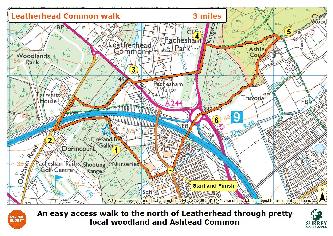
Map
The map shows the route from its start in Leatherhead Tesco's store, through Teazle Wood and along the M25 to reach Oaklawn Road and the motorway crossing point. It then goes across the southern tip of Leatherhead common into Pachesham Park residential area. Cross the A243 into the western side of Ashtead common and around a small section of the common until the underpass back under the M25 and the start and finish of the route. Select the map of the route below to open a more detailed version in a new window that can be printed if necessary, using your browser print tool. Alternatively you can save the image to your mobile device for reference on your walk.