About the walk
A flat circular walk from Ripley village green around Papercourt lake, open fields and a short stretch of the River Wey Navigations.

Route details
- Start and end address: free car parks on Ripley Green
- Car park postcode: GU23 6AN
- Difficulty: easy terrain
- Distance: 4.5 miles, 7.5 kilometres
- Type of walk: circular
- Approximate time: 1.5 hours
- Accessibility: flat unmade pathways that may be muddy, some footbridges, kissing gates and stiles
- Facilities: public toilets in the car park at the start of the walk and plenty of refreshment options in Ripley village.
- Ordnance Survey Map: Explorer 145 Guildford and Farnham
Getting there
By car: the walk starts and finishes at Ripley Green free car park off the High Street
By bus: bus routes 462, 463 and 715 serve Ripley village. Take a look at Surrey bus timetables for more detail.
Points of Interest
Papercourt lake is a popular spot for rowing, fishing and dinghy sailing with plenty of wildlife to look out for and a well-maintained path around its perimeter. The 45 acre lake is designated a Site of Special Scientific Interest (SSSI), a formal designation of conservation monitored by Natural England.
The River Wey was one of the first British rivers to be made navigable opening to barge traffic in 1653. The original part of the River Wey Navigations runs for over 15 miles from Guildford to the Thames at Weybridge with The National Trust being given the Navigations to look after in 1964. Papercourt lock was built in the 1780s and is one of the prettiest and most rural locks in the area.
Walk directions
This walk follows public footpaths and bridleways which cross private and public land. If you come across a problem on a public right of way, please notify us on our online fault reporting form.
For any feedback on this walk email us: countryside.bookings@surreycc.gov.uk.
Stages from start point through to end of walk
Please follow the Countryside Code.
The numbers of each stage of the walk correspond with the points shown on the map.
- Start to Papercourt lake north
- Stage 1: Papercourt lake north to Polesden Lane
- Stage 2: Polesden Lane to Tannery Lane
- Stage 3: Tannery Lane to Papercourt lock
- Stage 4: Papercourt lock to Papercourt lake west
- Stage 5: Papercourt lake west to end
Start to Papercourt lake north
Standing in Ripley Green car park with the toilets to your left, walk ahead to reach the access lane with the High Street junction across to your left. Cross over the access lane and take the vehicle track ahead. Keep right where the track splits in two, passing a row of houses on your left and a section of Ripley Green on your right. When the vehicle track ends, simply continue ahead along the grass path staying close to the line of houses on the left. You will come to a junction with the B367 Newark Lane with the beautiful red brick arch lodge gates of Dunsborough Park on your right.
Turn right along the pavement and continue out of the village crossing a stream and passing the entrance for Homewood Farm on your right. Follow the boundary wall for this farm on your right and where a grass verge begins alongside the pavement, turn left across the road to take a narrow dirt path on the opposite side towards the lake. Ignore the stile on your left and follow the short path leading you to the northern end of Papercourt lake.
Stage 1: Papercourt lake north to Polesden Lane
Turn left along the waterside path following the path in a clockwise direction with the lake on your right. The lake edge is lined with beautiful coppiced trees and soon a pretty stream will begin on your left. Further along you will come to a point where the path splits. Take the right-hand path leading you onto the grass embankment directly alongside the water, this can be muddy. Follow this embankment ahead, there are some benches along this stretch should you wish to pause and enjoy the views. Towards the end of the lake the path continues left following the fence line of the sailing club's boatyard on your right. As you draw level with the back of the boatyard turn left and follow the grass track through the trees to reach a grass clearing. Turn right and walk straight ahead on this path until you reach a T-junction with a fence ahead. Turn right and follow this path which leads you through a gap in a wooden fence and on to reach a stile. Cross the stile and you will arrive on Polesden Lane.
Stage 2: Polesden Lane to Tannery Lane
Cross over the road, turn right along the pavement and then cross over the side road, Danesfield Road. Immediately afterwards turn left through the wide wooden gate passing under a height barrier. Follow the line of the fence on your left to join a narrow path which leads you past a section of allotments and then a large crop field both on your right. When the wooden fencing on the left ends stay with the path along the left-hand edge of the field, soon leading you over a footbridge. The path bends left to reach a junction with a signpost alongside a second footbridge. Turn right here staying with the left-hand edge of the large crop field. At the end of the field you will come to a T-junction with a path within an avenue of trees.
Turn left and follow the path right over a footbridge and then stay with the fenced path winding round the field edge and crossing two further bridges. As you approach a collection of houses stay with the field edge path which bends right. A section of concrete path leads you past some old corrugated iron barns on your left, just keep straight ahead. As you approach the road turn right to follow the path with the roadside hedge running on your left. After passing a single garage building turn left through the kissing gate to reach Tannery Lane.
Stage 3: Tannery Lane to Papercourt lock
Turn right to join the footpath which runs along the right-hand edge of the lane. Further along this path leads you through a beautiful hedgerow tunnel. You will come out to the edge of Send Business Park. Stay with the signed footpath keeping right and passing the business park buildings including Tannery House across to your left. Just beyond Tannery House keep left to leave the public footpath to reach the junction with the Park's access road. Turn left along this and then walk immediately to the right of Tannery House to reach the River Wey Navigation canal. Cross the canal bridge ahead and turn right to join the towpath. Follow the towpath with the canal running on your right. Down to your left is another water channel, Broadmead Cut and beyond this, meandering out of sight through the marshland, is the original course of the River Wey. Continue along this pretty towpath as far as the first lock, Papercourt Lock.
Stage 4: Papercourt lock to Papercourt lake west
Continue past the lock keeper's cottage on your left and follow the main path as it bends right over the canal bridge. At the far side, follow the vehicle track which bends right leading you to a stile alongside a wide gate. Please note this field is likely to be holding cattle. Cross the stile and follow the obvious vehicle track bending left and then right to reach the wide metal gate at the far side. Cross the stile to the left of the gate and walk ahead along the vehicle access lane. As you approach the farm buildings pass through the single black self-closing gate and walk directly ahead into the yard of Papercourt Farm. Keep right to reach the junction with Papercourt Lane. Turn left along the lane passing the farm buildings on the left and just before a wooden fence begins on the right, turn right ducking under a height barrier to join the signed public footpath.
Follow the narrow path and further along it merges with a vehicle track. At the end of this track pass alongside a disused stile to reach a junction with a lane. Cross over passing alongside another disused stile directly ahead and you will come to a T-junction with a path on the western edge of Papercourt lake.
Stage 5: Papercourt lake west to end
Turn left and follow the path into the stone parking area for the Angling Club and Distillers of Surrey premises. Pass to the right of the Distillers wooden building to join the path alongside the lake. Follow this path with the lake on your right passing a number of properties on your left. Stay with the path as it bends right leading you across the northern edge of the lake passing a large pylon on your right. About 100 metres later you will come to a small clearing with an Angling Club sign, this is the same point at which you joined the lake path at walk stage 1 above. Turn left through the gap in the hedgerow and follow the narrow path back to the road. Cross over and turn right along the pavement heading back towards Ripley village. For this return part of the walk, continue past the Dunsborough Park Lodge on your left, but do not turn left into the Green, instead keep straight ahead on the pavement and you will come to the T-junction with Ripley High Street. Turn left along the High Street and follow this until you reach the Ripley village sign on a small triangular green. Just before this sign turn left into the access road for Ripley Green. A few metres along you will come to the car park on the right where the walk ends.
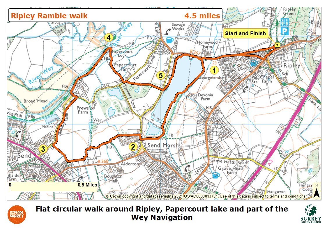
Map
The map shows the walk from Ripley village towards and around Papercourt lake. It then goes through fields to Tannery Lane, along the Wey Navigation as far as Papercourt lock and across the farmland of Papercourt farm. It crosses Polesden lane to return to the western side of Papercourt lake and along the riverside path to rejoin Newark Lane towards Ripley village and end of the walk. Select the map of the route below to open a more detailed version in a new window that can be printed if necessary, using your browser print tool. Alternatively you can save the image to your mobile device for reference on your walk.