About the walk
A relatively easy flat circular walk from Weybridge Station. The route passes through part of Weybridge town and along the towpath of the Wey Navigation between Weybridge and New Haw village.

Route details
- Start and end address: Weybridge railway station
- Car park postcode: KT13 8UD
- Difficulty: moderate terrain
- Distance: 4.5 miles, 7 kilometres
- Type of walk: circular
- Approximate time: 2 to 2.5 hours
- Accessibility: flat, no stiles, some steps
- Facilities: refreshments and toilets at Weybridge station plus many other options en route
- Ordnance Survey Map: Explorer 160 Windsor, Weybridge and Bracknell
Getting there
By train: Weybridge is on the main London Waterloo to Portsmouth railway line run by South Western railway.
By bus: Falcon route 436, 514 and 515 serve Weybridge station, find out more from Surrey Bus timetables.
By car: the station has a small car park, charges apply at all times. The Heath, South pay and display car park is next to the station on the opposite side of the railway line, postcode is KT12 0UN. The car park entrance is opposite Cobbett Hill on Brooklands Road (B374).
Points of Interest
The Wey Navigation is more than 15 miles in length and runs from the River Thames at Weybridge to Guildford. It was completed in 1653, making it one of the earliest navigations and the first to use long stretches of separate canal to transport bulky goods from London to Guildford. There are nine miles of 'new cut' as it was called at the time. The canal and meandering river separate at the former wharf at Wey Bridge and are not reunited until Walsham Lock near Pyrford.
Coxes Lock is one of 12 locks on the Wey Navigation. Coxes Mill was built in the early 1780s by Alexander Raby and used as a corn mill from 1829 until it was closed in 1983. Barges regularly delivered grain to the mill until 1969 when grain terminals from London Docks to Tilbury were removed, ending the trade. An attempt was made to revive this trade in the late 1970s. After a long family association, the last proprietor Harry Stevens transferred the canal to the National Trust (NT) and it is now a popular recreational waterway. Find out more at National Trust's River Wey and Godalming Navigations.
Walk directions
This walk follows public footpaths and bridleways which cross private and public land. If you come across a problem on a public right of way, please notify us on our online fault reporting form.
For any feedback on this walk email us: countryside.bookings@surreycc.gov.uk.
Stages from start point to end of walk
Please follow the Countryside Code.
The numbers of each stage of the walk correspond with the points shown on the map.
- Start to Fir Grange Avenue
- Stage 1: Fir Grange Avenue to St. James' Church
- Stage 2: St James' Church to Old Wey bridge
- Stage 3: Old Wey bridge to Black Boy bridge
- Stage 4: Black Boy bridge to Coxes Mill and Lock
- Stage 5: Coxes Mill and Lock to New Haw
- Stage 6: New Haw to rail crossing
- Stage 7: Rail crossing to Seven Arches bridge
- Stage 8: Seven Arches bridge to end
Start to Fir Grange Avenue
From the station ticket office or The Heath (South) car park, walk back to Brooklands Road. Cross Brooklands Road at the triangular island by the roundabout and follow the footpath straight ahead. This will take you alongside the railway in a deep cutting on the right. Eventually the path bends to the left alongside an old brick wall and then bends right to pass through a gap in the wall. Follow the path until it reaches the road.
Stage 1: Fir Grange Avenue to St James' Church
Keep left into Fir Grange Avenue, a private gravel drive with vehicle barrier and then continue straight ahead into Windsor Walk. At the T-junction turn left into Pine Grove to meet the next T-junction with Hanger Hill. Cross over and then turn right to follow the pavement downhill. About 100 metres before the traffic lights turn left down a wide tarmac footpath. Follow this long straight path, go straight ahead at a crossroads of paths and pass the lido and children's play area on the right. Follow the path as it bends right then left with allotments on the left and the car park for Weybridge Library on your right. The path comes out at St James' Church.
Stage 2: St James' Church to Old Wey bridge
Continue with St James' Church on your right for a short distance until you reach the T-junction with Church Street, cross over here and turn left to follow the pavement past a number of small shops. Take the next road on the right which is Bridge Road. Continue to the end of the road and cross over the river on Old Wey Bridge, a Grade 2 listed bridge.
Stage 3: Old Wey bridge to Black Boy bridge
Continue past Weystone Road on your right, then cross the road and turn right to join the narrow canal towpath between the road and canal. Follow the narrow towpath with the canal on your left until you reach the next bridge, Black Boy Bridge.
Stage 4: Black Boy bridge to Coxes Mill and Lock
At Black Boy Bridge you will need to cross the bridge to follow the towpath on the opposite side. As you cross the bridge keep close to the right-hand barrier to follow the fenced footpath down to the towpath. The canal will now be on your right. Continue along the towpath for 650 metres passing under a railway bridge and you will arrive at Coxes Mill and Lock.
Stage 5: Coxes Mill and Lock to New Haw
Coxes Lock is one of twelve locks on the Wey Navigation. Continue along the towpath for just under a mile until you reach the road bridge at New Haw.
Stage 6: New Haw to rail crossing
At the road bridge at New Haw turn left and follow the pavement as the road bends to the right. Immediately before a row of houses turn left down a narrow footpath with trees either side and marked with a wooden signpost. Follow the path as it bends to the right and then turn left to merge with a wider unmade road. As the unmade road bends to the left and you reach another wooden footpath signpost, go straight ahead up the narrow tarmac footpath with hedgerows on each side. Continue along this footpath until you reach the gate to the railway crossing.
Stage 7: Rail crossing to Seven Arches bridge
Go through the gate, up the steps and cross the railway with care and then go down the steps and through the gate at the other side. Continue straight ahead and enjoy the views of the lake to the left which was formed from a former section of the meandering River Wey. Continue with the railway embankment on your right until you reach a footbridge over the River Wey alongside Seven Arches Bridge.
Stage 8: Seven Arches bridge to end
Cross the small footbridge over the River Wey. Continue ahead and the path will merge with a small road, becoming a pavement and then reaching a T-junction. Turn right to cross the bridge over the railway and then take the road on the left, Lonsdale Road. Go to the end of Lonsdale Road and then take the footpath through a staggered barrier to the left of the gated estate called Hadley Place. Follow this footpath until it arrives back at The Heath (South) car park where the walk started, with Weybridge rail station on your left.
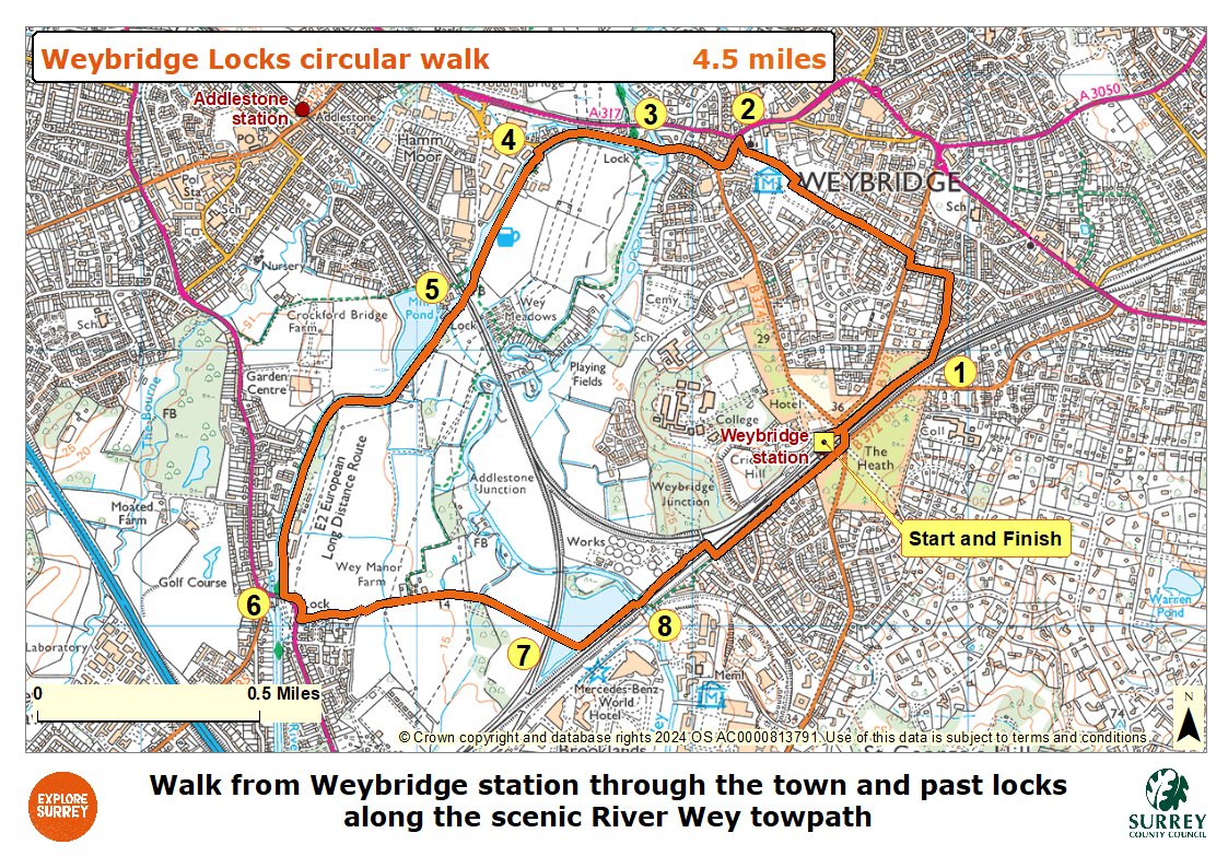
Map
The map shows the walk from the start to Fir Grange Avenue and on to St James' church. From the church it goes to Old Wey bridge to Black Boy bridge and on to Coxes mill and lock to New Haw village. From New Haw to rail crossing on to Seven Arches bridge to the end of the walk at Weybridge railway station. Select the map of the route below to open a more detailed version in a new window that can be printed if necessary, using your browser print tool. Alternatively you can save the image to your mobile device for reference on your walk.