About the walk
A 5 mile rural circular walk from Sidney Wood near Alfold not far from the West Sussex border. You will be exploring woodlands, parkland and a stretch of the old Wey and Arun Canal towpath.
 Route details
- Start and end address: Forestry Commission free car park in Sidney Wood, accessed from Dunsfold Road
- Car park postcode: GU6 8HU
- Difficulty: moderate terrain
- Distance: 5 miles (8 kilometres)
- Type of walk: circular
- Approximate time: 2.5 hours
- Accessibility: no stiles or kissing gates (allows people to pass through but not livestock), however there are some uneven tracks
- Facilities: no refreshments directly on the walk, picnic area at start. Pubs in nearby Alfold and Loxwood
- Ordnance Survey Map: Explorer 134 Crawley and Horsham
Getting there
By car: Access the car park from Dunsfold Road between Alfold Crossways and Dunsfold. There is no sign for this woodland car park from the road, but the woodland access drive is shared with two properties, Cobdens Farm and Sedgehurst. As you enter the woodland keep left at the first two splits in the road, pass under the 2 metre height restriction barrier and you will see the Sidney Wood Forestry Commission car park on your right.
By bus: Compass bus route 42 stops at Alfold Crossways. Take a look at Surrey bus timetables for further details.
Points of Interest
Fir Tree Copse nature reserve at the start of the route, was once part of the ancient Chiddingfold Forest and comprises hazel, oak and ash with an annual springtime carpet of bluebells.
This walk goes along the towpath of the old Wey and Arun Canal, some of it on the Wey South Path. The canal was dug during the Napoleonic Wars in the early 1800s and is now reclaimed by nature with some stretches undergoing restoration.
Along the towpath you will discover the restored Gennets bridge lock. This lock is one of the more recent restoration success stories of the Wey and Arun Canal Trust who aim to restore the entire 23 miles of the canal.
Walk directions
This walk follows public footpaths and bridleways which cross private and public land. If you come across a problem on a public right of way, please notify us on our online fault reporting form.
For any feedback on this walk email us: countryside.bookings@surreycc.gov.uk.
Stages from start point through to end of walk.
Please follow the Countryside Code.
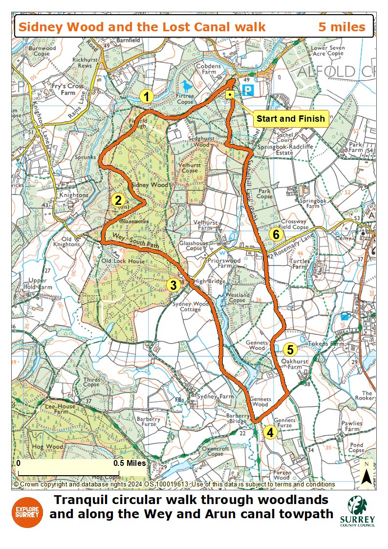
The numbers of each stage of the walk correspond with the numbers shown on the map.
- Start to the canal towpath
- Stage 1: Canal towpath of lock flight
- Stage 2: Lock flight to High bridge
- Stage 3: High bridge to Gennets bridge lock
- Stage 4: Gennets Bridge lock to Oakhurst Cottage
- Stage 5: Oakhurst Cottage to Rosemary Lane
- Stage 6: Rosemary Lane to end
Start to canal towpath
Leave the car park via the vehicle entrance and turn left to pass under the height restriction barrier. After about 120 metres turn sharp left onto the first left-hand driveway, marked with a Sedgehurst Private sign on your left, soon passing a blue arrow on a signpost on your right which marks this driveway as a public bridleway. Continue for about 500 metres to reach a tall signpost on your right. Turn right here leaving the tarmac drive to join the unmade bridleway path, passing between wooden bollards and leading you into the woodland. Follow the bridleway ahead passing the nature reserve called Fir Tree Copse on your right.
Ignore the path signed right into this nature reserve and you will come to a point where the bridleway splits in two marked with two blue arrows. Take the right-hand path and this leads you to an old metal gate ahead. Pass alongside this gate and you will immediately cross over the course of the derelict Wey and Arun Canal. Immediately after this turn left onto the public footpath, part of the Wey South Path that follows the old towpath with the old canal running on your left.
Stage 1: Canal towpath to lock flight
Walk ahead along the old towpath. The old canal on your left may appear as a water channel or just a muddy trench depending on the time of year and recent weather. Stay on the towpath ignoring two footpaths signed off to the right and passing the concrete milestone marked 'Arun 13 - Wey 10'. The canal now bends left then sharp right. On this next straight stretch of canal you will pass a wider basin area and then a section of path with steeper tree-lined banks. This marks the point that once held a flight of six locks.
Stage 2: Lock flight to High bridge
Continue along the towpath until you emerge to a junction with a tarmac access track with the white property called Knightons Court ahead. Turn left to join this tarmac access track leading you through the woodland. You will come to a vehicle barrier ahead alongside a Sidney Wood sign. Pass alongside the barrier and keep ahead on the stone path leading you through the woodland. At the first woodland crossroads keep straight ahead. As you reach the next vehicle barrier ahead pass alongside this and follow the fenced track leading you past the white property at High Bridge on your right.
Stage 3: High bridge to Gennets bridge lock
Immediately after the property you will reach a T-junction with a tarmac access lane. Turn right passing the house on your right and then turn immediately left to join the signed public bridleway, you will have the canal channel running on your left once again. Follow this pretty stretch of old towpath ahead. Further along you will be able to see the beautiful fishing lakes of Upper Oakhurst on the far bank to your left. Ignore the three side path options, a canal footbridge on your left, a stile on your right and a second footbridge on your left. Just after passing the concrete milestone marked 'Arun 11.5 - Wey 11.5', you will find yourself at the restored Gennets bridge lock.
Stage 4: Gennets bridge lock to Oakhurst Cottage
Immediately after passing the lock turn left to cross the canal bridge signed as part of the Sussex Border Path. You have now crossed into the county of West Sussex for this most southerly portion of the walk. After crossing the canal keep ahead on the bridleway stone track leading you through the woodland. After about 400 metres you will reach a signpost on your left marking a crossroads of bridleway paths. Turn left here on the signed bridleway to join the unmade track between hedgerows. The track leads you past a large cottage on your left Oakhurst Cottage, to reach a staggered crossroads of tracks.
Stage 5: Oakhurst Cottage to Rosemary Lane
Walk straight ahead at this crossroads and follow the vehicle track leading you away from the cottage and through the open grassland. Keep ahead on this main track passing a pretty pond on your right and then bending right then left. At the next signpost ignore the footpaths signed to the side, instead walk straight ahead on the main bridleway track. Pass through the bridle gate ahead the wider farm gate alongside may be open too to reach a split in the track. Take the right-hand path leading you through the trees to reach an access drive lined with wooden posts. Follow the bridleway ahead with the wooden posts running on your right. You will come out at a junction with Rosemary Lane.
Stage 6: Rosemary Lane to end
Cross over the lane and take the signed public bridleway directly ahead leading you past the entrance for Rosemary Cottage on your left. Stay ahead on the woodland track bridleway which is an old thoroughfare known as Sachelhill Lane. After about 800 metres look out for a signpost on your right, marking a side path on your right. Do not take this, instead walk straight ahead for a further 20 metres and then turn left onto the path into Sidney Wood, marked with a 'Riding By Permit Only' sign. Pass this sign on your right and ignore the small side path into the trees on your right, instead keep straight ahead on the main forest stone path. You will join a junction with a wider stone track leading ahead and right. Turn right to join the stone track and follow this for about 400 metres to reach a vehicle barrier. Here you will find the car park on your left where the walk began and ends.
Map
The map shows the walk from the start in Surrey to the canal towpath, on to the old lock flight, then to High Bridge, Sidney Wood and Gennets Bridge. After this the walk goes into West Sussex taking the Sussex Border Path, through woodland and back to the start via Sachelhill Lane bridleways. Select the map of the route below to open a more detailed version in a new window that can be printed if necessary, using your browser print tool. Alternatively you can save the image to your mobile device for reference on your walk.