About the walk
A circular 5 mile walk exploring the suburbs around the village of Ash and linking the history of transport in the Blackwater Valley that will take you along the old railway path, the Blackwater Valley riverside path and the Basingstoke Canal towpath.
 Route details
- Start and end address: Coronation Gardens car park on Ash Hill Road
- Car park postcode: GU12 5DN
- Difficulty: easy terrain
- Distance: 5.5 miles, 8 kilometres
- Type of walk: circular
- Approximate time: 2.5 hours
- Accessibility: steps, some staggered barriers, part of walk along a country lane without pavements and you will also need to cross the A323 dual carriageway at a designated but unsignalled crossing point
- Facilities: options for refreshments on the way round at points 1, 3 and in Ash village
- Ordnance Survey Map: Explorer 145 Guildford and Farnham
Getting there
By car: The walk starts and finishes from the Coronation Gardens car park on Ash Hill Road in Ash opposite Victoria Hall (with its distinctive clock tower). The car park is free and has a 2m height restriction barrier.
By bus: Stagecoach bus routes 3 and 20 serve the area. Take a look at Surrey bus timetables for details of public transport.
By rail: Ash rail station is just a short walk away. From Ash railway station, turn left to follow Church Road to the roundabout, turn left into Ash Hill Road and you will reach Coronation Gardens on your right.
Points of Interest
The old railway path follows the route of the London and South Western railway line that was finally closed in 1960.
The Blackwater Valley 23 mile riverside path links nature reserves and country parks along its length.
The Basingstoke Canal runs for 32 miles from New Haw in Surrey as far as the collapsed tunnel at Odiham in Hampshire. It is fully navigable with a well-maintained towpath and a haven for wildlife.
Walk directions
This walk follows public footpaths and bridleways which cross private and public land. If you come across a problem on a public right of way, please notify us on our online fault reporting form.
For any feedback on this walk email us: countryside.bookings@surreycc.gov.uk.
Stages from start point through to end of walk
Please follow the Countryside Code.
Each stage of the walk corresponds with the numbers shown on the map.
- Start point to Guildford Road
- Stage 1: Guildford Road to old railway path
- Stage 2: Old railway path to Blackwater Valley path
- Stage 3: Blackwater Valley path to Basingstoke Canal
- Stage 4: Basingstoke Canal to end
Start to Guildford Road
Stand in the car park, facing the road with Victoria Hall opposite. Turn left out of the car park to join the unmade path beside a vehicle barrier which leads you through the trees with the road running across to your right. Continue directly ahead until you reach the junction with a side road. Keep directly ahead along this passing the red brick youth and community centre on your left. Immediately afterwards you will come to a point where the track splits in two. Take the left-hand path passing alongside a vehicle barrier to enter the Ministry of Defence (MoD) training area. For your safety please keep to the main tracks and follow any advice notices.
Stay with the wide stone track leading you gently uphill and continue just until you reach the first crossroads with another major vehicle track with a gnarled oak tree on your right. Turn right here and follow the vehicle track downhill. At a major junction of six paths keep straight ahead on the track ignoring two paths to the left and two to the right. Follow this continuing downhill. Go straight on at the next crossroads and you will come to a small car park. Keep ahead down the access lane to reach the junction with Guildford Road.
Stage 1: Guildford Road to old railway path
Cross over Guildford Road and over the stile ahead to enter the playing fields. (Note: If you need to avoid this stile, turn right along the pavement and then take the first side road on the left, Harpers Road. Follow this past the car park for the recreation ground and then pick up the directions from there.)
Cross the playing field diagonally heading towards the row of white houses at the far side. Leave the field by going over the little wooden footbridge alongside the vehicle barrier, turn right through the car park and you will arrive at Harpers Road. Turn left along Harpers Road and continue past a property on your left and then a series of properties on your right which sit behind a pretty stream. Continue ahead beyond these properties until you approach the road junction on the bend. Turn right to cross the railway bridge and 60 metres later ignore the signed byway on your left. Stay with the lane for about 300 metres then turn left into the small side road, Drovers Way. Follow this lane between properties and about 20 metres beyond the last house on the left, turn right down the shallow steps to reach a T-junction with the old railway path.
Stage 2: Old railway path to Blackwater Valley path
Turn right to join the old railway path and follow it for its full length. At the end of the railway path follow the main tarmac path as it bends right and then keep right on the path to reach a junction with a quiet lane. Turn left along this lane and follow it to the T-junction at the end. Cross over and turn left to reach a second T-junction. Turn right here and soon you are forced to swap to the left-hand pavement, passing The Cricketers pub on your left. Immediately after the pub turn left into the gravel access drive called The Moors. Follow this ahead ignoring the footpath into the bowling green on your right. Pass through the gap to join the tarmac path and follow it through the underpass beneath the dual carriageway. At the far side pass alongside the black vehicle barrier and immediately afterwards, turn right through the staggered barrier to join the Blackwater Valley path.
Stage 3: Blackwater Valley path to Basingstoke Canal
Follow this stone path winding ahead with the river Blackwater on your left and the dual carriageway running to your right. Further along you will come out to a junction with a side road. Turn left for a few paces to reach the T-junction with the A323 dual carriageway within an industrial area. Turn right crossing over the side road and 40 metres later just before the roundabout, you will come to the official but unsignalled pedestrian crossing point for the A323. Cross with extreme care. Keep ahead passing through the gap alongside the wide metal gate to re-join the Blackwater Valley path. Stay with the path as it follows the line of the river and industrial units on your left.
Stay with the tarmac riverside path for some distance. Along the way you will be forced left over a wooden footbridge to join the left-hand riverbank and soon afterwards, back right over another footbridge to continue on the right-hand riverbank once again. Eventually the path will lead you under a large bridge with blue railings and a curved base. This is the aqueduct which carries the Basingstoke Canal overhead. Pass under this follow the path left over a footbridge and up a long slope to reach the Basingstoke Canal.
Stage 4: Basingstoke Canal to end
Turn left along the towpath following it over the aqueduct. Continue on the towpath with the canal running on your right. Through the trees on the opposite bank you will see Willow Park Lake, and through the trees on your left are the lakes of Lakeside Park Nature Reserve. Stay with the canal towpath as it leads you under the rail bridge and continue to the next bridge. Pass under this and turn immediately left up the tarmac slope to reach the junction with Vale Road. Turn left over the bridge and you will come to the mini roundabout and across to the left there is a parade of shops. Go straight ahead at the mini roundabout and follow the pavement uphill passing Ash Centre on your left. Further along you will reach the car park where the walk ends on your left.
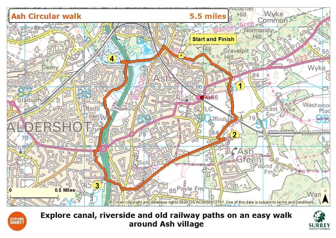
Map
The map shows the walk from Ash village around residential roads until you join the old railway path. It then joins the Blackwater Valley riverside path and then the Basingstoke Canal towpath until you arrive back in Ash village.
Select the map of the route below to open a larger version in a new window, that can be printed, if necessary, using your browser print tool with landscape selected. Alternatively, you can save the image to your mobile device, for reference on your walk.