About the walk
A 3 mile circular walk from The Bluebell pub in the village of Dockenfield, near Farnham, exploring the local village paths, woodlands and open fields along the way.

Route details
- Start and end address: The Bluebell Pub, Dockenfield
- Car park postcode: GU10 4EX
- Difficulty: challenging terrain with hills and descents
- Distance: 3 miles, 5 kilometres
- Type of walk: circular
- Approximate time: 1.5 hours
- Accessibility: several kissing gates (allows people to pass through but not livestock) and stiles
- Facilities: The Bluebell pub for refreshments and toilets at beginning and end of walk
- Ordnance Survey Map: Explorer 145 Guildford and Farnham
Getting there
Dockenfield lies at the western edge of Surrey, alongside the border with Hampshire and adjacent to Alice Holt Forest.
By car: The Bluebell pub has a car park, toilets and refreshments. Users please be aware this is a busy car park for visitors to the pub.
By bus: Surrey Connect on demand services are available in this area.
Points of Interest
Abbots Wood is a pretty woodland, with lovely displays of bluebells in the late spring. For many years hops were grown in this area and the hops were dried in local oast houses using charcoal produced from these areas of coppiced woodlands. You will pass a former oast house later on the walk.
At stage 4 of the walk, you may choose to take a short detour to visit some points of interest. Turn left along the grass verge and almost immediately you will see the Dockenfield village sign, an elaborate sculptural plaque. Notice the reference to Noel Coward's song, 'A Room with A View'. It is said that Coward wrote his famous play 'Hayfever' whilst staying with his mother who lived in Dockenfield. Continue a few paces ahead to the bus stop and if you look to your right you will see the roof of one of the old village oast houses, now converted to a private home.
Dockenfield Church was built in 1910 using local bargate stone, galletted with brick dressing. Galletting, the studding of mortar with ironstone, is a characteristic local style and is both decorative and practical. Note that the church has a bell mounted on the wall, rather than being within a tower or steeple.
Walk directions
This walk follows public footpaths and bridleways which cross private and public land. If you come across a problem on a public right of way, please notify us on our online fault reporting form.
For any feedback on this walk email us: countryside.bookings@surreycc.gov.uk.
Stages from start point through to end of walk
Please follow the Countryside Code.
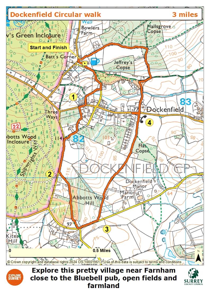
The numbers of each stage of the walk correspond with the points shown on the map.
- Start to Dockenfield Street
- Stage 1: Dockenfield Street to Abbots Wood
- Stage 2: Abbots Wood to pasture stile
- Stage 3: Pasture stile to Church of the Good Shepherd
- Stage 4: Church of the Good Shepherd to end
Start to Dockenfield Street
Leave the The Bluebell pub car park and turn left along the lane. Walk straight ahead as the lane narrows to become a tarmac track, passing a 'No Through Road' road sign on your left. About 60 metres later you will see a signpost on your right. Turn right here to join the signed public footpath leading downhill into woodland. At the bottom of the hill keep ahead onto the tarmac lane, passing a large brick property, Rose Cottage, on your right. Immediately after Rose Cottage stay with the main lane which turns right, continuing downhill. After just a short distance where the hedge on your right ends, turn right to join a stone track signed as a public footpath. Follow this path as its narrows to continue between trees and fences. At the T-junction in the path turn left and follow the narrow path uphill to reach a junction with the village road, Dockenfield Street.
Stage 1. Dockenfield Street to Abbots Wood
Turn right along the street. Immediately after the last house on the left turn left to join the signed public footpath. Follow this grass path leading you uphill between hedgerows then fences. Eventually you will pass an old concrete barrier to reach a T-junction with another path. Turn right along the path and as you arrive at a property's driveway, walk ahead along this to reach a junction with the road, High Thicket Road. Directly ahead of you is the start of Alice Holt Forest, a Forestry Commission woodland within Hampshire that was once part of the Royal hunting forest, Woolmer Forest. Turn left along the road and after 300 metres at the end of the second field on your left, turn left through a kissing gate. Follow the enclosed path with Abbots Wood on your right.
Stage 2. Abbots Wood to pasture stile
The path leads you through Abbots Wood, a pretty stretch of woodland. Pass through the metal kissing gate and continue straight ahead on the woodland path. At the far side of the woodland a metal kissing gate leads you into a grass field. Walk straight ahead downhill and exit via the stile to reach the road, Old Lane. Turn left along the lane and look out for the far-reaching views of the hills ahead. Continue for just 220 metres, the length of one field on your left to reach a stile alongside a metal gate on your left. Turn left across this stile to enter a pasture (may be holding livestock).
Stage 3. Pasture stile to Church of the Good Shepherd
Walk directly ahead along the left-hand edge of the pasture and pass through the wide gateway with a disused stile, to continue along the left-hand edge of a second section of pasture. In the field corner cross the stile and continue ahead on the enclosed grass track to reach a metal kissing gate. Take the kissing gate to enter a large hillside pasture (may be holding sheep) and walk straight ahead staying close to the hedgerow on your right. At the far side pass through the wide gateway and continue along the right-hand edge of this second sheep pasture. In the field corner follow the path through a ditch and over a stile to enter a section of woodland. Keep ahead on the pretty woodland path ignoring a footpath signed to the right as you walk along. At the end of the woodland you will come to a small playing field. Cross this diagonally left to reach a T-junction with the main road. Beyond the bus stop you will come to the Church of the Good Shepherd on your left.
Stage 4. Church of the Good Shepherd to end
You may wish to visit the church. If so retrace your steps back along the lane, passing the bus stop on your right and the oast house on your left. Just before you reach the road chicane turn left into the side lane, Bealeswood Lane. Follow this pretty lane down through the dip and starting to go uphill. Just after the lane bends left you will see a signpost on your right and at this point you have two choices.
For the shortest route back to The Bluebell pub simply stay with the lane as it bends left. This lane and then a bridleway track ahead will lead you directly back to the pub.
For the full route turn right on this bend signed as a public bridleway and follow the grass path past a house and hedge on your left. Immediately after the hedge turn left over a stile to enter a large grass field. With your back to the stile walk diagonally uphill to exit through another stile into woodland. Follow the woodland path leading you uphill.
At the top of the hill you will reach a junction with a vehicle track. Cross over and go straight ahead through the next short section of woodland, arriving at a path crossroads with a signpost. Turn left and follow the level path through this pretty stretch of woodland. Follow this path ahead to the far end of the wood ignoring a footpath signed to the right as you walk along. At the far end turn left across a stile and follow the enclosed path, with horse paddocks on your left and a property on your right. At the end of this path turn sharp right over a little wooden footbridge and then left to join a stone vehicle track. You will reach a junction with the road. Turn left and immediately left again and you will reach The Bluebell pub on your left where the walk ends.
Map
The map shows the walk from the Bluebell pub to Dockenfield Street, a short walk along the road and then into Abbots Wood. The route then goes through pastures until it reaches a playing field, a bus stop and the church nearby. From the church turn into another woodland that goes along the edges of Middle, Swan's and Falkner's Copses before reaching the pub and end of the walk. Select the map of the route below to open a more detailed version in a new window that can be printed if necessary, using your browser print tool. Alternatively you can save the image to your mobile device for reference on your walk.