About the walk
An easy access walk around Elstead Common through woodland, open areas of heathland and several ponds and streams. The common is a Ministry of Defence (MoD) training area so visitors are asked to comply with all instructions and byelaws on notice boards.

Route details
Important visitor information: Please be aware that Heathland is particularly at risk of wildfires. Never use a barbecue or throw away matches, cigarettes or glass bottles. Leave no trace of your visit.
- Start and end address: Royal Common parking area, B3001
- Car park postcode: GU8 6LA
- Difficulty: easy terrain
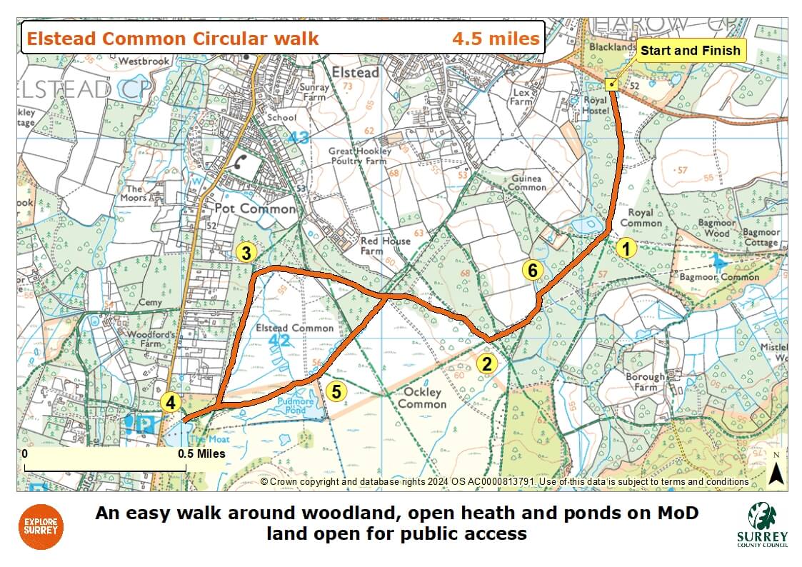
- Distance: 4.5 miles, 7 kilometres
- Type of walk: circular
- Approximate time: 2 hours
- Accessibility: all the paths are wide tracks and there are no stiles, gates or steps on the route
- Facilities: Three pubs and a shop in Elstead village
- Ordnance Survey Map: Explorer 145 Guildford and Farnham
Getting there
Elstead village is located on the B3001, about half way between Farnham and the A3 junction at Milford.
By car: Royal Common parking area on the B3001 is about one mile east of the village. It is a large stone parking lay-by with space for about 12 cars and has no height restriction barrier. The postcode will take you to the eastern end of Elstead village. From here, continue east on the B3001, keep right where the road splits signed A3 and you will shortly find the parking area on the right by a sign for a public bridleway.
By bus: Stagecoach bus route 46 serves Elstead village. Take a look at Surrey bus timetables for details of public transport.
Points of Interest
Elstead, Ockley and Royal Commons are part of a designated Site of Special Scientific Interest (SSSI) which is a formal designation of conservation relating to rare species of flora and fauna in a site. Sites must be kept in a healthy state to protect their special habitats and features. The commons are covered with heather, bracken and woodlands of birch and Scots pine. There is a rich diversity of wildlife to be found including nightjar, Dartford warbler, woodlark, sand lizard, smooth snake, natterjack toad, roe and muntjac deer and many species of butterfly. Look out for green woodpeckers and hobbies in the skies above Elstead Common.
Thursley Common is a designated National Nature Reserve (NNR) looked after by Natural England. It is one of the last remaining heathlands in Surrey and of national interest. A large area of Thursley Common has an accessible boardwalk that is buggy and wheelchair friendly and enables the visitor to become immersed in the natural peace of the common and its wildlife.
Walk directions
This walk follows public footpaths and bridleways which cross private and public land. If you come across a problem on a public right of way, please notify us on our online fault reporting form.
For any feedback on this walk email us: countryside.bookings@surreycc.gov.uk.
Stages from start point through to end of walk
Please follow the Countryside Code.
Walk point stages correspond to the numbers shown on the map.
- Start point to Royal Common Pond
- Stage 1: Royal Common pond to major crossroads
- Stage 2: Major crossroads to Pipe Bridge
- Stage 3: Pipe bridge to the Moat pond
- Stage 4: The Moat pond to Thursley Common boardwalks
- Stage 5: Thursley boardwalks to stream bridge
- Stage 6: Stream bridge to end of walk
Start to Royal Common Pond
From the parking area, pass through the wide gap alongside the gate. Follow the obvious wide tarmac track ahead which leads you south, with Royal Common to your left. Follow the long straight path through the trees. Just a few paces after passing under some power lines, you will see the first of the common's ponds on your right, Royal Common Pond.
The commons here are part of Longmoor Training Area, owned by Ministry of Defence Estates. The training area is used for logistics and minor infantry manoeuvre exercises. Public access is permitted at all times but please be sure to follow the byelaws you read by the car park to ensure you stay safe.
Stage 1: Royal Common Pond to major crossroads
Stay with the tarmac track as it bends slightly right and then continues for another long straight section. At the end of the straight stretch stay with the tarmac track as it bends left leading you over a pretty shallow stream. A short distance later the track bends right leading you uphill and under a smaller set of powerlines. You will reach a point where the bridleway splits in two. Keep right staying with the main surfaced track. Go straight ahead at the next small signpost which marks a sandy bridleway crossing your path. 50 metres later you will come to a major crossroads at the edge of an area of open heath.
Stage 2: Major crossroads to Pipe bridge
Turn right and follow the wide compacted stone and sand track leading you through the beautiful section of heathland, which is Ockley common. The track leads you uphill to reach a split in the path. Take the left-hand path staying with the bridleway stone track. Follow the main track as it enters and then goes through a section of pine woodland. Further along the heathland area of Elstead Common opens up on your left. The track leads you under power lines and then over a concrete slab which goes across a stream running through a pipe. This marks the end of the surfaced tracks for this walk. If you are reliant on these for pushchairs, mobility scooters etc, you will now need to turn round and retrace your steps back to the car park.
Stage 3: Pipe bridge to the Moat pond
To continue cross the pipe bridge and keep ahead on the track. Immediately before you enter the section of pine woodland turn left onto the narrow path marked with a blue bridleway arrow. Follow this path ahead through the edge of the trees and continue with the woodland on your right and the open common on your left. Further along a set of powerlines merge with your path as you continue along the woodland edge. Stay with the path beneath the powerlines all the way down until you reach a signpost marking a crossroads of bridleways. Here your route takes a short diversion to visit another beautiful pond. Turn right follow the wide dirt track ahead (with another car park visible across to your right) and it will lead you directly to the edge of the large pond, The Moat. There is a picnic bench here as well as several pontoons so that you can enjoy the views.
Stage 4: The Moat pond to Thursley Common boardwalks
Return back from the Moat along the same path from to reach the crossroads under the powerlines. Go straight ahead and follow this bridleway through the centre of the commons. Further along the path leads you over a stream and then becomes a wider sandy track. A few metres later you will see the start of a section of boardwalks on your right.
This walk route does not include this section of Thursley Common, feel free to explore a section of the boardwalks should you wish. Just a short way along them you will find another pond, Pudmore Pond which is a good place to watch for wildlife. When you have finished return to the main sandy track to continue your journey.
Stage 5: Thursley Boardwalks to stream bridge
For the main route ignore the boardwalks keeping ahead on the wide sandy track. At the next crossroads of bridleways go straight on, entering a section of trees. At the end of the sandy track you will come to a T-junction with the stone bridleway that you used for the outward journey. Turn right along this and from this point you will be retracing your steps back to the car park.
Follow the stone track through the pine woodland and out into an area of open common. Go over the top of the small hill and then gradually back down to reach a signpost with blue arrows marking a crossroads of bridleways. Turn left here staying with the main stone track. The track leads you through woodland to reach a bridge over a pretty stream. Cross the bridge and stay with the main track.
Stage 6: Stream bridge to end of walk
You will pass Royal Common Pond on your left. Keep left to continue on the tarmac track passing under powerlines and follow the track that you used at the start of the route leading you directly back to the car park where the walk ends.
Map
The map shows the walk from the off-road layby on the B3001 to Royal Common and its pond. It then goes to Ockley and Elstead commons, across the pipe bridge to a rest area at the Moat Pond, after which you are on Thursley Common and its boardwalks. From halfway along section 5 of the walk the route is the same as the outward journey passing Royal Common and its pond. Select the map of the route below to open a more detailed version in a new window that can be printed if necessary, using your browser print tool. Alternatively you can save the image to your mobile device for reference on your walk.