About the walk
A rural walk with some hills from the village of Grayswood, passing through woodland, farmland and quiet lanes in the heart of the Surrey Hills National Landscape.

Route details
- Start and end address: Grayswood All Saints church
- Car park postcode: GU27 2DB
- Difficulty: moderately challenging terrain
- Distance: 3 miles, 4 kilometres
- Type of walk: circular
- Approximate time: 1.5 hours
- Accessibility: several gates, some steps and one stile
- Facilities: refreshments in Grayswood village
- Ordnance Survey Map: Explorer 133 Haslemere and Petersfield
Getting there
Grayswood village is located on the A286 Grayswood Road between Haslemere and Milford.
By car: Free parking for up to two hours is available at the village hall car park, opposite the church.
By bus: Stagecoach bus routes 70, 71 and 72 go through Grayswood. Bus stop is opposite the church on the village green. Take a look at Surrey bus timetables for further details.
Points of Interest
Grayswood village has plenty of historic buildings and ponds along the route dating back to the days when this area was part of the Wealden iron industry. Enjoy views up to Clammer Hill and Hindhead common in the distance.
Witley Park, formerly known as Lea Park and its manor house dated from the late 19th century. Much of the land was given to the National Trust in the early 1900s, with the original manor house being destroyed by fire in the 1950s and demolished. The current private property was constructed in 2004.
Walk directions
This walk follows public footpaths and bridleways which cross private and public land. If you come across a problem on a public right of way, please notify us on our online fault reporting form.
For any feedback on this walk email us: countryside.bookings@surreycc.gov.uk.
Stages from start point through to end of walk
Please follow the Countryside Code.
The numbers of each stage of the walk correspond with the numbers shown on the map.
- Start to War Memorial
- Stage 1: War Memorial to Holdfast Lane
- Stage 2: Holdfast Lane to pond
- Stage 3: Pond to hedge gap
- Stage 4: Hedge gap to strip of trees
- Stage 5: Strip of trees to end of walk
Start to War Memorial
From the car park or the bus stop cross over Grayswood Road to reach All Saints Church. Standing on the pavement facing the church turn left heading uphill along the pavement for 430 metres. Continue up towards the brow of the hill to reach the War Memorial on the right. To the right there are extensive views to Keffolds Farm, with the National Trust land of Hindhead Common rising up beyond. The land opposite the memorial is Grayswood Common which was once part of the common land of Witley Manor, the remaining land is also managed by the National Trust.
Stage 1: War Memorial to Holdfast Lane
Continue along the pavement for 30 metres to the brow of the hill then cross the road to turn left onto the signed public footpath into the woodland. Pass through the staggered barrier and keep ahead on the woodland path. Stay on the main path which then becomes a lane passing houses on the right. Ignore the first footpaths signed left and right and continue on the lane passing Rose Cottage on the right. Ignore the next footpath signed right, continue going uphill on the lane. Near the top of the hill with the Sandy Lane road sign on the right, turn sharp left up the lane towards the lodge property, Grayswood Hill. Immediately before the lodge gates turn right onto the signed public footpath and continue through the rhododendron tunnel. Follow the path downhill which further along becomes a raised bank path beside a lane. At end of the path go down the steps and keep ahead for a few paces to reach a T-junction. Turn left here heading down the road for 340 metres passing the Manor House on right. Follow the lane as it bends left to reach the T-junction with Holdfast Lane.
Stage 2: Holdfast Lane to pond
Cross over Holdfast Lane and go over the stile directly opposite. Walk ahead to join the fenced track which follows the left-hand edge of the open field. At the field corner go ahead through the wide gate and continue on the path which bends left to lead you through woodland. Beyond the woodland the path leads you past Imbhams Farm on the right, which dates from the sixteenth century. Follow the tarmac track left then right to pass a large pond on your right.
Stage 3: Pond to hedge gap
Just beyond the bungalow on the left turn left onto the track signed as a public bridleway. Follow this track with a hedge on the left and an open crop field on the right for 100 metres. When you reach the signpost turn left through the gap in the hedge and then go straight ahead on the path across the centre of the crop field, to reach the gap in the hedgerow opposite.
Stage 4: Hedge gap to strip of trees
Go through the hedge gap and keep ahead along the field edge with woodland on the right. Ignore the path into the woodland, keep straight ahead to reach the woodland corner and a signpost. Keep left here to follow the path across the field. At the far side the path leads you through a strip of trees.
Stage 5: Strip of trees to end
Follow the path along the right-hand edge of the next field which leads you through a gateway to join a track. Keep ahead along the track for some distance to reach a junction with the road. Go straight ahead into Lower Road signed for Brook, Haslemere and Hindhead and join the left-hand pavement passing village properties on the left.
You will pass a pond on the left and come to a school on the right. As you draw level with the school cross to the right-hand pavement. Turn right onto the stone path which leads you past the school on the right and the recreation ground playground on the left. After the playground, turn left across the village green towards the church to reach the bus stop or car park where the walk ends.
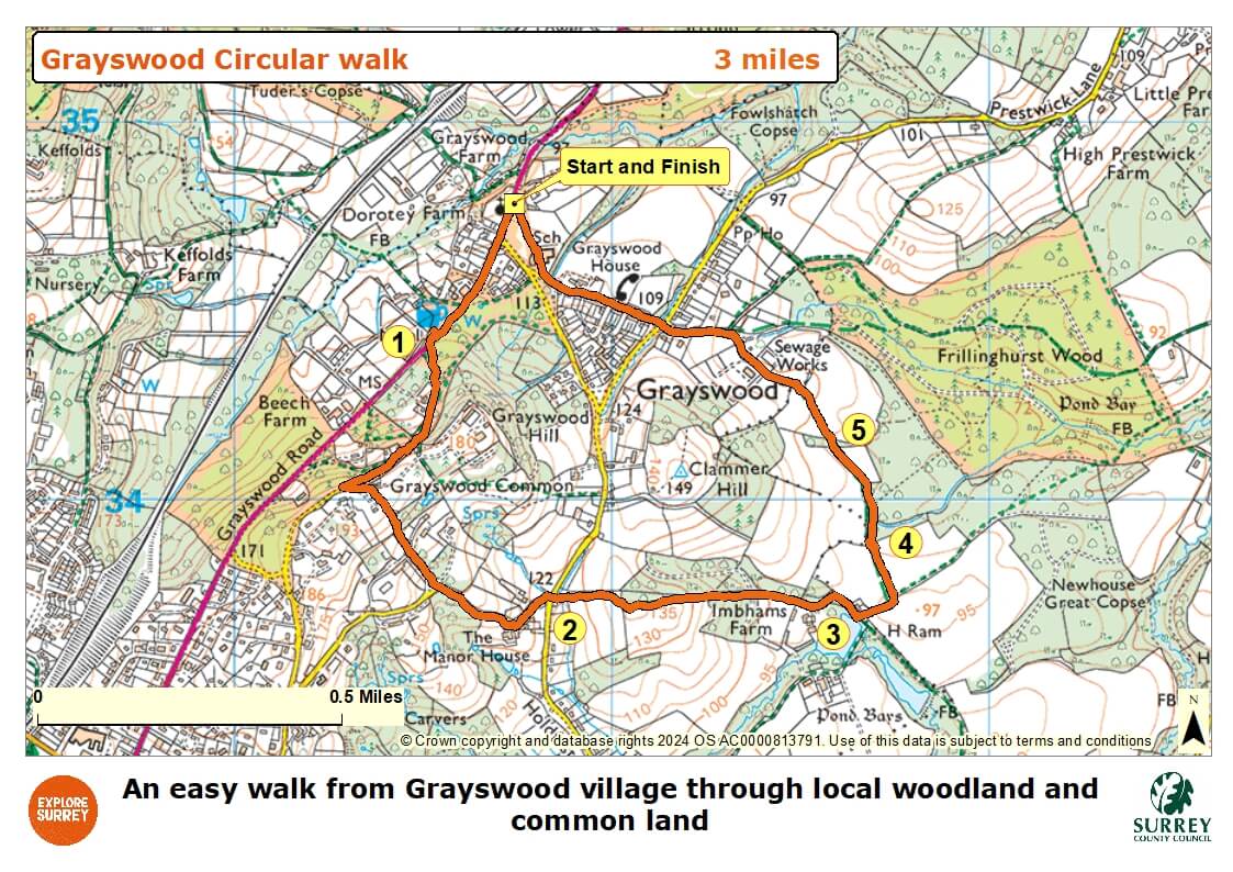
Map
The map shows the walk from its start in Grayswood village at All Saints Church, past the war memorial into woodland until you reach Holdfast Lane. It follows mainly public paths through fields, past a pond until you reach Lower Road, a school, a playground and across the village green to return to the car park at the village hall. Select the map of the route below to open a larger version in a new window, that can be printed, if necessary, using your browser print tool with landscape selected. Alternatively, you can save the image to your mobile device, for reference on your walk.