About the walk
A rural circular walk from Hydon Heath near Hascombe, in the Surrey Hills National Landscape. Explore several areas of mixed woodland, Hascombe village and a stretch of the Greensand Way with fabulous views.
 Route details
- Start and end address: National Trust (NT) Free Hydon Heath car park, Salt Road
- Car park postcode: GU8 4BB
- Difficulty: challenging terrain
- Distance: 5.5 miles, 9 kilometres
- Type of walk: circular
- Approximate time: 2.5 hours
- Accessibility: some steep hills, steps and gates
- Facilities: toilets and refreshments in The White Horse pub in Hascombe village
- Ordnance Survey Map: Explorer OL33 Haslemere and Petersfield and Explorer 145 Guildford and Farnham
Getting there
By car: Park at the free NT Hydon Heath car park (also called Hydon Ball), located on Salt Road between Milford and Hascombe.
By bus: Compass Bus route 42 serves Hascombe village. Adjust the walk to start at route point 4 outside the White Horse pub in Hascombe village, bus stops nearby. Take a look at Surrey bus timetables for further details.
Points of interest
Hydon's Ball was the name given to this site when a signal station was positioned here, used to synchronise time over long distances. The large stone seat is dedicated to Octavia Hill, one of the founders of the National Trust in 1895.
The Greensand Way long distance route runs for 57 miles across Surrey from Haslemere in the west to Limpsfield in the east at the Kent border. The entire route is 108 miles long and finishes almost at the coast in Kent.
The Hurtwood Control is over 2,000 acres of privately owned common land in the Surrey Hills National Landscape, available for all to enjoy. There are 15 free car parks across the Hurtwood.
Walk directions
This walk follows public footpaths and bridleways which cross private and public land. If you come across a problem on a public right of way, please notify us on our online fault reporting form.
For any feedback on this walk email us: countryside.bookings@surreycc.gov.uk.
Stages from start point through to end of walk
Please follow the Countryside Code.
The numbers of each stage of the walk correspond with the points shown on the map.
- Start point to Hydon's Ball
- Stage 1: Hydon's Ball to Greensand Way
- Stage 2: Greensand Way to Markwick Lane
- Stage 3: Markwick Lane to White Horse pub
- Stage 4: White Horse pub to B2130
- Stage 5: B2130 to High Barn
- Stage 6: High Barn to end of walk
Start to Hydon's Ball
Standing on the car park entrance track with your back to the road walk ahead along the track passing the car park on your left. Pass alongside the vehicle barrier and then stay on the main bridleway track walking uphill through the woodland. At the crossroads by the small stone pyramid keep straight ahead. At the top of the slope turn right onto a side track which leads you uphill towards a green kiosk. At the kiosk take the path straight uphill to the top of Hydon's Ball where you will find a large stone seat and a trig point. This makes a great place to pause and appreciate the views.
Stage 1: Hydon's Ball to Greensand Way
Standing with your back to the stone seat walk ahead towards the trig pyramid and you will see a choice of two paths. Keep left to take the path which starts immediately to the left of the brick pyramid. Follow this sandy path leading you downhill passing a few signposts along the way. Part way down you will come to a T-junction with a vehicle barrier on your right. Turn left and continue downhill for 50 metres to reach a T-junction at the bottom of the slope. Turn right for about 50 paces and then turn left onto a narrow path which leads you through a strip of trees coming out at a T-junction with fenced open pastures ahead. Turn right to follow the path with fenced fields on your left and woodland on your right. The path bends left becoming a grass track leading you between fenced livestock pastures.
At the T-junction in the track turn right to follow another section of track between fenced pastures. After passing a house behind a hedge on your right you will come to a pair of junctions with signposts to your right and left. Turn left at the first junction for a few paces to reach the second signpost. At this junction ignore the path to your right, instead keep ahead on the bridleway vehicle track, part of the Greensand Way. All signposts on the Greensand Way are marked with a GW in the centre.
Stage 2: Greensand Way to Markwick Lane
Follow the vehicle track between banks for just 30 metres then turn left where the path splits, walking up the bank to join the bank-top path, a continuation of the Greensand Way. Follow the path as it bends left and you will come to a signpost marking a choice of two bridleways. Take the right-hand one signed GW, a narrow path leading you downhill into the trees. Further along you will reach the end of the treeline on your right and you will be rewarded with far reaching views to the south. Stay with the bridleway path and eventually after passing through another stretch of woodland you will arrive at a junction with a lane, Markwick Lane.
Stage 3: Markwick Lane to White Horse pub
Turn left along the lane for about 100 metres then turn right to join a public bridleway marked GW. This sunken bridleway leads you uphill to reach an old vehicle gate. Pass through the gap to the left of this and continue directly ahead on the woodland path, which soon merges with the path visible across to your left. This next stretch of sunken bridleway continues uphill. At the top of the climb follow the bends in the path, left then right, to join a more open path leading you directly ahead. At the first two crossroads keep directly ahead, following the bridleway marked GW across the top plateau of the hill. This is part of The Hurtwood Control.
Stay on the Greensand Way and where you reach a staggered crossroads with a sleeper kerb ahead, go straight on stepping down this sleeper kerb. This bridleway will lead you steeply downhil crossing a number of steps marked with posts and red reflectors. About half-way down the slope look for a signpost on your right with a yellow GW arrow. Turn right here climbing up the bank, then keep left to join the path running on top of the bank. You will reach a signpost at a point where the path splits. Take the left-hand path and walk downhill. At the bottom of the slope you will reach a gate ahead. Go through the gate, down the steps and follow the enclosed path ahead with a fenced pasture on your left. Pass through the next gate to reach a crossroads and go ahead on the path between pastures. You will come out at the parking area directly opposite the White Horse pub in Hascombe.
Stage 4: White Horse pub to B2130
Standing at the entrance to the parking area with the White Horse pub ahead and to your left, cross the main road diagonally left to join Church Road. Walk along Church Road as it bends right and then left, passing St Peter's Church and the large village pond. Further along pass Matthew's Place on your right and then, as you reach the gateway for Upper House Farm ahead, turn left leaving the Greensand Way, to pass Lower House on your right. Ignore a kissing gate into a pasture on your right instead keep ahead on the main bridleway which bends right. At the next junction with Mill Lane signed to the left keep ahead on the stone track passing Forge Cottage on your left. At the T-junction in the path turn left and follow the grass path between fenced pastures. You will arrive alongside a wide gate to reach a junction with the B2130.
Stage 5: B2130 to High Barn
Cross over the road and go straight ahead to join the track signed as a public bridleway. This track leads you uphill passing a number of properties on your left. Where the track bends left into the last property keep ahead on the sunken bridleway path leading you into woodland. Towards the top of the climb you will pass two houses, High Winkworth and The Orangery, both on your left. 50 metres later you will reach a junction with the access drive to the house Sullingstead on your right. Turn left here and follow the access lane down to a T-junction. Turn right and follow the tarmac access road to reach a junction with the B2130. Turn sharp left to join another property access lane signed as a public bridleway, passing the sign for High Barn on your left.
Stage 6: High Barn to end of walk
Where the access lane bends left into the house named High Barn keep ahead on the unmade bridleway path, passing a pretty bluebell wood on your right. Further along the bridleway leads you downhill before bending right and uphill to continue with fenced pastures across to your left. Stay with the bridleway ahead leading you downhill again. At the bottom of the slope the fence on your left ends. Walk ahead on the woodland path for just over 100 metres to reach a T-junction with a stone vehicle track. Turn left and follow the grass and stone track uphill. At the top of the slope where the track bends right, you will see a signpost with a yellow arrow on your left. Turn left onto this short path which leads to the road. Cross over and continue on the footpath ahead which will lead you directly into the Hydon Heath car park where the walk ends.
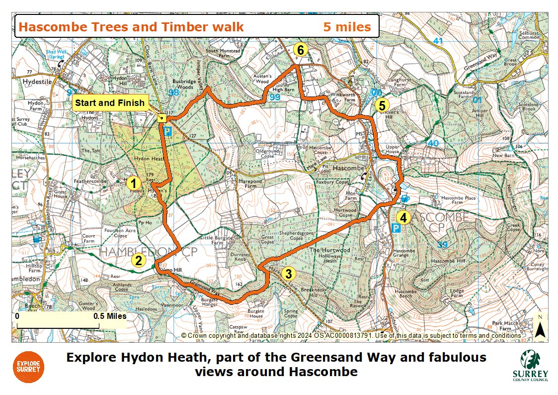
Map
The map shows the walk from the start at Hydon Heath car park uphill to Hydon's Ball and then downhill to join the Greensand Way. The route then reaches Markwick Lane, the White Horse pub and Hascombe village, the pond and church. The route goes to Mill Lane and then joins the B2130 junction and then through woodland to reach the car park. Select the map of the route below to open a more detailed version in a new window that can be printed if necessary, using your browser print tool. Alternatively you can save the image to your mobile device for reference on your walk.