About the walk
A 4 mile circular walk from Pirbright village on local quiet lanes passing historic buildings and through fields, woodland and heathland.

Route details
- Start and end address: Pirbright Green free car park
- Car park postcode: GU24 0LP
- Difficulty: moderate terrain
- Distance: 4 miles (6.5 kilometres)
- Type of walk: circular
- Approximate time: 2 hours
- Accessibility: several gates and kissing gates (allows people to pass through but not livestock), plus two low stiles and stretches along quiet lanes without pavements
- Facilities: There are two pubs in Pirbright village
- Ordnance Survey Map: Explorer 145 Guildford and Farnham
Getting there
Pirbright is located on the A324 road between Woking and Aldershot. The walk starts from Pirbright Green in the centre of the village.
By car: there are free car parks on Pirbright Green and also some roadside parking
By bus: Stagecoach bus route 91 serves Pirbright Green. Take a look at Surrey bus timetables for further details.
Points of Interest
St Michael and All Angels Church was rebuilt in 1784 and is one of the few examples of a Georgian church to be found in Surrey.
The private Manor House dates from the sixteenth century and was built on the site of a moated medieval manor. It formed part of the marriage settlement of Katharine of Aragon, Henry VIII's first wife.
The village green is part of Pirbright Common. Baron Henry de Worms lived at Henley Park nearby and was given the title of Lord Pirbright by Queen Victoria. He and his wife presented the hall and recreation ground to the village to commemorate the accession to the throne of King Edward VII in 1901.
Walk directions
This walk follows public footpaths and bridleways which cross private and public land. If you come across a problem on a public right of way, please notify us on our online fault reporting form.
For any feedback on this walk email us: countryside.bookings@surreycc.gov.uk.
Stages from start point through to end of walk
Please follow the Countryside Code.
The numbers of each stage of the walk correspond with the numbers shown on the map.
- Start to School Lane
- Stage 1: School Lane to Church Lane
- Stage 2: Church Lane to Manor House
- Stage 3: Manor House to Rowe Lane
- Stage 4: Rowe Lane to Whites Lane
- Stage 5: Whites Lane to Pirbright Green
- Stage 6: Pirbright Green to end of walk
Start to School Lane
Make your way to the bus shelter on the southern corner of Pirbright Green alongside The White Hart pub. Cross the main road and go along the side road signed as leading to Church Lane heading away from the green. At the junction keep left onto Church Lane and follow this to reach the parish church on your right. Go past the church and turn right onto the footpath over a stream and follow this for some distance to reach the road, School Lane.
Stage 1: School Lane to Church Lane
At the road turn left along the pavement. After 160 metres turn left opposite Causeway Farm along West Heath. Pass Thompsons Close and continue ahead to reach the road, Church Lane.
Stage 2: Church Lane to Manor House
Turn left along the road for 110 metres passing The Old School House then turn right along the footpath between fields. Cross a bridge and go through a kissing gate then walk diagonally right across the field heading back on yourself up Hazelacre Hill, passing a section of trees on your right. Go through a kissing gate keep slightly right and ahead to a kissing gate in the field corner into woods. Follow the path ahead along an old fence line to reach a track. Keep left at the track along the road to pass the entrance for Pirbright Lodge on the left. Opposite Pirbright Lodge is Admiral's Walk. Continue for 500 metres passing the pond by the Manor House on your left.
Stage 3: Manor House to Rowe Lane
Just past Millcroft on your right, keep right through a kissing gate. Go across the fields following the fence on the right and through two kissing gates to join an enclosed path. At the end of this path cross the main road to the left of the mini roundabout and turn right along the pavement for Guildford Road, B3032. Pass Burner's Farm on your left and continue to reach Rowe Lane on your left.
Stage 4: Rowe Lane to Whites Lane
Turn left into Rowe Lane and follow this as it bends right, ignoring the footpath into Whites Lane on the left. After 110 metres turn left at a kissing gate to go up onto the footpath. Keep straight ahead to a T-junction with a tarmac track. Turn left along the track then keep ahead at the signed crossroads which becomes a path into woods. Some way in, cross the footbridge using stiles at each end then turn immediately left. Keep ahead on the path beside the stream on the left. At the end of the holly bushes turn right then left to join the path running beside Pirbright Common on the right. At the junction pass to the left of the house. Keep ahead past Hogley's Farm and a house on your left, then keep ahead on a woodland path and then an access track for 100 metres to reach Whites Lane on the left, opposite Sandyburn.
Stage 5: Whites Lane to Pirbright Green
Turn left into Whites Lane. Pass between houses then keep ahead on the path to reach a farm access track. Turn left along the track and after 65 metres, turn right onto a signed footpath just before the property, White's Farm. Go through a gate and turn left across the field to reach a gate and footbridge near the field corner. Cross the footbridge and keep right through the woods and follow the long path ahead to pass through the woodland. Eventually the path turns left to join a tarmac drive. Follow the drive through a gate and continue to reach the road with The Cricketers pub on the left and Pirbright Green opposite.
Stage 6: Pirbright Green to end
Cross the road to enter the side road opposite then turn left onto the tarmac path across the green, passing a pond on the left and Lord Pirbright's Hall on the right. Beyond the hall keep left along the main road to reach the bus stop where the walk ends.
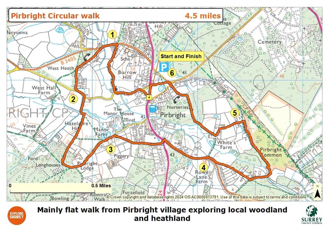
Map
The map shows the walk from Pirbright village green, past the school, church and private manor house. It then goes along rural lanes, through farmland and woodland until you reach Pirbright village and green, past Lord Pirbright's Hall to the carpark.
Select the map of the route below to open a larger version in a new window, that can be printed, if necessary, using your browser print tool with landscape selected. Alternatively, you can save the image to your mobile device, for reference on your walk.