About the walk
An undulating circular walk from Tilford village passing close to the historic ruins of Waverley Abbey and with a link to the North Downs Way. From the top of Crooksbury Hill there are good views to the South Downs on a clear day.

Route details
- Start and end address: Tilford Green free car park GU10 2BU
- Difficulty: Challenging
- Distance: 6 miles (9.5 kilometres)
- Type of walk: circular
- Approximate time: Allow 3 hours
- Accessibility: Take care on some busy roads to walk along or cross over. No stiles or gates, some steps and one steep climb to Crooksbury Hill
- Facilities: Toilets, pub and shop at Tilford Green. The walk passes 2 other pubs.
- OS Map Explorer 145: Guildford and Farnham
Getting there
By car: Free car park on Tilford Green
Points of Interest
The Medieval stone bridges at Tilford are part of a series of medieval bridges spanning the river between Farnham and Guildford. The bridges all have a similar design and were probably built for the monks of nearby Waverley Abbey.
Waverley Abbey, the first Cistercian monastery in England, was founded in 1128 by Bishop Gifford of Winchester. Following the dissolution of the monasteries in 1536 much of the building stone was sold, some being used to build Loseley House near Guildford. Some fine ruins remain however with a 500 year old yew tree that has grown into the ruins.
At the top of Crooksbury Hill there are hidden remains of a hillfort known as the Soldier's Ring. It is dated between the bronze age and early iron age and is thought to be an outlying defence for the nearby 12th century Farnham Castle.
The North Downs Way National Trail starts in nearby Farnham and runs across Surrey for 53 miles before it crosses into Kent. The whole trail is 153 miles in length and connects with other long distance trails.
Walk directions
This walk follows public footpaths and bridleways which cross private and public land. If you come across a problem on a public right of way, please notify us on our online fault reporting form.
For any feedback on this walk email us: countryside.bookings@surreycc.gov.uk
Stages from start point through to end of walk
Please follow the Countryside Code.
The numbers of each stage of the walk correspond with the points shown on the map.
- Start to Squires Hill
- Stage 1: Squires Hill to Sheephatch Lane
- Stage 2: Sheephatch Lane to optional Abbey detour
- Stage 3: Abbey detour back to Waverley Lane
- Stage 4: Waverley Lane to Crooksbury Hill
- Stage 5: Crooksbury Hill to The Sands
- Stage 6: The Sands to Farnham Road
- Stage 7: Farnham Road to Whitmead Lane
- Stage 8: Whitmead Lane to end of walk at Tilford Village Green
Start to Squires Hill
From the village green walk over to the north-east corner where you will find East Tilford Bridge, a medieval bridge over the River Wey. Cross the bridge using the left-hand pavement heading towards village shop. Just before you reach the shop and post office turn left onto a signed bridleway. Follow this path for approximately 540 metres to the top where you will reach a T-junction with Squires Hill Lane.
Stage 1: Squires Hill to Sheephatch Lane
Turn left along the lane and pass Tilhill House on the right. Keep straight ahead on the sandy track leading into woods. Soon you will come to a fork at a signpost take the right-hand fork signed with a red public byway arrow. Follow this sandy track heading uphill past the property Ebernoe left and then Sheephatch Farm on the right. At the staggered T-junction keep right until you reach Sheephatch Lane.
Stage 2: Sheephatch Lane to optional Abbey detour
Cross over this busy road with care and take the track opposite signed as a public byway. Follow this track between conifer plantations for about 400 metres, at the bottom of the slope you will come to a T-junction, turn left and follow the track which later swings right. Waverley Abbey ruins can be seen through the trees to your left depending on the season and Waverley Abbey House stands on the hill beyond. Continue ahead to reach the T-junction with Waverley Lane where you could take a detour to Abbey ruins.
Stage 3: Abbey detour back to Waverley Lane
To visit Waverley Abbey ruins turn left down the road. Turn left at the T-junction (safety note: traffic is difficult to see at this blind corner). Cross the river and turn left into the Abbey entrance. Here you will find information boards and a track which leads you to the ruins themselves. Return back to the main route where the byway track emerges onto Waverley Lane.
Stage 4: Waverley Lane to Crooksbury Hill
Turn right heading uphill along road edge for 230 metres (safety note: take care of traffic). You will pass the entrance to Keepers Cottage Stud Farm on the left. Immediately afterwards turn left onto track signed as a bridleway to Yew Tree Cottage. Follow the track steadily uphill passing Yew Tree Cottage on the left and continuing into woodland. At the top of the slope you will pass Waverley Cottages on your left and emerge out to a T-junction with Crooksbury Road. Cross over the road and take the signed bridleway opposite which swings sharp left to run parallel with road on left. Keep left at the first fork and leave the bridleway then left again at the second fork, this path will lead you into the back of Crooksbury Hill car park.
Turn right within the car park passing between a pair of benches and the information board on your left to join a signposted footpath for the Spider self-guided trail. The footpath leads you uphill via a series of steep wooden steps. At the very top (well done!) you will reach benches and a white trig point marking the summit of Crooksbury Hill. Take a seat and enjoy extensive views to the South Downs.
Stage 5: Crooksbury Hill to The Sands (and link to the North Downs Way)
Stand with your back to the view and join the path directly ahead. After just a few metres keep right on the narrow path to begin your descent. Further down at a fork keep right again. Continue through a staggered barrier, straight over crossroads and past a vehicle barrier towards the road. Do not continue to the road, instead turn left immediately after the barrier to join a footpath which runs parallel with road on your right. At the fork turn right out to the road and then turn left along a grass verge passing between houses. Follow the road down to crossroads at The Sands.
To join the North Downs Way, turn left at this point and follow the footway alongside the road to Sands Close. Cross the road carefully and join the North Downs Way at Farnham Golf Club.
Stage 6: The Sands to Farnham Road
Turn right past the Barley Mow pub on the right and follow this road taking care of traffic for 230 metres, passing village boundary signs. Turn right onto a long straight track, Long Hill. The lane climbs steadily between properties and then leads you down past a vehicle gate to enter Crooksbury Common. Keep ahead on the sandy track, a public bridleway, across Crooksbury Common for 720 metres. At the edge of the common continue ahead on the track past houses. Eventually the track leads you out to a T-junction with Farnham Road.
Stage 7: Farnham Road to Whitmead Lane and end of walk at Tilford Village Green
Cross over the road with care and turn right down the entrance lane leading to The Donkey pub. Continue on the track which leads you past the pub on the left and then begins to climb past Riversleigh Farm, also left. Just beyond this you will come to a staggered crossroads. Turn left passing Ravenswing on the left and stay on this track for half a mile to emerge out to a junction with Whitmead Lane. Turn right and follow the road uphill.
Stage 8: Whitmead Lane to end of walk at Tilford Green
After 300 metres, just after passing a house on your left and by a post box on your right, turn left to join a narrow fenced path between gardens. Stay on this path following the fence line on your right and it will lead you between horse paddocks and then along a ridge. Where the path ends keep ahead to merge with a residential access drive. Keep ahead along this drive to reach a junction. Turn left and then immediately right (safety note: take care of traffic) and this lane will lead you out to T-junction with the main road. Cross the main road and then turn left along the pavement, this will lead you past the village stores and back over the river bridge to reach the village green in Tilford where the walk began.
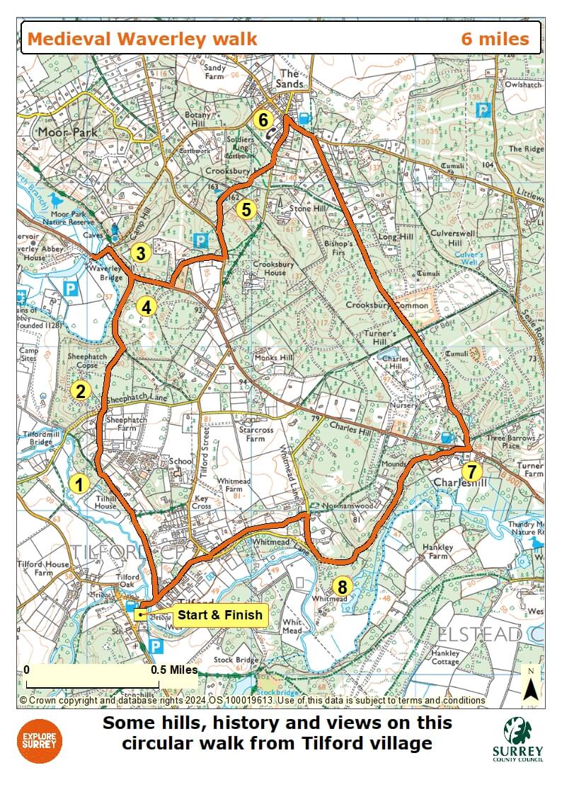
Map
The map shows the route from its start and finish points on Tilford Green free carpark. It goes close to Waverley Abbey and up Crooksbury Hill before descending to the Sands and a link to the North Downs Way. The route returns to Tilford Green across Crooksbury Common. Select the map of the route below to open a more detailed version in a new window that can be printed if necessary, using your browser print tool. Alternatively you can save the image to your mobile device for reference on your walk.