About the walk
A circular rail to ramble walk through the historic village of Witley, with its surrounding rolling farmland and heathland, beautiful views and an opportunity to extend the route by exploring Mare Hill Common.

Route details
- Start and end address: Witley railway station, parking charges apply
- Car park postcode: GU8 5TB
- Difficulty: moderate terrain
- Distance: 5 miles, 8 kilometres
- Type of walk: circular rail to ramble
- Approximate time: 2.5 hours
- Accessibility: one stile with an adjacent dog gate plus kissing gates (allows people to pass through but not livestock) and steps
- Facilities: toilets at Witley station
- Refreshments: The White Hart pub in Witley village at stage 3
- Ordnance Survey Map: Explorer OL33 Haslemere and Petersfield and 145 Guildford and Farnham
Getting there
By rail: The walk starts and ends at Witley railway station, GU8 5TB
By car: The station has its own large pay and display car park
By bus: Stagecoach bus routes 70, 71 and 72 serve Witley railway station. Take a look at Surrey bus timetables for further details.
Points of interest
This walk connects up with part 3 of the Greensand Way long distance route that winds its way through beautiful hilly countryside for 103 miles from its start in Haslemere and its finish at the coast in Kent.
Enton Hall dates back to 1881 when it comprised a mansion, stable yards, cottages and coach house. In 1948 it became a health hydro and in 1956 the James Bond author, Ian Fleming, was a spa resident. Following a fire, the site was redeveloped into a private residential estate of apartments and cottages including private facilities (golf course, tennis courts and a fitness centre) and beautiful landscaped gardens.
Mare Hill Common covers 40 hectares and is managed for nature conservation as well as recreational activities. Look out for roe deer, adders and common lizards and a huge range of birds, including nightjar and woodpeckers.
Walk directions
This walk follows public footpaths and bridleways which cross private and public land. If you come across a problem on a public right of way, please notify us on our online fault reporting form.
For any feedback on this walk email us: countryside.bookings@surreycc.gov.uk.
Stages from start point through to end of walk
Please follow the Countryside Code.
The numbers of each stage of the walk correspond with the numbers shown on the map.
- Start to Moor Cottage junction
- Stage 1: Moor Cottage junction to railway bridge
- Stage 2: Railway bridge to All Saints Church
- Stage 3: All Saints Church to Mare Hill Common
- Stage 4: Mare Hill Common to Parsonage Farm
- Stage 5: Parsonage Farm to Bannacle Hill Road
- Stage 6: Bannacle Hill Road to end
Start to Moor Cottage junction
Leave Witley station via the Platform 2 exit and turn left heading down the one-way exit road. At the T-junction with the road, cross over and take the narrow footpath directly ahead leading you between garden fences signed as part of the Greensand Way. Continue all the way to the end of this footpath where you will go through a staggered barrier to the grass verge alongside the main A283. Turn left along the pavement for about 20 metres and then cross over the main road to turn right into Wormley Lane. You will pass a beautiful old property with a triple chimney, Wood End, on your left.
Ignore the first footpath signed sharp left and continue to the junction with Hambledon Park. Join the signed bridleway here straight ahead and slightly to the left still following the Greensand Way. Follow this stone track leading you uphill ignoring any paths to the side. Further along the track begins to go downhill to reach a junction of paths just before you reach Moor Cottage junction ahead.
Stage 1: Moor Cottage junction to railway bridge
Turn left for a few paces to reach a point where there is a choice of two bridleways both signed with blue arrows. Take the right-hand one that is a fairly level path leading you through a section of holly bushes. Stay with this bridleway going through the woodland leading you downhill to reach a junction of paths with a house on the left, Busses Cottage. Take the vehicle access track ahead and stay with this track as it goes through the woodland. The track leads you past Sweetwater Cottage on your left and then a few more properties each side. At the end of the track you will arrive at a junction with a quiet lane, Water Lane. At this point you have views to your left over the large lake, Sweetwater Pond and to your right, the grounds of Enton Hall. Turn right along the lane for just a few paces and then turn left onto the signed public footpath which leads you into the next section of woodland. Further along this path leads you through an arched tunnel beneath a railway bridge.
Stage 2: Railway bridge to All Saints Church
At the far side walk ahead on the obvious woodland path which soon leads you over a stream across a small footbridge. Just beyond the bridge you will come to a T-junction with a track, turn right along this, passing the entrance for Well Cottage on the right. Keep ahead through the gap in the hedgerow to reach the corner of a large playing field. Walk directly ahead with the boundary fence running to your right and passing the children's play area on your left. Through the fence to your right you will see across to Enton Lakes. Keep left beyond the play area heading for the exit gate between the large beech tree on the left and the village hall pavilion on the right. Pass through the gate and turn right along the pavement of the A283 passing the pretty black and white frontage of the village hall, Chichester Hall.
Beyond the hall cross over the road to the left-hand pavement. Follow the pavement heading into the village centre passing a number of pretty cottages with black and white timbered gables. On the left you will pass the 1883 Club and on the right you will pass The White Hart pub. With the pub on your right turn left into Church Lane and follow this past the old vicarage on your left and All Saints Church on your right.
Stage 3: All Saints Church to Mare Hill common
Continue along Church Lane passing the infant school on your left and then passing Jubilee Hall also on your left. Ignore the path signed to the left instead keep right following the line of the wall on your right signed as a public footpath. Walk ahead through the parking area to reach the 1912 golden stone property Witley Lodge, ahead. Take the signed footpath ahead and slightly to the right, a narrow footpath between fences (Not the vehicle access track for the other houses). The path runs parallel with the access road on your right. Further along where the access road ends keep ahead on the path leading downhill into woodland and then bends left. Stay with this path as it turns right leading you down a flight of steps, passing a pond on your left and then bending left to reach a junction alongside the entrance drive for the property, Lower Roke.
Keep straight ahead here following the path through a section of coppiced woodland and then uphill alongside a wire fence on your right. You will come to a junction with a track, keep straight ahead passing a row of properties on your left. Take time to enjoy the views across the valley on your left. After passing the last house, Mare House, turn left onto the signed footpath which soon reaches a junction with a stone access drive. At this point the walk takes a short detour to visit the viewpoint on Mare Hill common. Turn right to reach the road cross over and then go straight ahead on the narrow path leading into Mare Hill common. Follow the path through the gorse bushes and you will emerge to a junction of tracks. Go straight ahead to join the narrower track and follow this to the top of the hill with the remains of a bench. This is a great point to enjoy the expansive views to the north which stretch for miles on a clear day. If you wish to extend the walk you can do so by exploring Mare Hill common and then returning to this point when you are ready to continue.
Stage 4: Mare Hill common to Parsonage Farm
When you are ready to continue turn round and retrace your steps back to the track junction. Cross over and take the narrow path you took to enter the common following it through the gorse and out to the road. Cross over and walk ahead into the entrance drive for Lemon Field Cottage. Follow this entrance track as it bends right and leads you downhill. Pass to the left of Mare Hill Cottage alongside a disused stile to reach the next stile ahead. Cross this to join the fenced grass path running through the centre of the large grass pastures. Halfway along the fields pass through the kissing gate ahead to reach a junction of fenced paths. Go straight ahead ignoring the left-hand path and follow the fenced path for some distance, enjoying the views across the surrounding rolling pastures. At the far end of the path you will come to a single gate ahead with a signpost marking a junction of paths, with the converted barns of Parsonage Farm just across to your right.
Stage 5: Parsonage Farm to Bannacle Hill Road
Go through the gate ahead and take the obvious path through the grass meadow. You will come out to a vehicle drive, turn left along this to reach a T-junction marked with a signpost with Parsonage Farm bungalow on your right. Turn left onto the stone track bridleway and follow this all the way out to a T-junction with a quiet country lane. Turn left along the lane continue past Winkford Farm Cottages on your left and 60 metres later, ignore the footpath signed to the left. A few metres later turn sharp right onto the signed bridleway which leads you downhill into the woodland. Stay with this path soon running with a fence on the left, for some distance. The beautiful area of coppiced woodland on your left is awash with bluebells in the late spring. On the left you will pass a garden entrance into the grounds of King Edward's School and then you will come out to a stone access drive with a property on your left. Keep ahead along the drive and you will reach a junction with a quiet country lane, Bannacle Hill Road.
Stage 6: Bannacle Hill Road to end
Cross over and take the footpath ahead, part of the Greensand Way. Follow this path as it bends right along a ridge within Sandhills common to reach a pair of benches. The views here on a clear day are magnificent, this time looking towards the south. Immediately after the benches turn left to join the subtle path heading downhill to reach a junction with a gravel drive. Turn left along this for a few paces to reach the road, Brook Road. Cross over, walk ahead for a few paces and then keep left to follow the stone access track. The track narrows to a footpath leading you through the woodland. At the far side of the trees you will come out to another gravel drive alongside Pinewood Lodge. Keep directly ahead along the vehicle track and follow this until you reach a crossroads junction, with the property called Inglewood just ahead and slightly to your right. Turn right here following the vehicle track heading downhill and then narrowing to a tarmac footpath. The path bends left and leads you directly onto Platform 1 of Witley railway station. If you need to reach the car park, turn left along the platform and use the steps and footbridge to cross the railway to reach Platform 2 and the car park exit where the walk ends.
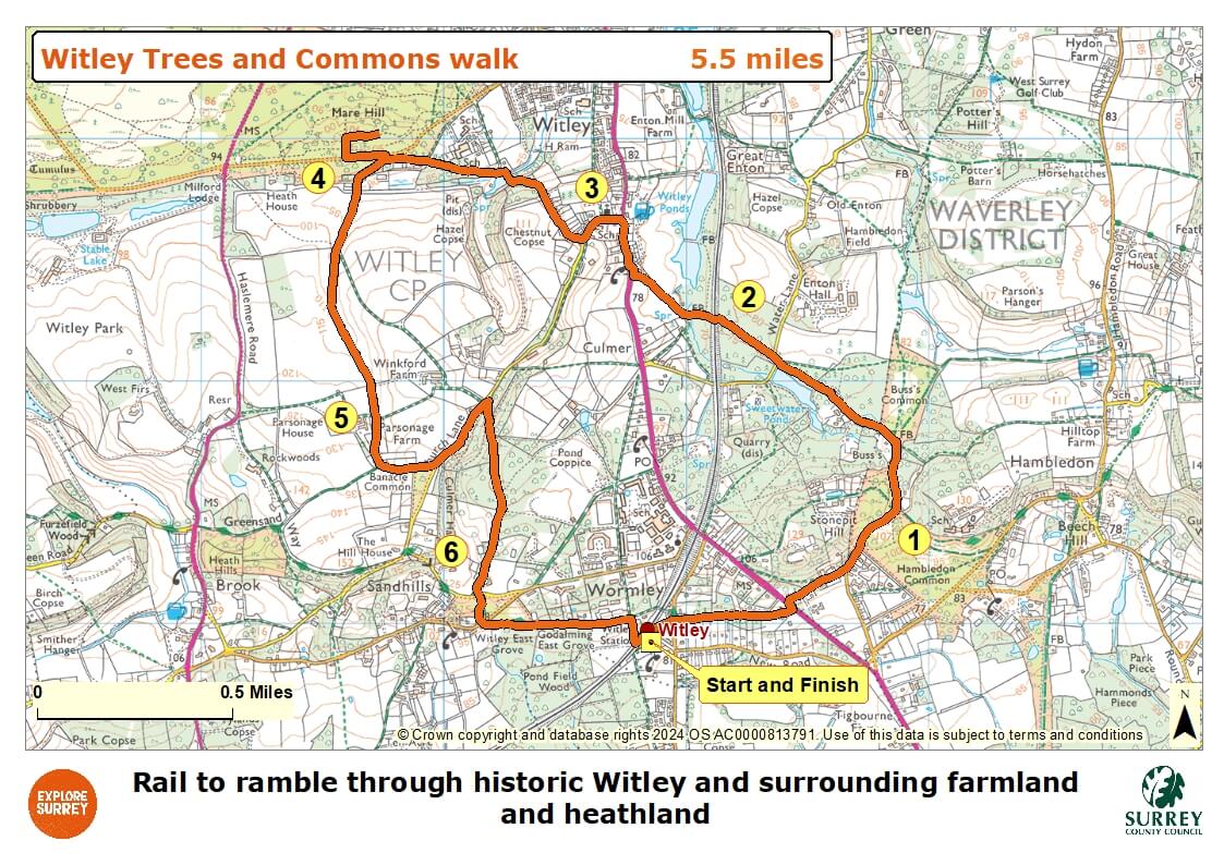
Map
The map shows the walk from Witley railway station to the Greensand Way path until Moor junction and railway bridge. It then joins the A283 near Witley village centre until Church Lane where public footpaths lead onto Mare Hill Common. The path goes through fields until Parsonage Farm and then on through woodland to Bannacle Hill Road, rejoining the Greensand Way at Sandhills common until Brook Road leading back to Witley station platform 1. Select the map of the route below to open a more detailed version in a new window that can be printed if necessary, using your browser print tool. Alternatively you can save the image to your mobile device for reference on your walk.