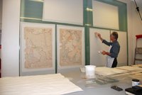
 Maps and plans deposited with Surrey History Centre come in a variety of sizes, from large tithe and estate maps to small pull-out plans in a book. For reasons of space and manageability, we repair larger maps using an in-situ vertical glass lightbox in the Conservation studio. The lightbox is made up of two sheets of glass, each measuring 2m x 4m x 12mm, a more practical decision since the installation of one larger panel would require the removal of the roof if the glass needed replacing! Fortunately, the two sheets of glass did fit through the door of the studio!
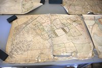
These photographs illustrate one example of the many repairs we have carried out using the vertical lightbox. The map shown is one of 133 marked copies of Ordnance Survey 25" sheets recording 'hereditament' plot numbers assigned under the Finance (1909 to 1910) Act 'Domesday' survey of land values. As we don't know exactly when the markings were made, a date of circa 1912 has been applied in most cases. The maps measure 1040 x 725mm, and came to us rolled and lined with a brown linen fabric. A third of the collection had suffered significant damage – particularly water - due to poor storage, and many contained holes, tears, creases and stains. The linings had a layer of dust and dirt, and were stained and darkened.
 The treatment of these maps is divided into several stages. First the front of the map is cleaned using a museum vacuum cleaner. The reverse side is mechanically cleaned with a wide brush, erasers and a wishab sponge. A surface pH (potential hydrogen) reading is taken to indicate the amount of acidity present in the paper. Then the stability of the inks and watercolours is tested to check if they will be affected by wash water, solvents or chemicals used in the conservation process.
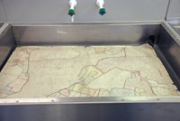
The fabric lining is removed dry and the paper map is then washed in water supported by a mesh fabric. This process removes soluble acids, adhesive residues and other chemicals, and allows wrinkles and other distortions to be flattened out. When removed from the sink, the old paste is scraped off the map while still damp.
 Next, the lightbox wall board is prepared: a sheet of terylene is glued to the glass to hold the map and facilitate removal when the repair work is completed. An oversized calico backing for the map is cut and glued to the terylene; the calico is pasted with wheat starch paste which provides a slippery surface and enables the map segments to be eased into place. The wet map, faced with a sheet of polyester, is lifted and placed onto the backing fabric. A small printer's roller is used to lightly press through the polyester to adhere the map evenly to the calico. Adjustments can be made while the paste is still wet, and any loose pieces can now be fitted to the map. Repairs to tears and areas of loss are made good with specialist western papers or Japanese tissues.
When dry, the map is removed from the glass wallboard, the terylene is pulled away from the backing and the excess calico trimmed to the map edge. Smaller maps are generally stored in plan drawers, but the largest maps are rolled on a 'former', covered in cloth, and placed securely on a shelf in our strongrooms.
The recent Zoom talk by our conservator Rachel Marsh, taking us through the intricate and challenging process of conserving a tithe map, will be available to purchase soon.

