What is the Reigate and Banstead LCWIP?
The Reigate and Banstead Local Cycling and Walking Infrastructure Plan (LCWIP) is a ten-year investment plan for walking and cycling in the borough. It identifies where we want to prioritise investment and sets out some initial options and ideas for improving walking and cycling across the borough.
LCWIPs are the best practice approach nationally for planning walking and cycling improvements and our process follows Department for Transport guidance. To find out more about LCWIPs, including what they are and the process that we have followed to develop LCWIPs for the county, please see our plans to improve cycling and walking page.
The Reigate and Banstead LCWIP focuses on strategic network connections and aims to create a wider walking and cycling network for the borough. Local neighbourhood and street level interventions are not included within the LCWIP and will be part of separate workstreams that aim to improve walking and cycling provision at smaller scales. For example, we aim to develop 'Liveable Neighbourhood' schemes to increase the comfort, safety and accessibility of walking and cycling on residential roads by recognising the importance of these streets as places for people, and not just their importance for the movement of vehicles. 'Liveable Neighbourhoods' will create attractive local environments that connect residents to the wider LCWIP network and make walking and cycling easier, safer, more enjoyable, convenient and fun for everyone. To find out more about our plans for walking and cycling at the street and neighbourhood scale, please see our Local Transport Plan policies for Planning for Place and for Active Travel and Personal Mobility.
If you would like to view the Reigate and Banstead LCWIP report in full, please email surreytransportplan@surreycc.gov.uk to request a copy.
Executive summary
The Reigate and Banstead LCWIP's key proposals are cycling and walking routes, which together create a walking and cycling network for the borough.
All cycling and walking routes identified in the LCWIP have been designated as either Phase 1, 2 or 3. This helps to prioritise investment over the LCWIP's ten-year lifespan. Phase 1 routes are those that we aim to implement in the short-term, whilst we aim to implement Phase 2 routes over the medium-term, and Phase 3 routes in the longer term. Prioritisation of the routes and corridors is based on a number of factors, including:
- Present and future demand for the route, including local stakeholder input, road traffic collision data and projected usage.
- The quality that improvements will deliver compared to the provision that currently exists on the route.
- How the route will contribute to increased access for walking and cycling to key destinations such as schools, doctors' surgeries, hospitals, rail and bus stations, high streets, and parks
The full LCWIP report includes network maps that show the locations of all of the cycling and walking routes. It also includes initial concept ideas for the Phase 1 routes and explains and lists the full prioritisation programme of all of the different cycling and walking routes.
The LCWIP has considered the full extent of the borough, with an emphasis on key trip attractors and destinations that will encourage and allow more people to take up walking and cycling as their everyday types of travel.
Cycling network
Phase 1 cycling routes
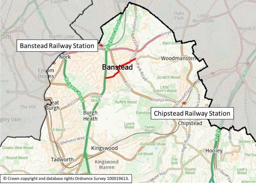
Banstead Town Centre to A217
This route will upgrade the current provision for cycling to encourage and enable more cycling into the town centre. It will serve the town centre and residential area to the south and west. The approximate length of this route is 1.5 kilometres.
The route presents two possible other options: via Bolters Lane and High Street, or via Garratts Lane and Court Road. The LCWIP report presents potential design options for each of these, which will be further explored during feasibility.
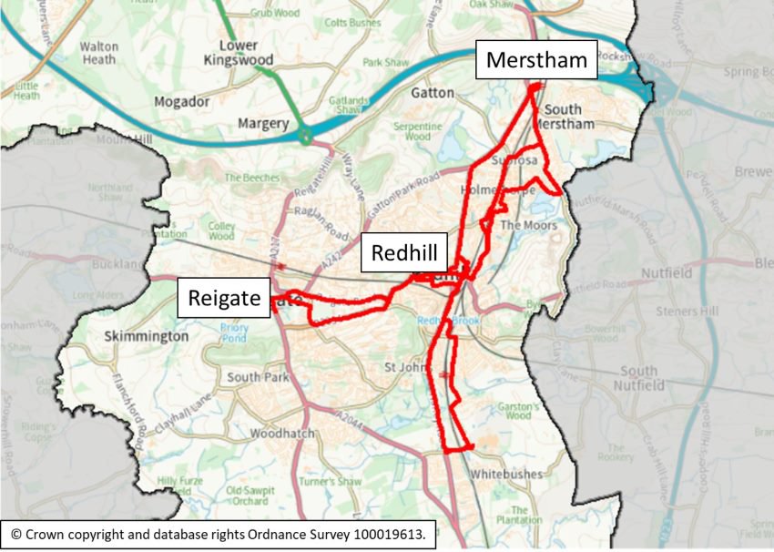
Merstham to Redhill
This route serves both Merstham and Redhill town centres and looks to improve existing cycle facilities and implement new ones where possible. The route runs from Merstham to Redhill station via Nuffield Road, Battlebridge Lane, Frenches Road and St Anne's Drive. The approximate length of this route is 3 kilometres.
Merstham and Redhill are within ideal cycling distance of one another, with only slight gradients on the route between them. Data analysis shows very high potential for cycling between these locations and many cyclists currently use this route. A high-quality cycle route along this corridor would enable residents to travel safely and comfortably by bike.
Redhill to East Surrey Hospital
This route will provide a direct link between Redhill and East Surrey Hospital through Earlswood. The route is approximately 1.5 kilometres, running from Redhill station in the north to the junction with Woodlands Road in the South.
There are multiple options for this route, including a route on the A23 and upgrading the existing Brook Road cycle route. Potential options will be explored further during feasibility.
Redhill to Reigate
This route represents a strategic connection between Redhill and Reigate where, at present, cycle provision is inconsistent, or in some places non-existent. The route seeks to provide a direct, quick and convenient connection between the two places. There are two other route options for this route to be explored at feasibility: via Reigate Road (A25), or Blackborough Road (B2034).
Data shows that this route has the potential for medium to high usage, and Department for Transport traffic count data shows that 100 to 200 people currently cycle this route each day. The proposals seek to create a safe, comfortable, and convenient cycle connection between Redhill and Reigate.
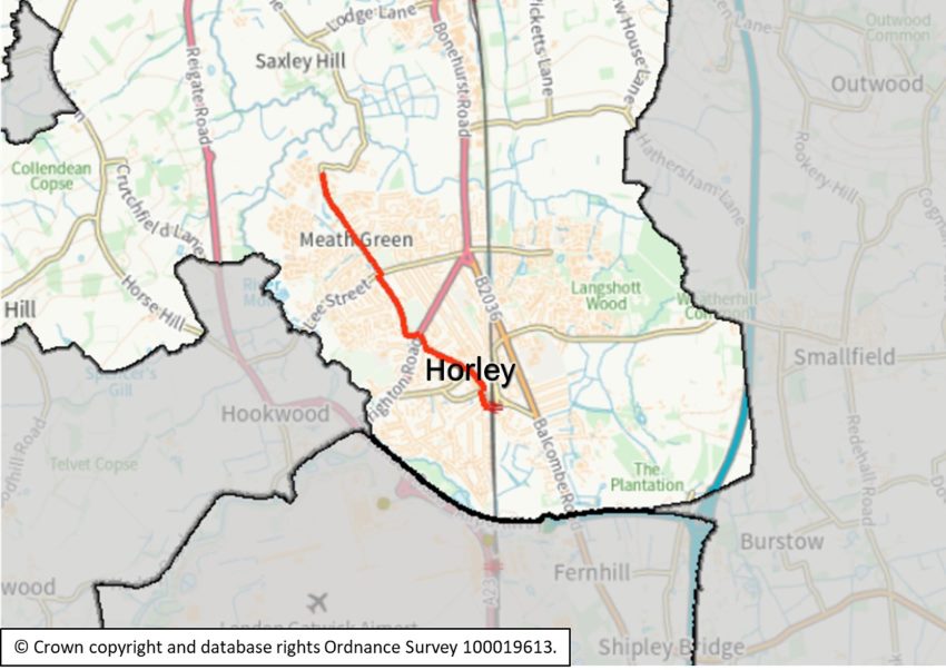
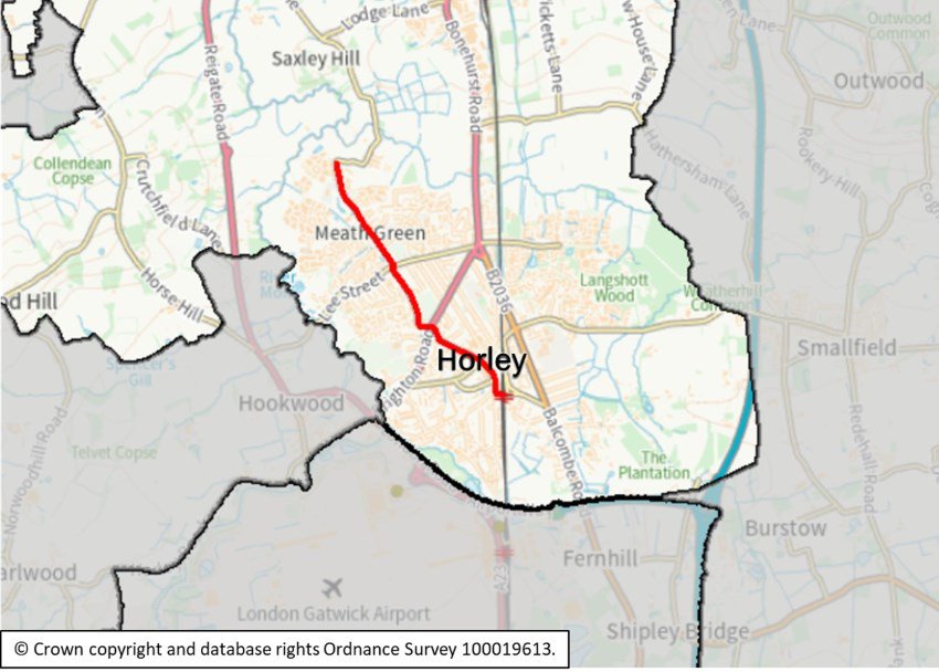
Horley Railway Station to Westvale
This route serves the new Westvale development and seeks to provide a high-quality cycle link between the development and Horley town centre.
The route includes Meath Green Lane, Vicarage Lane and Victoria Road. The approximate length of the route is 2.8 kilometres.
Maps 1, 2 and 3 show the locations of the Phase 1 cycling routes in the northern, central and southern parts of the borough.
Map 1: Phase 1 cycling route in the northern area of the borough:
Map 2: Phase one cycling routes in the central area of the borough:
Map 3: Phase 1 cycling route in the southern area of the borough:
Phase 2 and 3 cycling routes
- Reigate north-eastern approach. This route extends from the junction with the A242 and A23, to Reigate town centre. Approximate length: 3 kilometres.
- Merstham station to Bletchingley Road. This route will link residential streets to the station along Bletchingley Road. Approximate length of the corridor: 1.5 kilometres.
- Redhill town centre, north-western approach. This route includes Carlton Road, Park Road, and Warwick Road. There are a number of possible route options to be explored, including along Green Lane. Approximate length: 1.3 kilometres.
- Redhill south-western approach (Pendleton Road). This route aims to link the southwest of Redhill and the southern side of Reigate. Approximate length: 2.1 kilometres.
- Woodhatch to East Surrey Hospital. The route connects the residential area on the southern side of Reigate to East Surrey Hospital, via Three Arch Road.
- Reigate town centre. There are a number of different potential route options through the town centre to be explored. Approximate route length: 1.3 kilometres.
- Tattenham Corner to the A217. This route extends from the parade of shops at Tattenham Corner to the A217. Approximate length: 2.2 kilometres.
- Reigate southern approach. Potential options for this route cover the A217 and A2044, as well as Park Lane and Sandcross Lane. These options will be further explored. Approximate length: 2.5 kilometres.
- Horley to Gatwick South Terminal (via Balcombe Road). This route would aim to connect Horley town centre to Gatwick Airport. Approximate length: 2.5 kilometres.
- Woodhatch to Horley. There are several potential route options, including Reigate Road (A217) or Lonesome Lane. These options will be explored further.
- Preston to Kingswood Station. This route aims to link Preston's shopping parade to Kingswood Railway Station. There is potential for this route to follow Shelvers Way and Waterhouse Lane. Approximate length: 2 kilometres.
- Preston to Tadworth Station. This route would provide a link between Preston's shopping parade and the railway station at Tadworth. Potential route options include the B290 or Kingswood Road.
- Orchard Drive to The Acres. Potential options include the new access road to The Acres as well as Lake Lane, to connect to the proposals for Cross Oak Lane.
Walking network
Phase 1 walking routes and zones
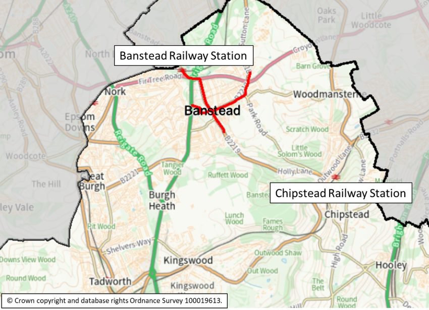
Banstead Railway Station to the High Street
This corridor serves Banstead High Street, three local schools, the local play area and improves access to the station for pedestrians from the high street and surrounding residential areas.
It covers Banstead Road, Winkworth Road, Bolters Lane, Holly Lane, High Street and Sutton Lane. The route aims to improve road safety for all road users whilst being sensitive to the local area's existing character and aligns with plans for the Banstead town centre cycle corridor.
Redhill Railway Station to Wray Common
This route extends along the High Street and the A25, linking to St Joseph's Primary School and the leisure centre, as well as serving local residential areas. It aims to improve access to Redhill Railway Station, the bus station and Wray Common for pedestrians. Proposals include upgrading the Princes Way roundabout crossings, widening footways and adding new crossings along the route.
The route overlaps with National Cycle Route 21 so includes elements to improve road safety and comfort for both pedestrians and cyclists. Additional cycle improvements are also proposed through the Redhill to Reigate Phase 1 cycle route.
Earlswood to East Surrey Hospital
This route links Earlswood Railway Station to the local residential area, YMCA, Earlswood Commons and East Surrey Hospital. The corridor extends along local residential roads and off-street paths that are shared with cyclists. Proposals include improving pedestrian facilities on St James Road and adding crossing facilities on the A23 to improve access to Earlswood Commons.
The route overlaps with National Cycle Route 21 and links to the Redhill to East Surrey Hospital Phase 1 cycle route.
Horley Railway Station to Westvale Park
Proposals for this route aim to improve the pedestrian connection between Horley Railway Station and the Westvale Park development area, including through the creation of new footways and widening existing footways. The route covers Vicarage Road, Victoria Road, Meath Green Lane, the local green space and the Westvale development site and aims to accommodate the increased walking demand that will be present once the development is fully constructed.
This corridor overlaps with the Horley Railway Station to Westvale cycle route.
Woodhatch to Reigate
This route serves Reigate's commercial area, Woodhatch residential area and links to Priory Park, the county council's Woodhatch Place offices and the adjacent development site which will include a new primary school. Proposals include new footways, more accessible paths and upgraded crossing facilities.
The route proposes two alternative options which will be explored further during the feasibility stage: a route option using off-street paths and quiet roads along Isbells Drive, Smoke Lane, local green space and Hornbeam Road, linking to Bell Street and Woodhatch Road; or a route option along Cockshot Hill and the service road, directly linking to Woodhatch Road.
Maps 4, 5 and 6 show the locations of the Phase 1 walking routes in the northern, central and southern parts of the borough.
Map 4: Phase 1 walking route in the northern area of the borough:
Map 5: Phase 1 walking routes in the central area of the borough:

Map 6: Phase 1 walking route in the southern area of the borough:
Phase 2 and 3 walking routes and zones
- Brighton Road. This route extends along Brighton Road between Chequers roundabout and Longbridge roundabout.
- Horley Station to Gatwick Airport via Riverside Park and Brighton Road. This route aims to link Horley town centre to Gatwick Airport. Two potential route options are proposed: the first covers quiet roads and off-street paths in Riverside Park; the second extends along Massetts Road, Brighton Road and proposes a new off-street path parallel to London Road.
- Tattenham Corner to Preston Park Leisure Centre (Merland Rise). This corridor links Tattenham Corner Railway Station to Preston Park Leisure Centre and Epsom Dons Primary School via Merland Rise.
- Tadworth to Kingswood. This route will link the centres of Tadworth and Kingswood, including the respective railways stations and local shops. It will serve two schools, the local green area and includes the crossings on Brighton Road roundabout.
- Reigate town centre. This corridor extends from the Homesdale Community Infants School north of the railway line to the railway station, along the A217 to Castle Park south of the railway line and to Church Walk, linking to three schools. It accesses the railway station and the commercial area along Bell Street and Church Street.
- North Redhill (London Road to Mercer's Lake). This corridor extends along the Watercolour development and the business area towards Frenches Road, linking to Redhill town centre. Proposals include improving pedestrian provision around Homesdale Avenue, Canalside and Frenches Road.
- Chipstead to Woodmansterne (North). Two options are proposed for this corridor. The first links Chipstead Railway Station to Woodmansterne via Station Approach, Outwood Lane, Chipstead Way, Woodmansterne Street and Carshalton Road. This route option serves the railway station, local school, hospital, green space and two play areas. The second route option proposed links Chipstead Railway Station to Chipstead Valley Primary School, towards Woodmansterne Railway Station, via Station Approach, Outwood Lane and Chipstead Valley Road. This option serves the railway station, local school and golf course.
- Merstham to Woodfield School. Covering the area around the railway station, this corridor serves the local commercial facilities and links to three schools via Bletchingley Road. Proposals include improving pedestrian access to Merstham Railway Station by upgrading surfacing and introducing new crossings.
- Salfords Station to Copsleigh Avenue. This corridor links to the business park east of the railway lines, the residential area to the west of the A23 and extends north to link to the local residential area and Salford's Primary School.
- Tattenham Corner to the Beacon School (Great Tattenhams). Linking Tattenham Corner Railway Station to Beacon School via Tattenham Way, this corridor also serves the local commercial area and Shawley Community Primary School. Proposals include the introduction of new pedestrian crossings.
- Nork (Epsom Downs to Banstead Station). This corridor links Epsom Downs Railway Station to the local commercial area on Nork Way via Warren Street, and Banstead Railway Station via Fir Tree Park. The route will improve pedestrian access to Warren Mead Junior School and serve the surrounding residential area.
Next steps
The Reigate and Banstead LCWIP report should be used to support the case for further stages of design, assessment, and stakeholder engagement, and to secure funding to progress improvements for the routes identified by the report. Because the LCWIP is intended to facilitate a long-term approach to developing active travel proposals, over a period of approximately 10 years, all of the corridors identified within the active travel network maps are recommended for further consideration at an appropriate time.
The next stage of implementing the Reigate and Banstead LCWIP will be to further develop the design concepts for the Phase 1 cycling and walking routes into a feasibility level of design and assessment. This will include full public consultation, allowing residents and other local stakeholders to have their say on the individual scheme proposals.
The LCWIP will be reviewed and updated periodically, particularly in response to significant changes in local circumstances such as the publication of new policies or strategies.
If you wish to view the full Reigate and Banstead LCWIP report, please email surreytransportplan@surreycc.gov.uk requesting a copy.
Redhill to East Surrey Hospital
Following the finalisation of the LCWIP report, several routes have been, and will continue to be, the subject of bids to external funding streams. The Redhill to East Surrey Hospital cycling route has already secured detailed design and construction funding through DfT's Active Travel funding stream and is now progressing through these stages. This page will be updated as and when other proposed routes are awarded funding.
